Property Record
188 Fries Mill Rd, Blackwood, NJ 08012


NEARBY LISTINGS FOR SALE OR LEASE
Property Detail
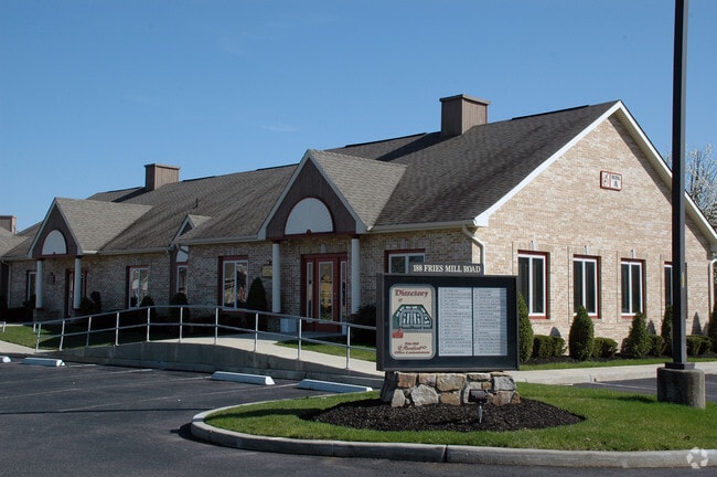
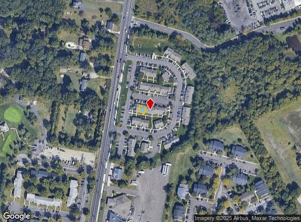
188 Fries Mill Rd
Philadelphia-Camden-Wilmington, PA-NJ-DE-MD
The Washington Condominiums
18-00115-02-00009-0000-CN002
EST.94 P/O UNIT 1
Officecondo
Gloucester
X
New Jersey
34015C0206E
9
2024
0.07 AC
2025
Gloucester County
501205
Philadelphia
DEMOGRAPHICS near 188 Fries Mill Rd
1 Mile
3 Mile
5 Mile
2024 Total Population
6,382
59,848
172,069
2029 Population
6,600
61,172
175,663
Pop Growth 2024-2029
+ 3.42%
+ 2.21%
+ 2.09%
Average Age
43
41
40
2024 Total Households
2,399
21,428
61,820
HH Growth 2024-2029
+ 3.58%
+ 2.33%
+ 2.19%
Median Household Inc
$90,438
$110,399
$91,561
Avg Household Size
2.60
2.70
2.60
2024 Avg HH Vehicles
2.00
2.00
2.00
Median Home Value
$272,425
$270,450
$253,122
Median Year Built
1974
1982
1981
Nearby Places
Map Layers
Map Styles
 Street
 Aerial
- Restaurants
- Banks
- Shops
- Fitness
- Groceries
PUBLIC TRANSPORTATION
COMMUTER RAIL
Lindenwold (NJT) (Atlantic City Line - NJ Transit Commuter Rail (NJ Transit))
DRIVE
WALK
Distance
Lindenwold (NJT) (Atlantic City Line - NJ Transit Commuter Rail (NJ Transit))
16 min
8.4 mi
AIRPORT
Philadelphia International
DRIVE
WALK
Distance
Philadelphia International
38 min
22.4 mi
Atlantic City International
DRIVE
WALK
Distance
Atlantic City International
68 min
38.7 mi
Freight Ports
Broadway Terminal - Pier 5
DRIVE
WALK
Distance
Broadway Terminal - Pier 5
22 min
13.8 mi
Nearby Properties
Address
Land Use
TOTAL SIZE
Lot Size
Zoning
Address
Land Use
TOTAL SIZE
Lot Size
Zoning
14.21 AC
INS
Address
Land Use
TOTAL SIZE
Lot Size
Zoning
68.30 AC
Address
Land Use
TOTAL SIZE
Lot Size
Zoning
64.09 AC
HC
Address
Land Use
TOTAL SIZE
Lot Size
Zoning
38.92 AC
HC
Address
Land Use
TOTAL SIZE
Lot Size
Zoning
69.68 AC
INS
Address
Land Use
TOTAL SIZE
Lot Size
Zoning
38.57 AC
INS
Address
Land Use
TOTAL SIZE
Lot Size
Zoning
26.77 AC
HC
Address
Land Use
TOTAL SIZE
Lot Size
Zoning
14.07 AC
Address
Land Use
TOTAL SIZE
Lot Size
Zoning
18.02 AC
HC
Address
Land Use
TOTAL SIZE
Lot Size
Zoning
28.68 AC
HC
Address
Land Use
TOTAL SIZE
Lot Size
Zoning
23.61 AC
SC
Address
Land Use
TOTAL SIZE
Lot Size
Zoning
20.63 AC
C
Address
Land Use
TOTAL SIZE
Lot Size
Zoning
15.36 AC
Address
Land Use
TOTAL SIZE
Lot Size
Zoning
1,563 SF
32.90 AC
RL
Address
Land Use
TOTAL SIZE
Lot Size
Zoning
8.34 AC
INS
Address
Land Use
TOTAL SIZE
Lot Size
Zoning
14.92 AC
HC
Address
Land Use
TOTAL SIZE
Lot Size
Zoning
7.04 AC
INS
Address
Land Use
TOTAL SIZE
Lot Size
Zoning
4.76 AC
Address
Land Use
TOTAL SIZE
Lot Size
Zoning
136,951 SF
18 AC
HC
Address
Land Use
TOTAL SIZE
Lot Size
Zoning
17.53 AC
HC
Address
Land Use
TOTAL SIZE
Lot Size
Zoning
Address
Land Use
TOTAL SIZE
Lot Size
Zoning
13.69 AC
CC
Address
Land Use
TOTAL SIZE
Lot Size
Zoning
15.45 AC
HC
Address
Land Use
TOTAL SIZE
Lot Size
Zoning
19.86 AC
HC
Address
Land Use
TOTAL SIZE
Lot Size
Zoning
17.08 AC
R 3
Address
Land Use
TOTAL SIZE
Lot Size
Zoning
Address
Land Use
TOTAL SIZE
Lot Size
Zoning
6.27 AC
R
Address
Land Use
TOTAL SIZE
Lot Size
Zoning
13.94 AC
INS
Address
Land Use
TOTAL SIZE
Lot Size
Zoning
25.12 AC
PR3
Address
Land Use
TOTAL SIZE
Lot Size
Zoning
The World's #1 Commercial Real Estate Marketplace
Connect with us
© 2025 CoStar Group
The information above has been obtained from sources believed reliable. While we do not doubt its accuracy we have not verified it and make no guarantee, warranty or representation about it. It is your responsibility to independently confirm its accuracy and completeness. Any projections, opinions, assumptions, or estimates used are for example only and do not represent the current or future performance of the property. The value of this transaction to you depends on tax and other factors which should be evaluated by your tax, financial, and legal advisors. You and your advisors should conduct a careful, independent investigation of the property to determine to your satisfaction the suitability of the property for your needs.