Property Record
188 S Erie St, Mayville, NY 14757

Current Lease Availabilities
NEARBY LISTINGS FOR SALE OR LEASE
-
-
View all Mayville listings for lease on LoopNet.com
Property Detail
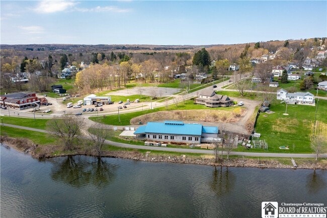
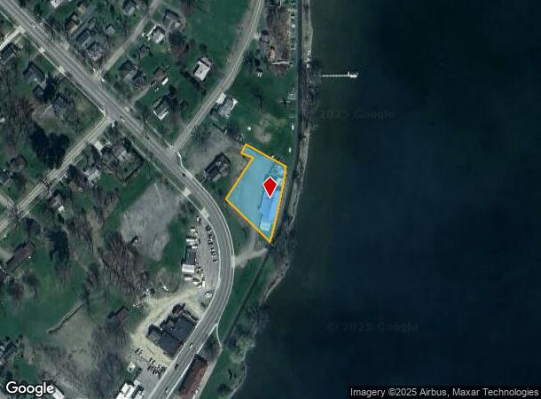
188 S Erie St
Jamestown-Dunkirk-Fredonia, NY
WATERMARK RESTAURANT; OLD APN: 062801 106-7-2
062801-262-012-0003-010-000
Chautauqua
Restaurantbuilding
New York
2025
10.000
2024
0.71 AC
036401
New York West Area
5,500 SF
Other Market Areas
DEMOGRAPHICS near 188 S Erie St
1 Mile
3 Mile
5 Mile
2024 Total Population
1,596
3,914
6,096
2029 Population
1,667
4,217
6,584
Pop Growth 2024-2029
+ 4.45%
+ 7.74%
+ 8.01%
Average Age
45
47
47
2024 Total Households
665
1,704
2,681
HH Growth 2024-2029
+ 5.41%
+ 8.57%
+ 8.69%
Median Household Inc
$52,619
$52,474
$47,500
Avg Household Size
2.00
2.10
2.10
2024 Avg HH Vehicles
2.00
2.00
2.00
Median Home Value
$134,000
$169,973
$180,216
Median Year Built
1960
1967
1967
Nearby Places
- Restaurants
- Banks
- Shops
- Fitness
- Groceries
Nearby Properties
Address
Land Use
TOTAL SIZE
Lot Size
Zoning
Address
Land Use
TOTAL SIZE
Lot Size
Zoning
278,403 SF
109.60 AC
04
Address
Land Use
TOTAL SIZE
Lot Size
Zoning
104,328 SF
5.40 AC
04 - FARM
Address
Land Use
TOTAL SIZE
Lot Size
Zoning
5,204 SF
3.70 AC
07 - MIXED
Address
Land Use
TOTAL SIZE
Lot Size
Zoning
46,074 SF
17.40 AC
03 - MULTI
Address
Land Use
TOTAL SIZE
Lot Size
Zoning
0.01 AC
Address
Land Use
TOTAL SIZE
Lot Size
Zoning
65,790 SF
1.82 AC
05 - COMME
Address
Land Use
TOTAL SIZE
Lot Size
Zoning
4,944 SF
0.44 AC
07 - MIXED
Address
Land Use
TOTAL SIZE
Lot Size
Zoning
40,716 SF
0.60 AC
05 - COMME
Address
Land Use
TOTAL SIZE
Lot Size
Zoning
0.42 AC
05 - COMME
Address
Land Use
TOTAL SIZE
Lot Size
Zoning
29,157 SF
2.30 AC
07 - MIXED
Address
Land Use
TOTAL SIZE
Lot Size
Zoning
46,452 SF
2.50 AC
07 - MIXED
Address
Land Use
TOTAL SIZE
Lot Size
Zoning
0.01 AC
Address
Land Use
TOTAL SIZE
Lot Size
Zoning
156 SF
4.50 AC
07
Address
Land Use
TOTAL SIZE
Lot Size
Zoning
20,516 SF
0.68 AC
05 - COMME
Address
Land Use
TOTAL SIZE
Lot Size
Zoning
4,311 SF
0.07 AC
07 - MIXED
Address
Land Use
TOTAL SIZE
Lot Size
Zoning
1,152 SF
4.80 AC
07 - MIXED
Address
Land Use
TOTAL SIZE
Lot Size
Zoning
18,168 SF
3.80 AC
07 - MIXED
Address
Land Use
TOTAL SIZE
Lot Size
Zoning
3,300 SF
13.73 AC
05 - COMME
Address
Land Use
TOTAL SIZE
Lot Size
Zoning
4,640 SF
0.78 AC
07 - MIXED
Address
Land Use
TOTAL SIZE
Lot Size
Zoning
5,668 SF
2.80 AC
07 - MIXED
Address
Land Use
TOTAL SIZE
Lot Size
Zoning
8,619 SF
0.33 AC
07 - MIXED
Address
Land Use
TOTAL SIZE
Lot Size
Zoning
Address
Land Use
TOTAL SIZE
Lot Size
Zoning
21,875 SF
14.40 AC
05 - COMME
Address
Land Use
TOTAL SIZE
Lot Size
Zoning
41,581 SF
9.90 AC
04 - FARM
Address
Land Use
TOTAL SIZE
Lot Size
Zoning
0.01 AC
Address
Land Use
TOTAL SIZE
Lot Size
Zoning
1 AC
07 - MIXED
Address
Land Use
TOTAL SIZE
Lot Size
Zoning
21,112 SF
0.61 AC
05 - COMME
Address
Land Use
TOTAL SIZE
Lot Size
Zoning
0.01 AC
Address
Land Use
TOTAL SIZE
Lot Size
Zoning
6,000 SF
1.40 AC
02 - SINGL
Address
Land Use
TOTAL SIZE
Lot Size
Zoning
4,062 SF
0.59 AC
05 - COMME
The World's #1 Commercial Real Estate Marketplace
Connect with us
© 2025 CoStar Group
The information above has been obtained from sources believed reliable. While we do not doubt its accuracy we have not verified it and make no guarantee, warranty or representation about it. It is your responsibility to independently confirm its accuracy and completeness. Any projections, opinions, assumptions, or estimates used are for example only and do not represent the current or future performance of the property. The value of this transaction to you depends on tax and other factors which should be evaluated by your tax, financial, and legal advisors. You and your advisors should conduct a careful, independent investigation of the property to determine to your satisfaction the suitability of the property for your needs.