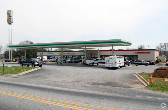
Property Record
1880 Highway 14 E, Landrum, SC 29356

Property Detail
1880 Highway 14 E
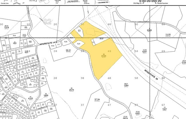
1-08-00-036.00
S SIDE SC HWY 14 & W SIDE I-26 FORMERLY BUTLER`S FUELS INC PB 158-998 PB 162-740 DB 84N-878 DB 90T-4
Commercialnec
Spartanburg
B and X Area of moderate flood hazard, usually the area between the limits of the 100-year and 500-year floods.
South Carolina
0
2 AC
2025
Upper Spartanburg Cty
022600
Greenville/Spartanburg
13,661 SF
Spartanburg, SC
NEARBY LISTINGS FOR SALE OR LEASE
DEMOGRAPHICS near 1880 Highway 14 E
1 mile
3 mile
5 mile
2025 Total Population
837
5,890
15,708
2030 Population
936
6,534
17,121
Pop Growth 2025-2030
+ 11.83%
+ 10.93%
+ 9.00%
Average Age
45
45
47
2025 Total Households
375
2,542
6,733
HH Growth 2025-2030
+ 11.73%
+ 10.98%
+ 8.91%
Median Household Inc
$40,865
$51,040
$59,085
Avg Household Size
2.20
2.30
2.30
2025 Avg HH Vehicles
2.00
2.00
2.00
Median Home Value
$241,304
$283,688
$325,824
Median Year Built
1974
1979
1984
Nearby Places
Map Layers
Map Styles
 Street
 Aerial
Layers
 Traffic
 Biking
Places
Listings with unknown addresses are not visible on the map
- Restaurants
- Banks
- Shops
- Fitness
- Groceries
PUBLIC TRANSPORTATION
AIRPORT
Greenville Spartanburg International
Drive
Walk
Distance
Greenville Spartanburg International
40 min
32.1 mi
Asheville Regional
Drive
Walk
Distance
Asheville Regional
40 min
32.3 mi
Nearby Properties
Address
Land Use
TOTAL SIZE
Lot Size
Zoning
Address
Land Use
TOTAL SIZE
Lot Size
Zoning
166.74 AC
RE5
Address
Land Use
TOTAL SIZE
Lot Size
Zoning
7,703 SF
190.87 AC
RE5
Address
Land Use
TOTAL SIZE
Lot Size
Zoning
332.64 AC
Address
Land Use
TOTAL SIZE
Lot Size
Zoning
9,745 SF
10.01 AC
Address
Land Use
TOTAL SIZE
Lot Size
Zoning
2,290 SF
23.19 AC
RE5
Address
Land Use
TOTAL SIZE
Lot Size
Zoning
1,064 SF
12.44 AC
MX
Address
Land Use
TOTAL SIZE
Lot Size
Zoning
2,812 SF
3.26 AC
RE5
Address
Land Use
TOTAL SIZE
Lot Size
Zoning
13.05 AC
Address
Land Use
TOTAL SIZE
Lot Size
Zoning
3,352 SF
7.54 AC
MX
Address
Land Use
TOTAL SIZE
Lot Size
Zoning
2.43 AC
MX
Address
Land Use
TOTAL SIZE
Lot Size
Zoning
15.18 AC
Address
Land Use
TOTAL SIZE
Lot Size
Zoning
4.61 AC
RE5
Address
Land Use
TOTAL SIZE
Lot Size
Zoning
1,822 SF
12.75 AC
MX
Address
Land Use
TOTAL SIZE
Lot Size
Zoning
2.59 AC
Address
Land Use
TOTAL SIZE
Lot Size
Zoning
2.20 AC
MX
Address
Land Use
TOTAL SIZE
Lot Size
Zoning
21.61 AC
RE5
Address
Land Use
TOTAL SIZE
Lot Size
Zoning
1,410 SF
31.21 AC
RE5
Address
Land Use
TOTAL SIZE
Lot Size
Zoning
1,065 SF
32.46 AC
RE5
Address
Land Use
TOTAL SIZE
Lot Size
Zoning
Address
Land Use
TOTAL SIZE
Lot Size
Zoning
1,380 SF
30.08 AC
AR5
Address
Land Use
TOTAL SIZE
Lot Size
Zoning
1,584 SF
8.79 AC
RE5
Address
Land Use
TOTAL SIZE
Lot Size
Zoning
19.25 AC
RE5
Address
Land Use
TOTAL SIZE
Lot Size
Zoning
2.70 AC
MX
Address
Land Use
TOTAL SIZE
Lot Size
Zoning
22.88 AC
RE5
Address
Land Use
TOTAL SIZE
Lot Size
Zoning
8.65 AC
RE5
Address
Land Use
TOTAL SIZE
Lot Size
Zoning
5.24 AC
RE5
Address
Land Use
TOTAL SIZE
Lot Size
Zoning
8.57 AC
RE5
Address
Land Use
TOTAL SIZE
Lot Size
Zoning
1,991 SF
2.10 AC
MX
Address
Land Use
TOTAL SIZE
Lot Size
Zoning
3.64 AC
MX
Address
Land Use
TOTAL SIZE
Lot Size
Zoning
2.54 AC
MX
The World's #1 Commercial Real Estate Marketplace
Connect with us
© 2026 CoStar Group
The information above has been obtained from sources believed reliable. While we do not doubt its accuracy we have not verified it and make no guarantee, warranty or representation about it. It is your responsibility to independently confirm its accuracy and completeness. Any projections, opinions, assumptions, or estimates used are for example only and do not represent the current or future performance of the property. The value of this transaction to you depends on tax and other factors which should be evaluated by your tax, financial, and legal advisors. You and your advisors should conduct a careful, independent investigation of the property to determine to your satisfaction the suitability of the property for your needs.