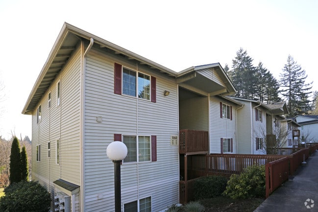
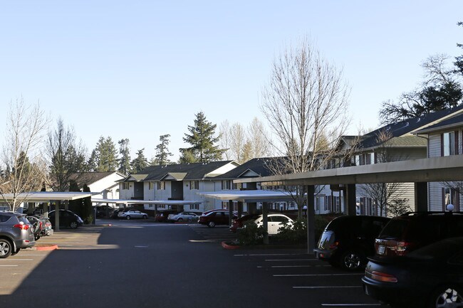
Property Record
1880 Rees Hill Rd Se, Salem, OR 97306


Property Detail
1880 Rees Hill Rd Se
572012
PP 1999-005 LOT 2 ACRES 4.65
Multifamilydwelling
Marion
RM2
Oregon
B and X Area of moderate flood hazard, usually the area between the limits of the 100-year and 500-year floods.
2
2024
4.65 AC
2025
South Gateway
002800
Portland
37,115 SF
Salem, OR
NEARBY LISTINGS FOR SALE OR LEASE
DEMOGRAPHICS near 1880 Rees Hill Rd Se
1 mile
3 mile
5 mile
2024 Total Population
9,088
44,201
91,478
2029 Population
9,197
44,777
92,509
Pop Growth 2024-2029
+ 1.20%
+ 1.30%
+ 1.13%
Average Age
40
41
41
2024 Total Households
3,725
16,122
34,657
HH Growth 2024-2029
+ 1.23%
+ 1.36%
+ 1.21%
Median Household Inc
$74,920
$92,751
$84,942
Avg Household Size
2.40
2.50
2.50
2024 Avg HH Vehicles
2.00
2.00
2.00
Median Home Value
$443,516
$475,254
$466,710
Median Year Built
1992
1991
1982
Nearby Places
Map Layers
Map Styles
 Street
 Aerial
Transit
 Traffic
 Biking
Places
Listings with unknown addresses are not visible on the map
- Restaurants
- Banks
- Shops
- Fitness
- Groceries
PUBLIC TRANSPORTATION
COMMUTER RAIL
Salem (Amtrak Cascades - Amtrak, Coast Starlight - Amtrak)
Drive
Walk
Distance
Salem (Amtrak Cascades - Amtrak, Coast Starlight - Amtrak)
11 min
5.8 mi
Freight Ports
Port of Portland
Drive
Walk
Distance
Port of Portland
74 min
56.5 mi
Nearby Properties
Address
Land Use
TOTAL SIZE
Lot Size
Zoning
Address
Land Use
TOTAL SIZE
Lot Size
Zoning
158,880 SF
8.80 AC
RM2; RM1;
Address
Land Use
TOTAL SIZE
Lot Size
Zoning
114,647 SF
5.72 AC
RM2; RM1
Address
Land Use
TOTAL SIZE
Lot Size
Zoning
193,237 SF
9.98 AC
IG
Address
Land Use
TOTAL SIZE
Lot Size
Zoning
1,769,016 SF
20.58 AC
CR
Address
Land Use
TOTAL SIZE
Lot Size
Zoning
204,178 SF
10.43 AC
RM2; PA
Address
Land Use
TOTAL SIZE
Lot Size
Zoning
118,239 SF
10.69 AC
IG
Address
Land Use
TOTAL SIZE
Lot Size
Zoning
74,710 SF
9.83 AC
PS
Address
Land Use
TOTAL SIZE
Lot Size
Zoning
72,325 SF
7.79 AC
IBC
Address
Land Use
TOTAL SIZE
Lot Size
Zoning
144,616 SF
7.07 AC
RM2; CO
Address
Land Use
TOTAL SIZE
Lot Size
Zoning
174,632 SF
4.58 AC
CO
Address
Land Use
TOTAL SIZE
Lot Size
Zoning
120,648 SF
16.05 AC
CR
Address
Land Use
TOTAL SIZE
Lot Size
Zoning
124,947 SF
6.27 AC
RM2
Address
Land Use
TOTAL SIZE
Lot Size
Zoning
109,373 SF
4.30 AC
FMU
Address
Land Use
TOTAL SIZE
Lot Size
Zoning
115,612 SF
5.87 AC
RM2
Address
Land Use
TOTAL SIZE
Lot Size
Zoning
132,655 SF
6.78 AC
FMU
Address
Land Use
TOTAL SIZE
Lot Size
Zoning
51,473 SF
5.01 AC
CO
Address
Land Use
TOTAL SIZE
Lot Size
Zoning
114,559 SF
5.26 AC
RM2
Address
Land Use
TOTAL SIZE
Lot Size
Zoning
55,583 SF
8 AC
IC
Address
Land Use
TOTAL SIZE
Lot Size
Zoning
Address
Land Use
TOTAL SIZE
Lot Size
Zoning
80,172 SF
8.56 AC
IBC
Address
Land Use
TOTAL SIZE
Lot Size
Zoning
53,822 SF
3.50 AC
CR
Address
Land Use
TOTAL SIZE
Lot Size
Zoning
62,413 SF
4.91 AC
CR
Address
Land Use
TOTAL SIZE
Lot Size
Zoning
83,885 SF
4.22 AC
CR
Address
Land Use
TOTAL SIZE
Lot Size
Zoning
57,933 SF
5.29 AC
CR; RS
Address
Land Use
TOTAL SIZE
Lot Size
Zoning
106,010 SF
6.21 AC
RM2; RM1
Address
Land Use
TOTAL SIZE
Lot Size
Zoning
59,705 SF
10.08 AC
UT-10
Address
Land Use
TOTAL SIZE
Lot Size
Zoning
110,200 SF
5.19 AC
RM2
Address
Land Use
TOTAL SIZE
Lot Size
Zoning
96,322 SF
5.12 AC
RM2
Address
Land Use
TOTAL SIZE
Lot Size
Zoning
89,970 SF
4.39 AC
RM2
The World's #1 Commercial Real Estate Marketplace
Connect with us
© 2026 CoStar Group
The information above has been obtained from sources believed reliable. While we do not doubt its accuracy we have not verified it and make no guarantee, warranty or representation about it. It is your responsibility to independently confirm its accuracy and completeness. Any projections, opinions, assumptions, or estimates used are for example only and do not represent the current or future performance of the property. The value of this transaction to you depends on tax and other factors which should be evaluated by your tax, financial, and legal advisors. You and your advisors should conduct a careful, independent investigation of the property to determine to your satisfaction the suitability of the property for your needs.