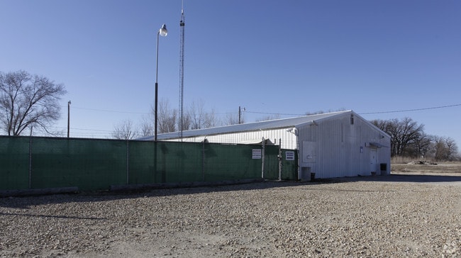
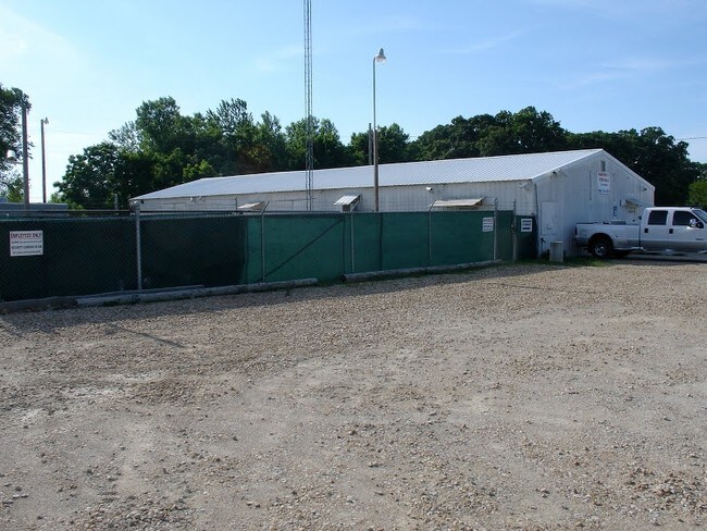
Property Record
1881 E 1450 Rd, Lawrence, KS 66044

Property Detail
1881 E 1450 Rd
0741800000036000
1A 18-12-20 BEG 903.37 FT S OFNE COR NW 1/4 18-12-20 TH W 189.25 FT TO E R/W UPRR TH SW ALONG RR R/W 221.47 FT TH E 202.7 FT
Officebuilding
Douglas
I2
Kansas
2025
1 AC
2025
Lawrence
000100
Kansas City
3,876 SF
Lawrence, KS
NEARBY LISTINGS FOR SALE OR LEASE
DEMOGRAPHICS near 1881 E 1450 Rd
1 mile
3 mile
5 mile
2025 Total Population
49
11,568
61,418
2030 Population
52
11,825
62,837
Pop Growth 2025-2030
+ 6.12%
+ 2.22%
+ 2.31%
Average Age
42
40
36
2025 Total Households
19
5,153
25,213
HH Growth 2025-2030
0.00%
+ 2.45%
+ 2.63%
Median Household Inc
$65,000
$69,234
$60,687
Avg Household Size
2.30
2.20
2.10
2025 Avg HH Vehicles
2.00
2.00
2.00
Median Home Value
$299,999
$258,633
$276,729
Median Year Built
1997
1980
1979
Nearby Places
Map Layers
Map Styles
 Street
 Aerial
Transit
 Traffic
 Biking
Places
Listings with unknown addresses are not visible on the map
- Restaurants
- Banks
- Shops
- Fitness
- Groceries
PUBLIC TRANSPORTATION
COMMUTER RAIL
Drive
Walk
Distance
6 min
3.2 mi
AIRPORT
Kansas City International
Drive
Walk
Distance
Kansas City International
57 min
49.8 mi
Nearby Properties
Address
Land Use
TOTAL SIZE
Lot Size
Zoning
Address
Land Use
TOTAL SIZE
Lot Size
Zoning
63,837 SF
20.79 AC
H
Address
Land Use
TOTAL SIZE
Lot Size
Zoning
112,500 SF
3.90 AC
RM1
Address
Land Use
TOTAL SIZE
Lot Size
Zoning
47,457 SF
2.58 AC
Address
Land Use
TOTAL SIZE
Lot Size
Zoning
31,750 SF
0.73 AC
Address
Land Use
TOTAL SIZE
Lot Size
Zoning
2,728 SF
305 AC
RS1
Address
Land Use
TOTAL SIZE
Lot Size
Zoning
24,600 SF
8.90 AC
M3
Address
Land Use
TOTAL SIZE
Lot Size
Zoning
53,064 SF
5.79 AC
M2
Address
Land Use
TOTAL SIZE
Lot Size
Zoning
53,678 SF
9.40 AC
RS2
Address
Land Use
TOTAL SIZE
Lot Size
Zoning
47,152 SF
4.16 AC
RS2
Address
Land Use
TOTAL SIZE
Lot Size
Zoning
5,506 SF
6.10 AC
Address
Land Use
TOTAL SIZE
Lot Size
Zoning
35,209 SF
4.56 AC
O1
Address
Land Use
TOTAL SIZE
Lot Size
Zoning
21,856 SF
0.86 AC
RO1
Address
Land Use
TOTAL SIZE
Lot Size
Zoning
48,077 SF
8.70 AC
RS2
Address
Land Use
TOTAL SIZE
Lot Size
Zoning
25,503 SF
4.50 AC
C4
Address
Land Use
TOTAL SIZE
Lot Size
Zoning
16,013 SF
Address
Land Use
TOTAL SIZE
Lot Size
Zoning
62,756 SF
7.20 AC
M2
Address
Land Use
TOTAL SIZE
Lot Size
Zoning
944,874 SF
49.40 AC
M2
Address
Land Use
TOTAL SIZE
Lot Size
Zoning
51,058 SF
4.50 AC
RS2
Address
Land Use
TOTAL SIZE
Lot Size
Zoning
15,008 SF
3.20 AC
M2
Address
Land Use
TOTAL SIZE
Lot Size
Zoning
18,000 SF
13 AC
M2
Address
Land Use
TOTAL SIZE
Lot Size
Zoning
346,149 SF
24.51 AC
M2
Address
Land Use
TOTAL SIZE
Lot Size
Zoning
20,732 SF
2.61 AC
RO2
Address
Land Use
TOTAL SIZE
Lot Size
Zoning
2,928 SF
32.50 AC
RS2
Address
Land Use
TOTAL SIZE
Lot Size
Zoning
300,750 SF
40.17 AC
M2
Address
Land Use
TOTAL SIZE
Lot Size
Zoning
3.44 AC
RS2
Address
Land Use
TOTAL SIZE
Lot Size
Zoning
233,780 SF
20.50 AC
M2
Address
Land Use
TOTAL SIZE
Lot Size
Zoning
319,280 SF
62 AC
M2
Address
Land Use
TOTAL SIZE
Lot Size
Zoning
9,200 SF
10.96 AC
M2
Address
Land Use
TOTAL SIZE
Lot Size
Zoning
20,800 SF
1.72 AC
C3
Address
Land Use
TOTAL SIZE
Lot Size
Zoning
16,000 SF
1.48 AC
PCD1
The World's #1 Commercial Real Estate Marketplace
Connect with us
© 2026 CoStar Group
The information above has been obtained from sources believed reliable. While we do not doubt its accuracy we have not verified it and make no guarantee, warranty or representation about it. It is your responsibility to independently confirm its accuracy and completeness. Any projections, opinions, assumptions, or estimates used are for example only and do not represent the current or future performance of the property. The value of this transaction to you depends on tax and other factors which should be evaluated by your tax, financial, and legal advisors. You and your advisors should conduct a careful, independent investigation of the property to determine to your satisfaction the suitability of the property for your needs.