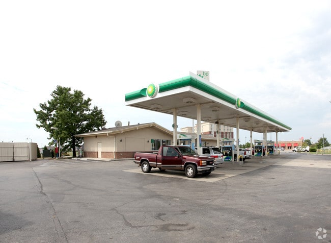
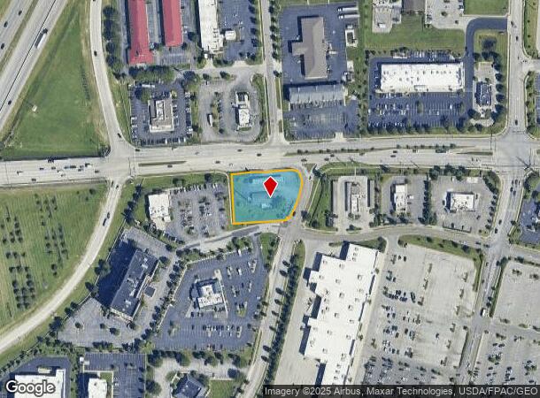
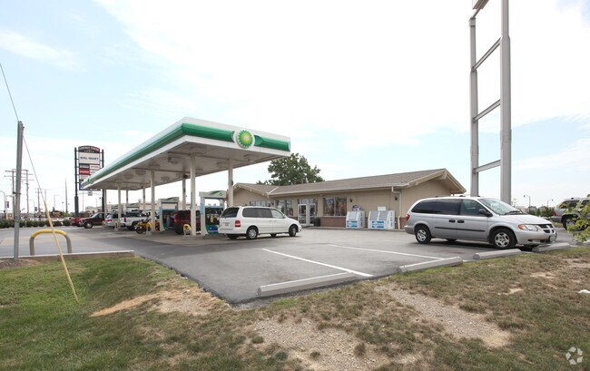
Property Record
1881 Stringtown Rd, Grove City, OH 43123
NEARBY LISTINGS FOR SALE OR LEASE
Property Detail
1881 Stringtown Rd
Columbus, OH
Virginia Military Survey #8231
040-005962
1881 STRINGTOWN ROAD ENTRY 8231 0.872 ACRE
Servicestation
Franklin
2024
Ohio
2024
0.87 AC
009755
Southwest
2,610 SF
Columbus
DEMOGRAPHICS near 1881 Stringtown Rd
1 Mile
3 Mile
5 Mile
2024 Total Population
4,966
53,147
145,196
2029 Population
4,980
53,392
145,671
Pop Growth 2024-2029
+ 0.28%
+ 0.46%
+ 0.33%
Average Age
43
40
39
2024 Total Households
2,162
20,597
55,678
HH Growth 2024-2029
+ 0.23%
+ 0.44%
+ 0.30%
Median Household Inc
$90,456
$77,647
$65,892
Avg Household Size
2.20
2.50
2.50
2024 Avg HH Vehicles
2.00
2.00
2.00
Median Home Value
$327,203
$232,048
$189,307
Median Year Built
2003
1991
1975
Nearby Places
Map Layers
Map Styles
 Street
 Aerial
- Restaurants
- Banks
- Shops
- Fitness
- Groceries
PUBLIC TRANSPORTATION
AIRPORT
Rickenbacker International
DRIVE
WALK
Distance
Rickenbacker International
18 min
11.2 mi
John Glenn Columbus International
DRIVE
WALK
Distance
John Glenn Columbus International
23 min
14.9 mi
Freight Ports
Port of Toledo
DRIVE
WALK
Distance
Port of Toledo
192 min
151.0 mi
Nearby Properties
Address
Land Use
TOTAL SIZE
Lot Size
Zoning
Address
Land Use
TOTAL SIZE
Lot Size
Zoning
844,679 SF
61.71 AC
Address
Land Use
TOTAL SIZE
Lot Size
Zoning
382.42 AC
Address
Land Use
TOTAL SIZE
Lot Size
Zoning
587,462 SF
480.43 AC
Address
Land Use
TOTAL SIZE
Lot Size
Zoning
1,058 SF
0.03 AC
Address
Land Use
TOTAL SIZE
Lot Size
Zoning
125,467 SF
20.61 AC
Address
Land Use
TOTAL SIZE
Lot Size
Zoning
928,228 SF
39.80 AC
Address
Land Use
TOTAL SIZE
Lot Size
Zoning
170,028 SF
13.66 AC
Address
Land Use
TOTAL SIZE
Lot Size
Zoning
128,263 SF
6.59 AC
Address
Land Use
TOTAL SIZE
Lot Size
Zoning
169,252 SF
22.06 AC
Address
Land Use
TOTAL SIZE
Lot Size
Zoning
227,844 SF
21.57 AC
Address
Land Use
TOTAL SIZE
Lot Size
Zoning
493,000 SF
29.55 AC
Address
Land Use
TOTAL SIZE
Lot Size
Zoning
322,000 SF
22.14 AC
Address
Land Use
TOTAL SIZE
Lot Size
Zoning
408,294 SF
26.64 AC
Address
Land Use
TOTAL SIZE
Lot Size
Zoning
322,000 SF
18.83 AC
Address
Land Use
TOTAL SIZE
Lot Size
Zoning
542,043 SF
30.41 AC
Address
Land Use
TOTAL SIZE
Lot Size
Zoning
404,812 SF
41.33 AC
Address
Land Use
TOTAL SIZE
Lot Size
Zoning
227,576 SF
52.33 AC
Address
Land Use
TOTAL SIZE
Lot Size
Zoning
399,784 SF
20.86 AC
Address
Land Use
TOTAL SIZE
Lot Size
Zoning
60,893 SF
19.92 AC
Address
Land Use
TOTAL SIZE
Lot Size
Zoning
137,488 SF
13.44 AC
Address
Land Use
TOTAL SIZE
Lot Size
Zoning
227,826 SF
15.68 AC
Address
Land Use
TOTAL SIZE
Lot Size
Zoning
132,379 SF
15.46 AC
Address
Land Use
TOTAL SIZE
Lot Size
Zoning
61,595 SF
9.75 AC
Address
Land Use
TOTAL SIZE
Lot Size
Zoning
36,877 SF
21.13 AC
Address
Land Use
TOTAL SIZE
Lot Size
Zoning
221,616 SF
10.62 AC
Address
Land Use
TOTAL SIZE
Lot Size
Zoning
81,687 SF
10.19 AC
Address
Land Use
TOTAL SIZE
Lot Size
Zoning
110,447 SF
28.14 AC
Address
Land Use
TOTAL SIZE
Lot Size
Zoning
75,164 SF
16.26 AC
Address
Land Use
TOTAL SIZE
Lot Size
Zoning
111,076 SF
15.98 AC
Address
Land Use
TOTAL SIZE
Lot Size
Zoning
110,694 SF
2.64 AC
The World's #1 Commercial Real Estate Marketplace
Connect with us
© 2025 CoStar Group
The information above has been obtained from sources believed reliable. While we do not doubt its accuracy we have not verified it and make no guarantee, warranty or representation about it. It is your responsibility to independently confirm its accuracy and completeness. Any projections, opinions, assumptions, or estimates used are for example only and do not represent the current or future performance of the property. The value of this transaction to you depends on tax and other factors which should be evaluated by your tax, financial, and legal advisors. You and your advisors should conduct a careful, independent investigation of the property to determine to your satisfaction the suitability of the property for your needs.