Property Record
1881 Whittaker Rd, Ypsilanti, MI 48197
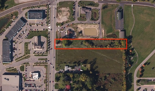
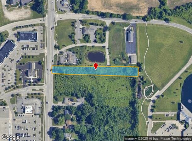
This Property Is For Sale
NEARBY LISTINGS FOR SALE OR LEASE
Property Detail
1881 Whittaker Rd
11-21-200-010
YP#21-8M COM AT SW COR OF SEC, TH N 0 DEG 17' 30 W 3000.5 FT IN W LINE OF SEC
Residentialacreage
Washtenaw
X
Michigan
26161C0430E
1.33 AC
0
Washtenaw E of 23
2025
Detroit
412700
Ann Arbor, MI
DEMOGRAPHICS near 1881 Whittaker Rd
1 Mile
3 Mile
5 Mile
2024 Total Population
1,531
66,282
123,313
2029 Population
1,512
65,457
121,879
Pop Growth 2024-2029
(1.24%)
(1.24%)
(1.16%)
Average Age
41
37
38
2024 Total Households
606
27,254
50,894
HH Growth 2024-2029
(1.32%)
(1.36%)
(1.33%)
Median Household Inc
$99,499
$61,117
$59,598
Avg Household Size
2.40
2.30
2.30
2024 Avg HH Vehicles
2.00
2.00
2.00
Median Home Value
$252,197
$206,842
$213,547
Median Year Built
1977
1972
1976
Nearby Places
- Restaurants
- Banks
- Shops
- Fitness
- Groceries
PUBLIC TRANSPORTATION
AIRPORT
Detroit Metro Wayne County
DRIVE
WALK
Distance
Detroit Metro Wayne County
23 min
17.6 mi
Freight Ports
Port of Toledo
DRIVE
WALK
Distance
Port of Toledo
73 min
59.2 mi
Nearby Properties
Address
Land Use
TOTAL SIZE
Lot Size
Zoning
Address
Land Use
TOTAL SIZE
Lot Size
Zoning
38,001 SF
177.04 AC
BA
Address
Land Use
TOTAL SIZE
Lot Size
Zoning
17,672 SF
33.37 AC
BI
Address
Land Use
TOTAL SIZE
Lot Size
Zoning
27,603 SF
35.42 AC
BI
Address
Land Use
TOTAL SIZE
Lot Size
Zoning
13,224 SF
24.30 AC
BI
Address
Land Use
TOTAL SIZE
Lot Size
Zoning
97.69 AC
Address
Land Use
TOTAL SIZE
Lot Size
Zoning
18,110 SF
14.80 AC
BI
Address
Land Use
TOTAL SIZE
Lot Size
Zoning
1,344 SF
18.17 AC
SPLIT
Address
Land Use
TOTAL SIZE
Lot Size
Zoning
26,146 SF
7.35 AC
BI
Address
Land Use
TOTAL SIZE
Lot Size
Zoning
12,747 SF
22.86 AC
BA
Address
Land Use
TOTAL SIZE
Lot Size
Zoning
19,692 SF
21.22 AC
BA
Address
Land Use
TOTAL SIZE
Lot Size
Zoning
6,192 SF
19.02 AC
BA
Address
Land Use
TOTAL SIZE
Lot Size
Zoning
32,974 SF
29.96 AC
BA
Address
Land Use
TOTAL SIZE
Lot Size
Zoning
11,630 SF
17.36 AC
BA
Address
Land Use
TOTAL SIZE
Lot Size
Zoning
259,778 SF
25.39 AC
Address
Land Use
TOTAL SIZE
Lot Size
Zoning
48,756 SF
5 AC
CN
Address
Land Use
TOTAL SIZE
Lot Size
Zoning
12,747 SF
17.90 AC
BA
Address
Land Use
TOTAL SIZE
Lot Size
Zoning
124,513 SF
3.79 AC
GC
Address
Land Use
TOTAL SIZE
Lot Size
Zoning
1,960 SF
59.97 AC
Address
Land Use
TOTAL SIZE
Lot Size
Zoning
103,997 SF
4.05 AC
SPLIT
Address
Land Use
TOTAL SIZE
Lot Size
Zoning
69,790 SF
6.35 AC
II
Address
Land Use
TOTAL SIZE
Lot Size
Zoning
Address
Land Use
TOTAL SIZE
Lot Size
Zoning
19,008 SF
9.68 AC
Address
Land Use
TOTAL SIZE
Lot Size
Zoning
1,913 SF
23.63 AC
BA
Address
Land Use
TOTAL SIZE
Lot Size
Zoning
11.42 AC
Address
Land Use
TOTAL SIZE
Lot Size
Zoning
76,719 SF
11.69 AC
HHS
Address
Land Use
TOTAL SIZE
Lot Size
Zoning
4,636 SF
18.91 AC
Address
Land Use
TOTAL SIZE
Lot Size
Zoning
3.87 AC
R-4
Address
Land Use
TOTAL SIZE
Lot Size
Zoning
Address
Land Use
TOTAL SIZE
Lot Size
Zoning
79,744 SF
5.39 AC
Address
Land Use
TOTAL SIZE
Lot Size
Zoning
12,747 SF
7.37 AC
BA
The World's #1 Commercial Real Estate Marketplace
Connect with us
© 2025 CoStar Group
The information above has been obtained from sources believed reliable. While we do not doubt its accuracy we have not verified it and make no guarantee, warranty or representation about it. It is your responsibility to independently confirm its accuracy and completeness. Any projections, opinions, assumptions, or estimates used are for example only and do not represent the current or future performance of the property. The value of this transaction to you depends on tax and other factors which should be evaluated by your tax, financial, and legal advisors. You and your advisors should conduct a careful, independent investigation of the property to determine to your satisfaction the suitability of the property for your needs.