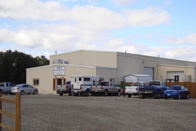
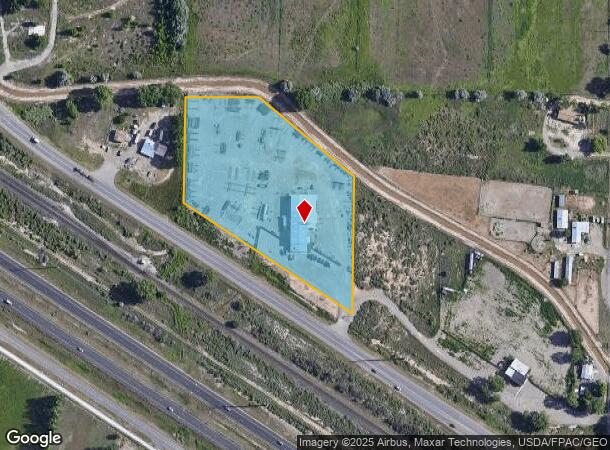
Property Record
1882 Highway 6 And 50, Fruita, CO 81521
NEARBY LISTINGS FOR SALE OR LEASE
-
-
View all Fruita listings for sale on LoopNet.com
Property Detail
1882 Highway 6 And 50
2697-214-00-017
W 5A OF THAT PT OF NE4SE4 SEC 21 1N 2W UM N OF HWY 50 + S OF INDEPENDENT RANCHMENS CNL - 217800 SF / 5.00 AC (PER ACAD)
Industrialgeneral
Mesa
X
Colorado
08077C0439F
17
2023
5 AC
2024
Colorado Northwest Area
001504
Other Market Areas
11,100 SF
Grand Junction, CO
DEMOGRAPHICS near 1882 Highway 6 And 50
1 Mile
3 Mile
5 Mile
2024 Total Population
991
16,979
24,207
2029 Population
1,044
17,866
25,377
Pop Growth 2024-2029
+ 5.35%
+ 5.22%
+ 4.83%
Average Age
39
41
43
2024 Total Households
364
6,570
9,332
HH Growth 2024-2029
+ 5.22%
+ 5.22%
+ 4.86%
Median Household Inc
$65,735
$69,460
$80,428
Avg Household Size
2.70
2.60
2.60
2024 Avg HH Vehicles
2.00
2.00
2.00
Median Home Value
$376,315
$369,440
$415,522
Median Year Built
2001
1999
1997
Nearby Places
Map Layers
Map Styles
 Street
 Aerial
- Restaurants
- Banks
- Shops
- Fitness
- Groceries
PUBLIC TRANSPORTATION
COMMUTER RAIL
Grand Junction Amtrak Station (California Zephyr - Amtrak)
DRIVE
WALK
Distance
Grand Junction Amtrak Station (California Zephyr - Amtrak)
16 min
9.3 mi
AIRPORT
Grand Junction Regional
DRIVE
WALK
Distance
Grand Junction Regional
16 min
10.9 mi
Freight Ports
Port of Long Beach
DRIVE
WALK
Distance
Port of Long Beach
806 min
780.3 mi
Nearby Properties
Address
Land Use
TOTAL SIZE
Lot Size
Zoning
Address
Land Use
TOTAL SIZE
Lot Size
Zoning
74,301 SF
0.02 AC
Address
Land Use
TOTAL SIZE
Lot Size
Zoning
188,386 SF
39.06 AC
CSR
Address
Land Use
TOTAL SIZE
Lot Size
Zoning
97,809 SF
22.16 AC
Address
Land Use
TOTAL SIZE
Lot Size
Zoning
70,671 SF
12.63 AC
Address
Land Use
TOTAL SIZE
Lot Size
Zoning
57,933 SF
10 AC
CSR
Address
Land Use
TOTAL SIZE
Lot Size
Zoning
58,696 SF
8.37 AC
Address
Land Use
TOTAL SIZE
Lot Size
Zoning
60,000 SF
11.50 AC
Address
Land Use
TOTAL SIZE
Lot Size
Zoning
80,543 SF
31.70 AC
AFT
Address
Land Use
TOTAL SIZE
Lot Size
Zoning
46,918 SF
1.08 AC
Address
Land Use
TOTAL SIZE
Lot Size
Zoning
70,981 SF
0.27 AC
Address
Land Use
TOTAL SIZE
Lot Size
Zoning
83,593 SF
4.33 AC
PD
Address
Land Use
TOTAL SIZE
Lot Size
Zoning
69,600 SF
5.72 AC
I-1
Address
Land Use
TOTAL SIZE
Lot Size
Zoning
50,790 SF
9,964.10 AC
TC
Address
Land Use
TOTAL SIZE
Lot Size
Zoning
251,521 SF
0.02 AC
Address
Land Use
TOTAL SIZE
Lot Size
Zoning
16,677 SF
6.75 AC
Address
Land Use
TOTAL SIZE
Lot Size
Zoning
27,000 SF
14.94 AC
GC
Address
Land Use
TOTAL SIZE
Lot Size
Zoning
22,712 SF
3.65 AC
CRS
Address
Land Use
TOTAL SIZE
Lot Size
Zoning
16,257 SF
0.66 AC
Address
Land Use
TOTAL SIZE
Lot Size
Zoning
39,496 SF
2.39 AC
Address
Land Use
TOTAL SIZE
Lot Size
Zoning
50,613 SF
5.07 AC
Address
Land Use
TOTAL SIZE
Lot Size
Zoning
31,236 SF
1.20 AC
TCDD
Address
Land Use
TOTAL SIZE
Lot Size
Zoning
24,495 SF
2.03 AC
Address
Land Use
TOTAL SIZE
Lot Size
Zoning
21,846 SF
4.68 AC
TCDD
Address
Land Use
TOTAL SIZE
Lot Size
Zoning
8.53 AC
Address
Land Use
TOTAL SIZE
Lot Size
Zoning
8.53 AC
Address
Land Use
TOTAL SIZE
Lot Size
Zoning
19,370 SF
4.30 AC
Address
Land Use
TOTAL SIZE
Lot Size
Zoning
14,406 SF
1.77 AC
DCRD
Address
Land Use
TOTAL SIZE
Lot Size
Zoning
26,732 SF
4.75 AC
Address
Land Use
TOTAL SIZE
Lot Size
Zoning
36,139 SF
2.25 AC
GC
Address
Land Use
TOTAL SIZE
Lot Size
Zoning
24,605 SF
1.45 AC
The World's #1 Commercial Real Estate Marketplace
Connect with us
© 2026 CoStar Group
The information above has been obtained from sources believed reliable. While we do not doubt its accuracy we have not verified it and make no guarantee, warranty or representation about it. It is your responsibility to independently confirm its accuracy and completeness. Any projections, opinions, assumptions, or estimates used are for example only and do not represent the current or future performance of the property. The value of this transaction to you depends on tax and other factors which should be evaluated by your tax, financial, and legal advisors. You and your advisors should conduct a careful, independent investigation of the property to determine to your satisfaction the suitability of the property for your needs.