Property Record
1883 N State Highway Cc, Nixa, MO 65714
NEARBY LISTINGS FOR SALE OR LEASE
Property Detail
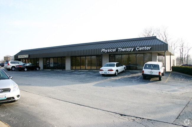
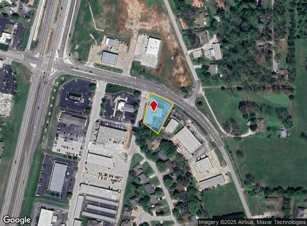
1883 N State Highway Cc
Springfield, MO
James River Plaza
05-0.7-36-003-001-002.000
W1/2 LOT 29 JAMES RIVER PLAZA
Agriculturalland
Christian
X
Missouri
29043C0058D
29
2023
0.34 AC
2024
West Christian County
020202
Springfield
7,200 SF
DEMOGRAPHICS near 1883 N State Highway Cc
1 Mile
3 Mile
5 Mile
2024 Total Population
2,688
33,094
94,856
2029 Population
3,036
36,385
102,174
Pop Growth 2024-2029
+ 12.95%
+ 9.94%
+ 7.71%
Average Age
38
41
41
2024 Total Households
1,041
12,869
38,604
HH Growth 2024-2029
+ 12.97%
+ 10.03%
+ 7.56%
Median Household Inc
$65,723
$79,716
$72,522
Avg Household Size
2.60
2.50
2.40
2024 Avg HH Vehicles
2.00
2.00
2.00
Median Home Value
$217,335
$246,461
$236,809
Median Year Built
1994
1997
1994
Nearby Places
Map Layers
Map Styles
 Street
 Aerial
- Restaurants
- Banks
- Shops
- Fitness
- Groceries
PUBLIC TRANSPORTATION
AIRPORT
Springfield-Branson Ntl
DRIVE
WALK
Distance
Springfield-Branson Ntl
33 min
18.2 mi
Freight Ports
Tulsa Port of Inola
DRIVE
WALK
Distance
Tulsa Port of Inola
196 min
175.8 mi
SALE & LEASE HISTORY
LISTING DATE
SALE/LEASE

Nov 02, 2017
For Lease
Nearby Properties
Address
Land Use
TOTAL SIZE
Lot Size
Zoning
Address
Land Use
TOTAL SIZE
Lot Size
Zoning
26.20 AC
Address
Land Use
TOTAL SIZE
Lot Size
Zoning
141,200 SF
35.65 AC
Address
Land Use
TOTAL SIZE
Lot Size
Zoning
310,792 SF
12.27 AC
Address
Land Use
TOTAL SIZE
Lot Size
Zoning
18.16 AC
Address
Land Use
TOTAL SIZE
Lot Size
Zoning
4.12 AC
INC
Address
Land Use
TOTAL SIZE
Lot Size
Zoning
5.59 AC
INC
Address
Land Use
TOTAL SIZE
Lot Size
Zoning
10,720 SF
9.71 AC
Address
Land Use
TOTAL SIZE
Lot Size
Zoning
39.87 AC
Address
Land Use
TOTAL SIZE
Lot Size
Zoning
126,557 SF
4.62 AC
INC
Address
Land Use
TOTAL SIZE
Lot Size
Zoning
125,218 SF
4.68 AC
INC
Address
Land Use
TOTAL SIZE
Lot Size
Zoning
30,049 SF
5.01 AC
Address
Land Use
TOTAL SIZE
Lot Size
Zoning
73,140 SF
10.80 AC
Address
Land Use
TOTAL SIZE
Lot Size
Zoning
19.78 AC
Address
Land Use
TOTAL SIZE
Lot Size
Zoning
3,080 SF
24.20 AC
Address
Land Use
TOTAL SIZE
Lot Size
Zoning
19,682 SF
7.17 AC
Address
Land Use
TOTAL SIZE
Lot Size
Zoning
13,750 SF
6.56 AC
Address
Land Use
TOTAL SIZE
Lot Size
Zoning
107,194 SF
39.40 AC
Address
Land Use
TOTAL SIZE
Lot Size
Zoning
23,660 SF
10 AC
Address
Land Use
TOTAL SIZE
Lot Size
Zoning
71,436 SF
2.86 AC
INC
Address
Land Use
TOTAL SIZE
Lot Size
Zoning
43,194 SF
18 AC
Address
Land Use
TOTAL SIZE
Lot Size
Zoning
31,570 SF
3.99 AC
Address
Land Use
TOTAL SIZE
Lot Size
Zoning
77,022 SF
9.46 AC
Address
Land Use
TOTAL SIZE
Lot Size
Zoning
13,836 SF
5.81 AC
Address
Land Use
TOTAL SIZE
Lot Size
Zoning
36,110 SF
7 AC
Address
Land Use
TOTAL SIZE
Lot Size
Zoning
22,920 SF
8.51 AC
Address
Land Use
TOTAL SIZE
Lot Size
Zoning
51,498 SF
39.26 AC
Address
Land Use
TOTAL SIZE
Lot Size
Zoning
Address
Land Use
TOTAL SIZE
Lot Size
Zoning
1.44 AC
INC
Address
Land Use
TOTAL SIZE
Lot Size
Zoning
13,940 SF
3.43 AC
Address
Land Use
TOTAL SIZE
Lot Size
Zoning
6,285 SF
1.15 AC
INC
The World's #1 Commercial Real Estate Marketplace
Connect with us
© 2025 CoStar Group
The information above has been obtained from sources believed reliable. While we do not doubt its accuracy we have not verified it and make no guarantee, warranty or representation about it. It is your responsibility to independently confirm its accuracy and completeness. Any projections, opinions, assumptions, or estimates used are for example only and do not represent the current or future performance of the property. The value of this transaction to you depends on tax and other factors which should be evaluated by your tax, financial, and legal advisors. You and your advisors should conduct a careful, independent investigation of the property to determine to your satisfaction the suitability of the property for your needs.