Property Record
18850 Clarke Rd, Parker, CO 80134
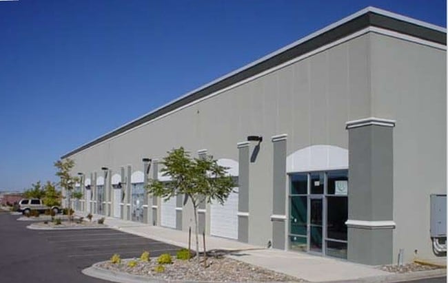

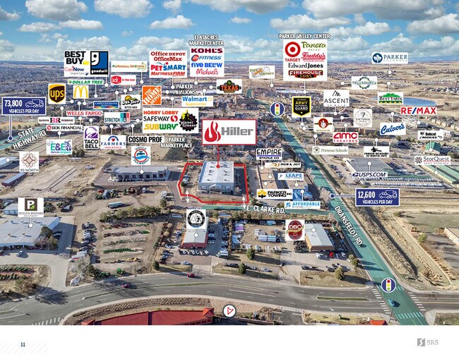

This Property Is For Sale
Property Detail
18850 Clarke Rd
Denver-Aurora-Centennial, CO
LOT 3A MARK SIX BUSINESS SUBDDIVISION 1ST AMD 1.83 AM/L
2233-153-03-024
Douglas
Commercialnec
Colorado
B and X Area of moderate flood hazard, usually the area between the limits of the 100-year and 500-year floods.
3a
2024
1.83 AC
2025
Meridian
013904
Denver
25,520 SF
NEARBY LISTINGS FOR SALE OR LEASE
DEMOGRAPHICS near 18850 Clarke Rd
1 mile
3 mile
5 mile
2025 Total Population
10,440
81,753
132,299
2030 Population
11,237
87,930
141,996
Pop Growth 2025-2030
+ 7.63%
+ 7.56%
+ 7.33%
Average Age
37
38
39
2025 Total Households
4,441
29,371
48,734
HH Growth 2025-2030
+ 7.88%
+ 7.87%
+ 7.44%
Median Household Inc
$87,473
$128,023
$127,253
Avg Household Size
2.30
2.70
2.70
2025 Avg HH Vehicles
2.00
2.00
2.00
Median Home Value
$605,320
$701,489
$719,284
Median Year Built
1998
2003
2004
Nearby Places
Map Layers
Map Styles
 Street
 Aerial
Transit
 Traffic
 Biking
Places
Listings with unknown addresses are not visible on the map
- Restaurants
- Banks
- Shops
- Fitness
- Groceries
PUBLIC TRANSPORTATION
AIRPORT
Denver International
Drive
Walk
Distance
Denver International
34 min
30.2 mi
Nearby Properties
Address
Land Use
TOTAL SIZE
Lot Size
Zoning
Address
Land Use
TOTAL SIZE
Lot Size
Zoning
381,657 SF
33.84 AC
Address
Land Use
TOTAL SIZE
Lot Size
Zoning
207,872 SF
44.94 AC
PDU
Address
Land Use
TOTAL SIZE
Lot Size
Zoning
494,489 SF
22.16 AC
Address
Land Use
TOTAL SIZE
Lot Size
Zoning
93,100 SF
8.78 AC
Address
Land Use
TOTAL SIZE
Lot Size
Zoning
132,601 SF
16.08 AC
Address
Land Use
TOTAL SIZE
Lot Size
Zoning
343,018 SF
15.13 AC
Address
Land Use
TOTAL SIZE
Lot Size
Zoning
344,128 SF
19.06 AC
Address
Land Use
TOTAL SIZE
Lot Size
Zoning
455,049 SF
16.96 AC
Address
Land Use
TOTAL SIZE
Lot Size
Zoning
53,500 SF
6 AC
Address
Land Use
TOTAL SIZE
Lot Size
Zoning
442,567 SF
16.91 AC
Address
Land Use
TOTAL SIZE
Lot Size
Zoning
453,901 SF
16.34 AC
Address
Land Use
TOTAL SIZE
Lot Size
Zoning
445,938 SF
19.85 AC
Address
Land Use
TOTAL SIZE
Lot Size
Zoning
93,100 SF
8.95 AC
Address
Land Use
TOTAL SIZE
Lot Size
Zoning
132,601 SF
16.05 AC
Address
Land Use
TOTAL SIZE
Lot Size
Zoning
375,171 SF
12.88 AC
Address
Land Use
TOTAL SIZE
Lot Size
Zoning
88,280 SF
34.08 AC
A1
Address
Land Use
TOTAL SIZE
Lot Size
Zoning
514,882 SF
18.63 AC
Address
Land Use
TOTAL SIZE
Lot Size
Zoning
389,337 SF
22.01 AC
Address
Land Use
TOTAL SIZE
Lot Size
Zoning
138,348 SF
14.96 AC
RR
Address
Land Use
TOTAL SIZE
Lot Size
Zoning
117,593 SF
37.91 AC
A1
Address
Land Use
TOTAL SIZE
Lot Size
Zoning
74,804 SF
Address
Land Use
TOTAL SIZE
Lot Size
Zoning
369,624 SF
21.98 AC
Address
Land Use
TOTAL SIZE
Lot Size
Zoning
307,904 SF
15.72 AC
Address
Land Use
TOTAL SIZE
Lot Size
Zoning
122,154 SF
13.90 AC
Address
Land Use
TOTAL SIZE
Lot Size
Zoning
75,651 SF
10.02 AC
PDU
Address
Land Use
TOTAL SIZE
Lot Size
Zoning
119,298 SF
11.11 AC
Address
Land Use
TOTAL SIZE
Lot Size
Zoning
88,438 SF
13.72 AC
Address
Land Use
TOTAL SIZE
Lot Size
Zoning
79,907 SF
7.52 AC
Address
Land Use
TOTAL SIZE
Lot Size
Zoning
60,000 SF
9.04 AC
Address
Land Use
TOTAL SIZE
Lot Size
Zoning
73,146 SF
6.91 AC
The World's #1 Commercial Real Estate Marketplace
Connect with us
© 2026 CoStar Group
The information above has been obtained from sources believed reliable. While we do not doubt its accuracy we have not verified it and make no guarantee, warranty or representation about it. It is your responsibility to independently confirm its accuracy and completeness. Any projections, opinions, assumptions, or estimates used are for example only and do not represent the current or future performance of the property. The value of this transaction to you depends on tax and other factors which should be evaluated by your tax, financial, and legal advisors. You and your advisors should conduct a careful, independent investigation of the property to determine to your satisfaction the suitability of the property for your needs.