Property Record
1886 Us Highway 17, Williamston, NC 27892
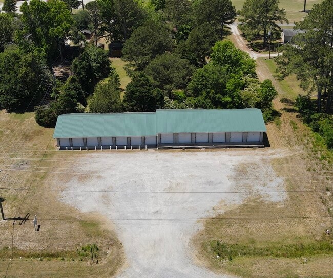
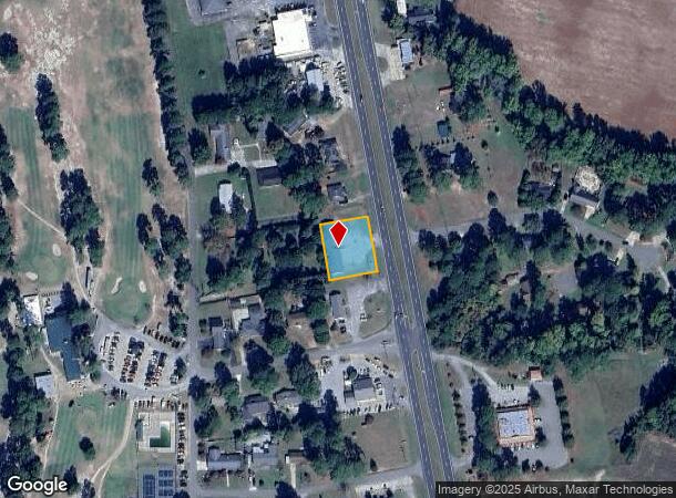
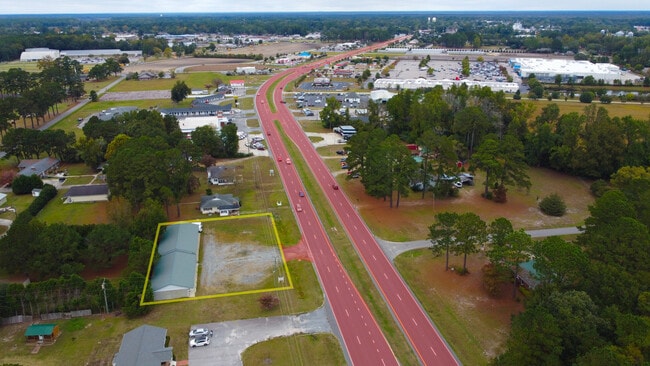
This Property Is For Sale
NEARBY LISTINGS FOR SALE OR LEASE
Property Detail
1886 Us Highway 17
Publicstorage
MINI STG 1886 US HWY
X
Martin
3720577600L
North Carolina
2025
0.51 AC
2025
North Carolina Northeast Area
970200
Other Market Areas
4,794 SF
0505122
DEMOGRAPHICS near 1886 Us Highway 17
1 mile
3 mile
5 mile
2024 Total Population
649
7,776
10,937
2029 Population
642
7,658
10,742
Pop Growth 2024-2029
(1.08%)
(1.52%)
(1.78%)
Average Age
45
44
44
2024 Total Households
292
3,410
4,750
HH Growth 2024-2029
(1.03%)
(1.41%)
(1.64%)
Median Household Inc
$50,500
$39,153
$40,788
Avg Household Size
2.20
2.20
2.20
2024 Avg HH Vehicles
2.00
2.00
2.00
Median Home Value
$188,234
$139,058
$128,062
Median Year Built
1988
1971
1975
Nearby Places
Map Layers
Map Styles
 Street
 Aerial
Transit
 Traffic
 Biking
Places
Listings with unknown addresses are not visible on the map
- Restaurants
- Banks
- Shops
- Fitness
- Groceries
PUBLIC TRANSPORTATION
AIRPORT
Pitt-Greenville
Drive
Walk
Distance
Pitt-Greenville
43 min
34.2 mi
Freight Ports
Port of Morehead City
Drive
Walk
Distance
Port of Morehead City
134 min
96.3 mi
Nearby Properties
Address
Land Use
TOTAL SIZE
Lot Size
Zoning
Address
Land Use
TOTAL SIZE
Lot Size
Zoning
52,360 SF
169.61 AC
A
Address
Land Use
TOTAL SIZE
Lot Size
Zoning
189,224 SF
23.42 AC
Address
Land Use
TOTAL SIZE
Lot Size
Zoning
30.99 AC
Address
Land Use
TOTAL SIZE
Lot Size
Zoning
62,164 SF
21.94 AC
OI
Address
Land Use
TOTAL SIZE
Lot Size
Zoning
53,136 SF
63.38 AC
C
Address
Land Use
TOTAL SIZE
Lot Size
Zoning
21,080 SF
65.94 AC
OI
Address
Land Use
TOTAL SIZE
Lot Size
Zoning
17,872 SF
2.41 AC
C
Address
Land Use
TOTAL SIZE
Lot Size
Zoning
15,305 SF
10.78 AC
CSC
Address
Land Use
TOTAL SIZE
Lot Size
Zoning
13,764 SF
9.34 AC
A
Address
Land Use
TOTAL SIZE
Lot Size
Zoning
60,220 SF
10.49 AC
OI
Address
Land Use
TOTAL SIZE
Lot Size
Zoning
38,137 SF
5.27 AC
C
Address
Land Use
TOTAL SIZE
Lot Size
Zoning
37,600 SF
5.08 AC
C
Address
Land Use
TOTAL SIZE
Lot Size
Zoning
1,680 SF
6.79 AC
R6
Address
Land Use
TOTAL SIZE
Lot Size
Zoning
4,269 SF
8.76 AC
R6
Address
Land Use
TOTAL SIZE
Lot Size
Zoning
33,082 SF
5.89 AC
R6
Address
Land Use
TOTAL SIZE
Lot Size
Zoning
38,800 SF
8.90 AC
CSC
Address
Land Use
TOTAL SIZE
Lot Size
Zoning
Address
Land Use
TOTAL SIZE
Lot Size
Zoning
2,494 SF
16.26 AC
R6
Address
Land Use
TOTAL SIZE
Lot Size
Zoning
14,290 SF
8.27 AC
OI
Address
Land Use
TOTAL SIZE
Lot Size
Zoning
47,405 SF
5.20 AC
R6
Address
Land Use
TOTAL SIZE
Lot Size
Zoning
400 SF
6.24 AC
R6
Address
Land Use
TOTAL SIZE
Lot Size
Zoning
17,119 SF
4.80 AC
R
Address
Land Use
TOTAL SIZE
Lot Size
Zoning
10,440 SF
85.52 AC
A
Address
Land Use
TOTAL SIZE
Lot Size
Zoning
1,772 SF
12.32 AC
R6
Address
Land Use
TOTAL SIZE
Lot Size
Zoning
38,250 SF
4.57 AC
CSC
Address
Land Use
TOTAL SIZE
Lot Size
Zoning
1.88 AC
Address
Land Use
TOTAL SIZE
Lot Size
Zoning
44,044 SF
4.76 AC
CSC
Address
Land Use
TOTAL SIZE
Lot Size
Zoning
4,912 SF
2.94 AC
CH
Address
Land Use
TOTAL SIZE
Lot Size
Zoning
14,510 SF
1.97 AC
CN
Address
Land Use
TOTAL SIZE
Lot Size
Zoning
10,890 SF
0.92 AC
CD
The World's #1 Commercial Real Estate Marketplace
Connect with us
© 2026 CoStar Group
The information above has been obtained from sources believed reliable. While we do not doubt its accuracy we have not verified it and make no guarantee, warranty or representation about it. It is your responsibility to independently confirm its accuracy and completeness. Any projections, opinions, assumptions, or estimates used are for example only and do not represent the current or future performance of the property. The value of this transaction to you depends on tax and other factors which should be evaluated by your tax, financial, and legal advisors. You and your advisors should conduct a careful, independent investigation of the property to determine to your satisfaction the suitability of the property for your needs.