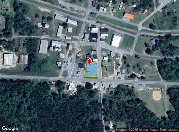
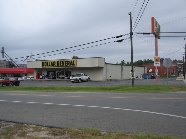
Property Record
1886 W Highway 280, Milan, GA 31060

NEARBY LISTINGS FOR SALE OR LEASE
Property Detail
1886 W Highway 280
MI1A00-041
Milan 102
Wholesaleoutletdiscountstore
COMM 17Q 315-18 (ML1-6-3)
X
Telfair
13271C0050C
Georgia
2024
75
2024
0.52 AC
950200
Georgia South Area
8,000 SF
Other Market Areas
DEMOGRAPHICS near 1886 W Highway 280
1 Mile
3 Mile
5 Mile
2024 Total Population
654
1,040
1,663
2029 Population
662
1,052
1,689
Pop Growth 2024-2029
+ 1.22%
+ 1.15%
+ 1.56%
Average Age
41
41
42
2024 Total Households
272
433
690
HH Growth 2024-2029
+ 2.21%
+ 2.08%
+ 2.17%
Median Household Inc
$54,117
$53,889
$53,690
Avg Household Size
2.40
2.40
2.40
2024 Avg HH Vehicles
2.00
2.00
2.00
Median Home Value
$93,055
$93,823
$99,614
Median Year Built
1986
1986
1987
Nearby Places
Map Layers
Map Styles
 Street
 Aerial
- Restaurants
- Banks
- Shops
- Fitness
- Groceries
SALE & LEASE HISTORY
LISTING DATE
SALE/LEASE

Sep 07, 2017
For Sale
Nearby Properties
Address
Land Use
TOTAL SIZE
Lot Size
Zoning
Address
Land Use
TOTAL SIZE
Lot Size
Zoning
304.10 AC
001
Address
Land Use
TOTAL SIZE
Lot Size
Zoning
27,480 SF
6.36 AC
Address
Land Use
TOTAL SIZE
Lot Size
Zoning
1,024 SF
346.60 AC
RESIDENTIA
Address
Land Use
TOTAL SIZE
Lot Size
Zoning
217.76 AC
001
Address
Land Use
TOTAL SIZE
Lot Size
Zoning
342.08 AC
UNZONED RU
Address
Land Use
TOTAL SIZE
Lot Size
Zoning
202.01 AC
001
Address
Land Use
TOTAL SIZE
Lot Size
Zoning
1,194 SF
147.98 AC
RESIDENTIA
Address
Land Use
TOTAL SIZE
Lot Size
Zoning
1,821 SF
13.94 AC
001
Address
Land Use
TOTAL SIZE
Lot Size
Zoning
170.62 AC
RESIDENTIA
Address
Land Use
TOTAL SIZE
Lot Size
Zoning
101 AC
UNZONED RU
Address
Land Use
TOTAL SIZE
Lot Size
Zoning
32,310 SF
3.77 AC
RESIDENTIA
Address
Land Use
TOTAL SIZE
Lot Size
Zoning
1,260 SF
119 AC
UNZONED RU
Address
Land Use
TOTAL SIZE
Lot Size
Zoning
99.76 AC
RESIDENTIA
Address
Land Use
TOTAL SIZE
Lot Size
Zoning
4,000 SF
0.15 AC
RESIDENTIA
Address
Land Use
TOTAL SIZE
Lot Size
Zoning
130 AC
RESIDENTIA
Address
Land Use
TOTAL SIZE
Lot Size
Zoning
980 SF
100.99 AC
001
Address
Land Use
TOTAL SIZE
Lot Size
Zoning
100 AC
RESIDENTIA
Address
Land Use
TOTAL SIZE
Lot Size
Zoning
35,000 SF
1.84 AC
001
Address
Land Use
TOTAL SIZE
Lot Size
Zoning
100 AC
001
Address
Land Use
TOTAL SIZE
Lot Size
Zoning
960 SF
148 AC
RESIDENTIA
Address
Land Use
TOTAL SIZE
Lot Size
Zoning
12,894 SF
1.44 AC
COMMERCIAL
Address
Land Use
TOTAL SIZE
Lot Size
Zoning
727 SF
3.64 AC
RESIDENTIA
Address
Land Use
TOTAL SIZE
Lot Size
Zoning
7,680 SF
3.27 AC
RESIDENTIA
Address
Land Use
TOTAL SIZE
Lot Size
Zoning
76.75 AC
RESIDENTIA
Address
Land Use
TOTAL SIZE
Lot Size
Zoning
2,760 SF
2.03 AC
COMMERCIAL
Address
Land Use
TOTAL SIZE
Lot Size
Zoning
69.09 AC
RESIDENTIA
Address
Land Use
TOTAL SIZE
Lot Size
Zoning
11,200 SF
0.37 AC
RESIDENTIA
Address
Land Use
TOTAL SIZE
Lot Size
Zoning
1,452 SF
56.55 AC
001
Address
Land Use
TOTAL SIZE
Lot Size
Zoning
0.49 AC
RESIDENTIA
The World's #1 Commercial Real Estate Marketplace
Connect with us
© 2026 CoStar Group
The information above has been obtained from sources believed reliable. While we do not doubt its accuracy we have not verified it and make no guarantee, warranty or representation about it. It is your responsibility to independently confirm its accuracy and completeness. Any projections, opinions, assumptions, or estimates used are for example only and do not represent the current or future performance of the property. The value of this transaction to you depends on tax and other factors which should be evaluated by your tax, financial, and legal advisors. You and your advisors should conduct a careful, independent investigation of the property to determine to your satisfaction the suitability of the property for your needs.