Property Record
1888 Somerton Pl, Virginia Beach, VA 23464


NEARBY LISTINGS FOR SALE OR LEASE
-
-
View all Virginia Beach listings for sale on LoopNet.com
Property Detail
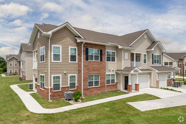
1888 Somerton Pl
Virginia Beach-Chesapeake-Norfolk, VA-NC
Avondale At Kempsville
1455-82-1563
OF PARCEL A-1 PARCEL A-1-A 13.493 ACS 13.115 AC
Apartment
Virginia Beach
A
Virginia
5100340018D
a-1-a
2024
13.12 AC
2025
Outer Virginia Beach County
046207
Hampton Roads
2 SF
DEMOGRAPHICS near 1888 Somerton Pl
1 Mile
3 Mile
5 Mile
2024 Total Population
13,303
96,614
249,185
2029 Population
13,265
96,925
250,808
Pop Growth 2024-2029
(0.29%)
+ 0.32%
+ 0.65%
Average Age
38
39
39
2024 Total Households
4,802
36,965
95,594
HH Growth 2024-2029
(0.42%)
+ 0.35%
+ 0.68%
Median Household Inc
$88,401
$86,743
$80,447
Avg Household Size
2.70
2.60
2.50
2024 Avg HH Vehicles
2.00
2.00
2.00
Median Home Value
$274,771
$286,396
$278,200
Median Year Built
1987
1984
1984
Nearby Places
Map Layers
Map Styles
 Street
 Aerial
- Restaurants
- Banks
- Shops
- Fitness
- Groceries
PUBLIC TRANSPORTATION
COMMUTER RAIL
Norfolk (Northeast Regional - Amtrak)
DRIVE
WALK
Distance
Norfolk (Northeast Regional - Amtrak)
16 min
8.2 mi
AIRPORT
Norfolk International
DRIVE
WALK
Distance
Norfolk International
18 min
10.2 mi
Newport News/Williamsburg International
DRIVE
WALK
Distance
Newport News/Williamsburg International
53 min
35.7 mi
Freight Ports
Virginia Port Authority - Portsmouth
DRIVE
WALK
Distance
Virginia Port Authority - Portsmouth
26 min
13.2 mi
Nearby Properties
Address
Land Use
TOTAL SIZE
Lot Size
Zoning
Address
Land Use
TOTAL SIZE
Lot Size
Zoning
405,992 SF
40.22 AC
PUD: PLANN
Address
Land Use
TOTAL SIZE
Lot Size
Zoning
439,870 SF
24.90 AC
PUD: PLANN
Address
Land Use
TOTAL SIZE
Lot Size
Zoning
1 SF
20.80 AC
A18
Address
Land Use
TOTAL SIZE
Lot Size
Zoning
17.04 AC
A24
Address
Land Use
TOTAL SIZE
Lot Size
Zoning
209,403 SF
2.81 AC
PUD: PLANN
Address
Land Use
TOTAL SIZE
Lot Size
Zoning
95,354 SF
39.53 AC
B2: GENERA
Address
Land Use
TOTAL SIZE
Lot Size
Zoning
264,213 SF
17.59 AC
PUD: PLANN
Address
Land Use
TOTAL SIZE
Lot Size
Zoning
10.36 AC
A24
Address
Land Use
TOTAL SIZE
Lot Size
Zoning
145,522 SF
15.51 AC
PUD: PLANN
Address
Land Use
TOTAL SIZE
Lot Size
Zoning
71,711 SF
11.65 AC
B4
Address
Land Use
TOTAL SIZE
Lot Size
Zoning
3 SF
19.50 AC
A12
Address
Land Use
TOTAL SIZE
Lot Size
Zoning
168,391 SF
28.39 AC
B2: GENERA
Address
Land Use
TOTAL SIZE
Lot Size
Zoning
218,812 SF
45.15 AC
PUD: PLANN
Address
Land Use
TOTAL SIZE
Lot Size
Zoning
26.63 AC
Address
Land Use
TOTAL SIZE
Lot Size
Zoning
270,962 SF
6.17 AC
MXD-U: MIX
Address
Land Use
TOTAL SIZE
Lot Size
Zoning
262,920 SF
20.94 AC
PUD: PLANN
Address
Land Use
TOTAL SIZE
Lot Size
Zoning
303,401 SF
12.98 AC
A24
Address
Land Use
TOTAL SIZE
Lot Size
Zoning
1 SF
16.15 AC
PDH1
Address
Land Use
TOTAL SIZE
Lot Size
Zoning
401,302 SF
18.74 AC
M2: GENERA
Address
Land Use
TOTAL SIZE
Lot Size
Zoning
287,268 SF
83.63 AC
MULTI: MUL
Address
Land Use
TOTAL SIZE
Lot Size
Zoning
240,547 SF
6.18 AC
PUD: PLANN
Address
Land Use
TOTAL SIZE
Lot Size
Zoning
16.03 AC
A24
Address
Land Use
TOTAL SIZE
Lot Size
Zoning
132,309 SF
18.59 AC
O2
Address
Land Use
TOTAL SIZE
Lot Size
Zoning
294,457 SF
47.04 AC
R75
Address
Land Use
TOTAL SIZE
Lot Size
Zoning
330,353 SF
17.61 AC
O2
Address
Land Use
TOTAL SIZE
Lot Size
Zoning
162,291 SF
2.98 AC
PUD: PLANN
Address
Land Use
TOTAL SIZE
Lot Size
Zoning
1 SF
10.64 AC
PDH1
Address
Land Use
TOTAL SIZE
Lot Size
Zoning
193,950 SF
10.68 AC
A24
Address
Land Use
TOTAL SIZE
Lot Size
Zoning
1,880 SF
13.30 AC
PUD: PLANN
The World's #1 Commercial Real Estate Marketplace
Connect with us
© 2026 CoStar Group
The information above has been obtained from sources believed reliable. While we do not doubt its accuracy we have not verified it and make no guarantee, warranty or representation about it. It is your responsibility to independently confirm its accuracy and completeness. Any projections, opinions, assumptions, or estimates used are for example only and do not represent the current or future performance of the property. The value of this transaction to you depends on tax and other factors which should be evaluated by your tax, financial, and legal advisors. You and your advisors should conduct a careful, independent investigation of the property to determine to your satisfaction the suitability of the property for your needs.