Property Record
1889 Route 38, Southampton, NJ 08088

Save to a Folder
{{folder.Name}}
{{folder.ListingIds.length}} Properties
{{folder.ListingIds.length}} Property
Create a New Folder
Property Detail
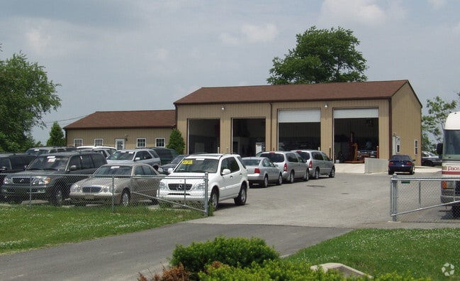
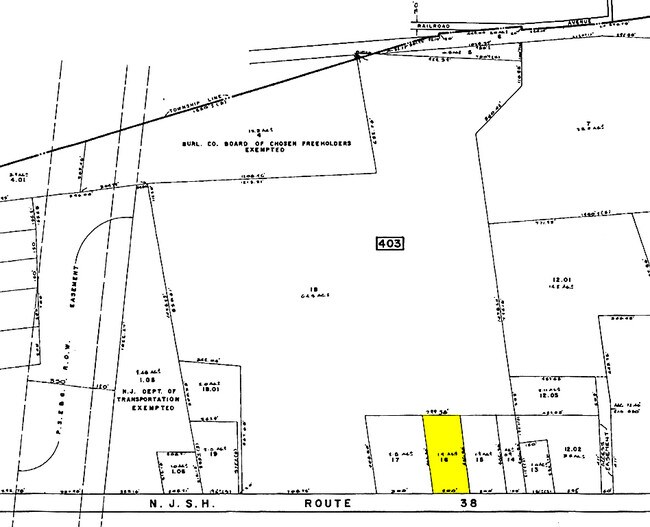
1889 Route 38
33-00403-0000-00016
Burlington
Vehiclerentalsvehiclesales
New Jersey
HC
16
B and X Area of moderate flood hazard, usually the area between the limits of the 100-year and 500-year floods.
2.02 AC
2025
South Burlington County
2026
Philadelphia
703202
Philadelphia-Camden-Wilmington, PA-NJ-DE-MD
1,152 SF
NEARBY LISTINGS FOR SALE OR LEASE
DEMOGRAPHICS near 1889 Route 38
1 mile
3 mile
5 mile
2025 Total Population
1,489
25,135
53,661
2030 Population
1,575
26,213
55,604
Pop Growth 2025-2030
+ 5.78%
+ 4.29%
+ 3.62%
Average Age
45
40
41
2025 Total Households
644
9,735
20,552
HH Growth 2025-2030
+ 5.90%
+ 4.60%
+ 3.91%
Median Household Inc
$95,460
$94,756
$98,743
Avg Household Size
2.30
2.50
2.50
2025 Avg HH Vehicles
2.00
2.00
2.00
Median Home Value
$272,429
$339,133
$351,042
Median Year Built
1974
1979
1978
Nearby Places
Map Layers
Map Styles
 Street
 Aerial
Layers
 Traffic
 Biking
Places
Listings with unknown addresses are not visible on the map
- Restaurants
- Banks
- Shops
- Fitness
- Groceries
PUBLIC TRANSPORTATION
AIRPORT
Trenton Mercer
Drive
Walk
Distance
Trenton Mercer
40 min
26.2 mi
Philadelphia International
Drive
Walk
Distance
Philadelphia International
51 min
34.9 mi
Freight Ports
South Jersey Port
Drive
Walk
Distance
South Jersey Port
34 min
21.8 mi
Nearby Properties
Address
Land Use
TOTAL SIZE
Lot Size
Zoning
Address
Land Use
TOTAL SIZE
Lot Size
Zoning
3.10 AC
HL
Address
Land Use
TOTAL SIZE
Lot Size
Zoning
Address
Land Use
TOTAL SIZE
Lot Size
Zoning
40.50 AC
I2
Address
Land Use
TOTAL SIZE
Lot Size
Zoning
27.64 AC
Address
Land Use
TOTAL SIZE
Lot Size
Zoning
69.60 AC
I2
Address
Land Use
TOTAL SIZE
Lot Size
Zoning
12.31 AC
Address
Land Use
TOTAL SIZE
Lot Size
Zoning
5.29 AC
TC
Address
Land Use
TOTAL SIZE
Lot Size
Zoning
16.79 AC
R12
Address
Land Use
TOTAL SIZE
Lot Size
Zoning
Address
Land Use
TOTAL SIZE
Lot Size
Zoning
15.60 AC
RH
Address
Land Use
TOTAL SIZE
Lot Size
Zoning
121,500 SF
4.11 AC
Address
Land Use
TOTAL SIZE
Lot Size
Zoning
15 AC
R2
Address
Land Use
TOTAL SIZE
Lot Size
Zoning
23.33 AC
B2
Address
Land Use
TOTAL SIZE
Lot Size
Zoning
24.36 AC
Address
Land Use
TOTAL SIZE
Lot Size
Zoning
88.50 AC
MR
Address
Land Use
TOTAL SIZE
Lot Size
Zoning
20 AC
R12
Address
Land Use
TOTAL SIZE
Lot Size
Zoning
35 AC
R2.5
Address
Land Use
TOTAL SIZE
Lot Size
Zoning
11.53 AC
RH
Address
Land Use
TOTAL SIZE
Lot Size
Zoning
1.34 AC
GS
Address
Land Use
TOTAL SIZE
Lot Size
Zoning
13.50 AC
R1
Address
Land Use
TOTAL SIZE
Lot Size
Zoning
16.52 AC
Address
Land Use
TOTAL SIZE
Lot Size
Zoning
10,000 SF
11.02 AC
B2
Address
Land Use
TOTAL SIZE
Lot Size
Zoning
16,436 SF
7.27 AC
R12
Address
Land Use
TOTAL SIZE
Lot Size
Zoning
1.07 AC
B1
Address
Land Use
TOTAL SIZE
Lot Size
Zoning
0.56 AC
GS
Address
Land Use
TOTAL SIZE
Lot Size
Zoning
10.80 AC
BP
Address
Land Use
TOTAL SIZE
Lot Size
Zoning
25 AC
R1B
Address
Land Use
TOTAL SIZE
Lot Size
Zoning
10.58 AC
R2
Address
Land Use
TOTAL SIZE
Lot Size
Zoning
22,670 SF
23.37 AC
I
Address
Land Use
TOTAL SIZE
Lot Size
Zoning
65 AC
I
The World's #1 Commercial Real Estate Marketplace
Connect with us
© 2026 CoStar Group
The information above has been obtained from sources believed reliable. While we do not doubt its accuracy we have not verified it and make no guarantee, warranty or representation about it. It is your responsibility to independently confirm its accuracy and completeness. Any projections, opinions, assumptions, or estimates used are for example only and do not represent the current or future performance of the property. The value of this transaction to you depends on tax and other factors which should be evaluated by your tax, financial, and legal advisors. You and your advisors should conduct a careful, independent investigation of the property to determine to your satisfaction the suitability of the property for your needs.