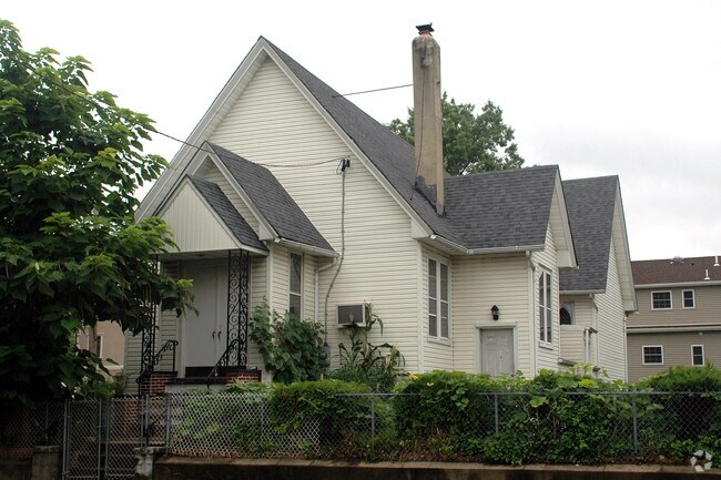
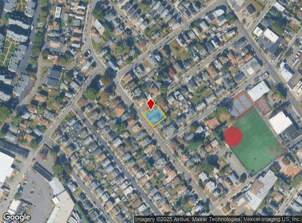
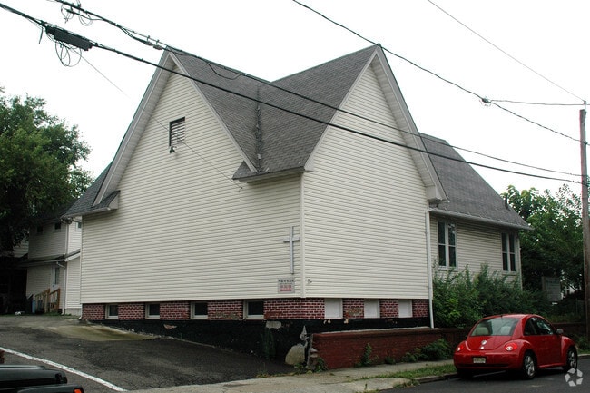
Property Record
189 Carlton Ave, East Rutherford, NJ 07073

NEARBY LISTINGS FOR SALE OR LEASE
Property Detail
189 Carlton Ave
12-00013-0000-00014
CHURCH
Religious
Bergen
AE
New Jersey
34031C0276G
14
0
0.23 AC
2025
Meadowlands
012002
Northern New Jersey
1,712 SF
New York-Jersey City-White Plains, NY-NJ
DEMOGRAPHICS near 189 Carlton Ave
1 Mile
3 Mile
5 Mile
2024 Total Population
38,712
264,831
580,611
2029 Population
37,736
257,317
565,088
Pop Growth 2024-2029
(2.52%)
(2.84%)
(2.67%)
Average Age
38
39
40
2024 Total Households
13,816
93,204
208,904
HH Growth 2024-2029
(2.57%)
(2.92%)
(2.74%)
Median Household Inc
$65,981
$75,841
$81,445
Avg Household Size
2.70
2.80
2.70
2024 Avg HH Vehicles
1.00
2.00
2.00
Median Home Value
$453,103
$442,966
$428,053
Median Year Built
1952
1951
1954
Nearby Places
Map Layers
Map Styles
 Street
 Aerial
- Restaurants
- Banks
- Shops
- Fitness
- Groceries
PUBLIC TRANSPORTATION
COMMUTER RAIL
Passaic (Main/Port Jervis Line - NJ Transit Commuter Rail (NJ Transit))
DRIVE
WALK
Distance
Passaic (Main/Port Jervis Line - NJ Transit Commuter Rail (NJ Transit))
4 min
2.2 mi
Wesmont (Main/Bergen County Line - NJ TRANSIT RAIL, Port Jervis Line - NJ TRANSIT RAIL)
DRIVE
WALK
Distance
Wesmont (Main/Bergen County Line - NJ TRANSIT RAIL, Port Jervis Line - NJ TRANSIT RAIL)
6 min
2.3 mi
AIRPORT
Newark Liberty International
DRIVE
WALK
Distance
Newark Liberty International
17 min
14.4 mi
LaGuardia
DRIVE
WALK
Distance
LaGuardia
36 min
23.1 mi
John F Kennedy International
DRIVE
WALK
Distance
John F Kennedy International
46 min
28.9 mi
Freight Ports
Port Newark Container Terminal
DRIVE
WALK
Distance
Port Newark Container Terminal
24 min
14.6 mi
SALE & LEASE HISTORY
LISTING DATE
SALE/LEASE

Sep 23, 2016
For Sale
Mar 03, 2017
For Sale
Nearby Properties
Address
Land Use
TOTAL SIZE
Lot Size
Zoning
Address
Land Use
TOTAL SIZE
Lot Size
Zoning
Address
Land Use
TOTAL SIZE
Lot Size
Zoning
4,014 SF
21 AC
Address
Land Use
TOTAL SIZE
Lot Size
Zoning
612 AC
SEA
Address
Land Use
TOTAL SIZE
Lot Size
Zoning
335.71 AC
AF
Address
Land Use
TOTAL SIZE
Lot Size
Zoning
Address
Land Use
TOTAL SIZE
Lot Size
Zoning
9.57 AC
I2
Address
Land Use
TOTAL SIZE
Lot Size
Zoning
7.10 AC
R-3
Address
Land Use
TOTAL SIZE
Lot Size
Zoning
Address
Land Use
TOTAL SIZE
Lot Size
Zoning
30.46 AC
I
Address
Land Use
TOTAL SIZE
Lot Size
Zoning
8.88 AC
ORD
Address
Land Use
TOTAL SIZE
Lot Size
Zoning
1,218 SF
41.30 AC
RB
Address
Land Use
TOTAL SIZE
Lot Size
Zoning
1.12 AC
M-O
Address
Land Use
TOTAL SIZE
Lot Size
Zoning
4.80 AC
Address
Land Use
TOTAL SIZE
Lot Size
Zoning
Address
Land Use
TOTAL SIZE
Lot Size
Zoning
18.30 AC
Address
Land Use
TOTAL SIZE
Lot Size
Zoning
144,024 SF
1 AC
LM
Address
Land Use
TOTAL SIZE
Lot Size
Zoning
24.29 AC
Address
Land Use
TOTAL SIZE
Lot Size
Zoning
82.74 AC
Address
Land Use
TOTAL SIZE
Lot Size
Zoning
71,634 SF
12.31 AC
M1
Address
Land Use
TOTAL SIZE
Lot Size
Zoning
16.94 AC
R2
Address
Land Use
TOTAL SIZE
Lot Size
Zoning
24.35 AC
Address
Land Use
TOTAL SIZE
Lot Size
Zoning
860 SF
0.96 AC
R100
Address
Land Use
TOTAL SIZE
Lot Size
Zoning
267,069 SF
6.15 AC
Address
Land Use
TOTAL SIZE
Lot Size
Zoning
Address
Land Use
TOTAL SIZE
Lot Size
Zoning
13.80 AC
Address
Land Use
TOTAL SIZE
Lot Size
Zoning
11.30 AC
Address
Land Use
TOTAL SIZE
Lot Size
Zoning
150,018 SF
4.17 AC
B
Address
Land Use
TOTAL SIZE
Lot Size
Zoning
Address
Land Use
TOTAL SIZE
Lot Size
Zoning
13.36 AC
Address
Land Use
TOTAL SIZE
Lot Size
Zoning
0.22 AC
The World's #1 Commercial Real Estate Marketplace
Connect with us
© 2025 CoStar Group
The information above has been obtained from sources believed reliable. While we do not doubt its accuracy we have not verified it and make no guarantee, warranty or representation about it. It is your responsibility to independently confirm its accuracy and completeness. Any projections, opinions, assumptions, or estimates used are for example only and do not represent the current or future performance of the property. The value of this transaction to you depends on tax and other factors which should be evaluated by your tax, financial, and legal advisors. You and your advisors should conduct a careful, independent investigation of the property to determine to your satisfaction the suitability of the property for your needs.