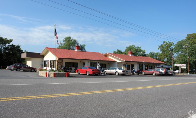
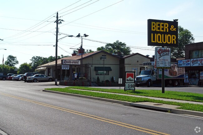
Property Record
189 E Main St, Hancock, MD 21750

Property Detail
189 E Main St
05-001676
LOT 99X105 .24 AC E MAIN ST HANCOCK
Commercialnec
Washington
U
Maryland
B and X Area of moderate flood hazard, usually the area between the limits of the 100-year and 500-year floods.
0.45 AC
2024
Washington County
2025
Washington, DC
010700
Hagerstown-Martinsburg, MD-WV
5,903 SF
NEARBY LISTINGS FOR SALE OR LEASE
-
-
View all Hancock listings for sale on LoopNet.com
DEMOGRAPHICS near 189 E Main St
1 mile
3 mile
5 mile
2024 Total Population
1,182
3,372
6,504
2029 Population
1,220
3,439
6,609
Pop Growth 2024-2029
+ 3.21%
+ 1.99%
+ 1.61%
Average Age
43
44
44
2024 Total Households
531
1,473
2,748
HH Growth 2024-2029
+ 3.20%
+ 2.04%
+ 1.71%
Median Household Inc
$50,422
$55,407
$62,918
Avg Household Size
2.20
2.30
2.30
2024 Avg HH Vehicles
2.00
2.00
2.00
Median Home Value
$211,667
$226,370
$231,471
Median Year Built
1958
1972
1978
Nearby Places
Map Layers
Map Styles
 Street
 Aerial
Transit
 Traffic
 Biking
Places
Listings with unknown addresses are not visible on the map
- Restaurants
- Banks
- Shops
- Fitness
- Groceries
PUBLIC TRANSPORTATION
AIRPORT
Hagerstown Regional/Richard A Henson Field
Drive
Walk
Distance
Hagerstown Regional/Richard A Henson Field
40 min
31.2 mi
SALE & LEASE HISTORY
LISTING DATE
SALE/LEASE

Sep 23, 2016
For Sale
Mar 07, 2017
For Sale
Apr 05, 2022
For Sale
Nearby Properties
Address
Land Use
TOTAL SIZE
Lot Size
Zoning
Address
Land Use
TOTAL SIZE
Lot Size
Zoning
96,809 SF
44.73 AC
U
Address
Land Use
TOTAL SIZE
Lot Size
Zoning
37,441 SF
16.97 AC
U
Address
Land Use
TOTAL SIZE
Lot Size
Zoning
25,721 SF
18.23 AC
U
Address
Land Use
TOTAL SIZE
Lot Size
Zoning
28,800 SF
52.35 AC
U
Address
Land Use
TOTAL SIZE
Lot Size
Zoning
36,808 SF
31.56 AC
U
Address
Land Use
TOTAL SIZE
Lot Size
Zoning
62,260 SF
54.48 AC
HI
Address
Land Use
TOTAL SIZE
Lot Size
Zoning
89,750 SF
14.04 AC
U
Address
Land Use
TOTAL SIZE
Lot Size
Zoning
3,270 SF
18.82 AC
BG
Address
Land Use
TOTAL SIZE
Lot Size
Zoning
58,599 SF
5.25 AC
BG
Address
Land Use
TOTAL SIZE
Lot Size
Zoning
21,488 SF
0.32 AC
U
Address
Land Use
TOTAL SIZE
Lot Size
Zoning
26,600 SF
1.55 AC
U
Address
Land Use
TOTAL SIZE
Lot Size
Zoning
8,134 SF
18 AC
Address
Land Use
TOTAL SIZE
Lot Size
Zoning
26,214 SF
1.89 AC
U
Address
Land Use
TOTAL SIZE
Lot Size
Zoning
6,060 SF
8.96 AC
U
Address
Land Use
TOTAL SIZE
Lot Size
Zoning
22,590 SF
1.12 AC
U
Address
Land Use
TOTAL SIZE
Lot Size
Zoning
800 SF
146.66 AC
EC
Address
Land Use
TOTAL SIZE
Lot Size
Zoning
18,000 SF
6.41 AC
U
Address
Land Use
TOTAL SIZE
Lot Size
Zoning
5,794 SF
3.24 AC
EC
Address
Land Use
TOTAL SIZE
Lot Size
Zoning
113.07 AC
Address
Land Use
TOTAL SIZE
Lot Size
Zoning
8,640 SF
0.32 AC
U
Address
Land Use
TOTAL SIZE
Lot Size
Zoning
2,088 SF
3.50 AC
U
Address
Land Use
TOTAL SIZE
Lot Size
Zoning
7,360 SF
7.35 AC
U
Address
Land Use
TOTAL SIZE
Lot Size
Zoning
15,092 SF
2.02 AC
U
Address
Land Use
TOTAL SIZE
Lot Size
Zoning
5,296 SF
0.22 AC
U
Address
Land Use
TOTAL SIZE
Lot Size
Zoning
2,232 SF
0.41 AC
U
Address
Land Use
TOTAL SIZE
Lot Size
Zoning
2,700 SF
2.80 AC
U
Address
Land Use
TOTAL SIZE
Lot Size
Zoning
12,957 SF
0.50 AC
U
Address
Land Use
TOTAL SIZE
Lot Size
Zoning
2,292 SF
1.69 AC
U
Address
Land Use
TOTAL SIZE
Lot Size
Zoning
183.85 AC
U
Address
Land Use
TOTAL SIZE
Lot Size
Zoning
4,200 SF
0.92 AC
U
The World's #1 Commercial Real Estate Marketplace
Connect with us
© 2026 CoStar Group
The information above has been obtained from sources believed reliable. While we do not doubt its accuracy we have not verified it and make no guarantee, warranty or representation about it. It is your responsibility to independently confirm its accuracy and completeness. Any projections, opinions, assumptions, or estimates used are for example only and do not represent the current or future performance of the property. The value of this transaction to you depends on tax and other factors which should be evaluated by your tax, financial, and legal advisors. You and your advisors should conduct a careful, independent investigation of the property to determine to your satisfaction the suitability of the property for your needs.