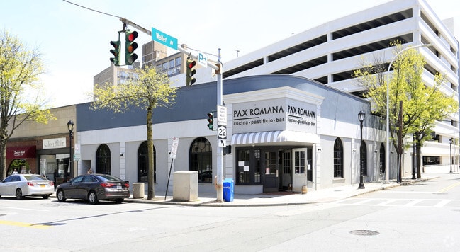
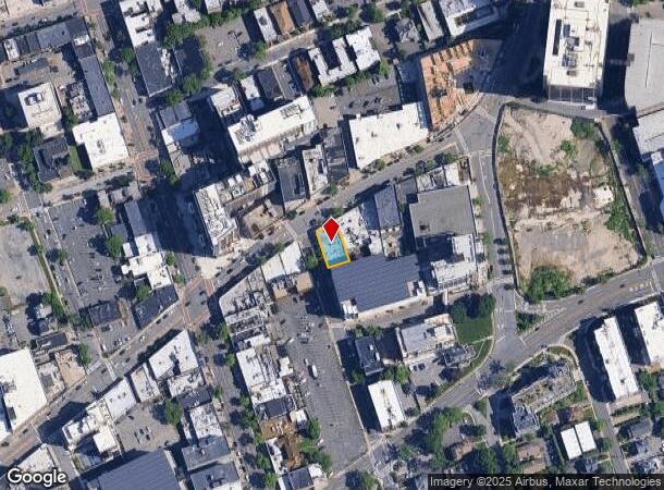
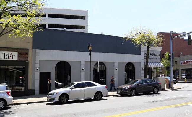
Property Record
189 E Post Rd, White Plains, NY 10601

NEARBY LISTINGS FOR SALE OR LEASE
Property Detail
189 E Post Rd
1700-125-084-00004-000-0001
Map Property James T Waller
Restaurantbuilding
Westchester
X
New York
36119C0269F
1.000
2025
0.15 AC
2024
White Plains CBD
009400
Westchester/So Connecticut
6,604 SF
New York-Jersey City-White Plains, NY-NJ
DEMOGRAPHICS near 189 E Post Rd
1 Mile
3 Mile
5 Mile
2024 Total Population
43,526
111,599
213,712
2029 Population
43,347
110,167
210,170
Pop Growth 2024-2029
(0.41%)
(1.28%)
(1.66%)
Average Age
42
43
42
2024 Total Households
19,173
43,233
78,022
HH Growth 2024-2029
(0.34%)
(1.26%)
(1.69%)
Median Household Inc
$97,066
$126,019
$145,500
Avg Household Size
2.20
2.40
2.60
2024 Avg HH Vehicles
1.00
2.00
2.00
Median Home Value
$469,230
$653,022
$743,750
Median Year Built
1965
1961
1959
Nearby Places
Map Layers
Map Styles
 Street
 Aerial
- Restaurants
- Banks
- Shops
- Fitness
- Groceries
PUBLIC TRANSPORTATION
COMMUTER RAIL
White Plains Station (Harlem Line - Metro-North Commuter Railroad Company (Metro-North))
DRIVE
WALK
Distance
White Plains Station (Harlem Line - Metro-North Commuter Railroad Company (Metro-North))
2 min
17 min
0.9 mi
North White Plains Station (Harlem Line - Metro-North Commuter Railroad Company (Metro-North))
DRIVE
WALK
Distance
North White Plains Station (Harlem Line - Metro-North Commuter Railroad Company (Metro-North))
3 min
1.8 mi
AIRPORT
Westchester County
DRIVE
WALK
Distance
Westchester County
11 min
7.5 mi
LaGuardia
DRIVE
WALK
Distance
LaGuardia
40 min
23.2 mi
John F Kennedy International
DRIVE
WALK
Distance
John F Kennedy International
46 min
30.8 mi
Freight Ports
NY - Red Hook Container Terminal
DRIVE
WALK
Distance
NY - Red Hook Container Terminal
55 min
33.7 mi
SALE & LEASE HISTORY
LISTING DATE
SALE/LEASE

Sep 24, 2016
For Sale
Mar 10, 2017
For Sale
Nearby Properties
Address
Land Use
TOTAL SIZE
Lot Size
Zoning
Address
Land Use
TOTAL SIZE
Lot Size
Zoning
Address
Land Use
TOTAL SIZE
Lot Size
Zoning
4.45 AC
B
Address
Land Use
TOTAL SIZE
Lot Size
Zoning
381,836 SF
16.68 AC
A3
Address
Land Use
TOTAL SIZE
Lot Size
Zoning
75.87 AC
R-20
Address
Land Use
TOTAL SIZE
Lot Size
Zoning
237,313 SF
22.67 AC
A1
Address
Land Use
TOTAL SIZE
Lot Size
Zoning
16.22 AC
UR
Address
Land Use
TOTAL SIZE
Lot Size
Zoning
22.44 AC
R-20
Address
Land Use
TOTAL SIZE
Lot Size
Zoning
7.98 AC
CA
Address
Land Use
TOTAL SIZE
Lot Size
Zoning
1,975 SF
13.80 AC
CA
Address
Land Use
TOTAL SIZE
Lot Size
Zoning
29.42 AC
PUD
Address
Land Use
TOTAL SIZE
Lot Size
Zoning
10.90 AC
UR
Address
Land Use
TOTAL SIZE
Lot Size
Zoning
3.16 AC
Address
Land Use
TOTAL SIZE
Lot Size
Zoning
5.57 AC
AA1
Address
Land Use
TOTAL SIZE
Lot Size
Zoning
64.41 AC
R-20
Address
Land Use
TOTAL SIZE
Lot Size
Zoning
1,200 SF
21.21 AC
R-20
Address
Land Use
TOTAL SIZE
Lot Size
Zoning
7.98 AC
M-14
Address
Land Use
TOTAL SIZE
Lot Size
Zoning
0.58 AC
B
Address
Land Use
TOTAL SIZE
Lot Size
Zoning
48,267 SF
11.04 AC
A2 A
Address
Land Use
TOTAL SIZE
Lot Size
Zoning
11.21 AC
R-20
Address
Land Use
TOTAL SIZE
Lot Size
Zoning
84,450 SF
3.19 AC
B
Address
Land Use
TOTAL SIZE
Lot Size
Zoning
5.43 AC
R-40
Address
Land Use
TOTAL SIZE
Lot Size
Zoning
320 SF
5.38 AC
LI
Address
Land Use
TOTAL SIZE
Lot Size
Zoning
1,348 SF
5.67 AC
CA
Address
Land Use
TOTAL SIZE
Lot Size
Zoning
6.09 AC
DS
Address
Land Use
TOTAL SIZE
Lot Size
Zoning
1,630 SF
2.64 AC
LOB
Address
Land Use
TOTAL SIZE
Lot Size
Zoning
2,100 SF
24.12 AC
A3
Address
Land Use
TOTAL SIZE
Lot Size
Zoning
121.29 AC
Address
Land Use
TOTAL SIZE
Lot Size
Zoning
68,616 SF
3.11 AC
Address
Land Use
TOTAL SIZE
Lot Size
Zoning
2.26 AC
CA
Address
Land Use
TOTAL SIZE
Lot Size
Zoning
8.05 AC
R-10
The World's #1 Commercial Real Estate Marketplace
Connect with us
© 2025 CoStar Group
The information above has been obtained from sources believed reliable. While we do not doubt its accuracy we have not verified it and make no guarantee, warranty or representation about it. It is your responsibility to independently confirm its accuracy and completeness. Any projections, opinions, assumptions, or estimates used are for example only and do not represent the current or future performance of the property. The value of this transaction to you depends on tax and other factors which should be evaluated by your tax, financial, and legal advisors. You and your advisors should conduct a careful, independent investigation of the property to determine to your satisfaction the suitability of the property for your needs.