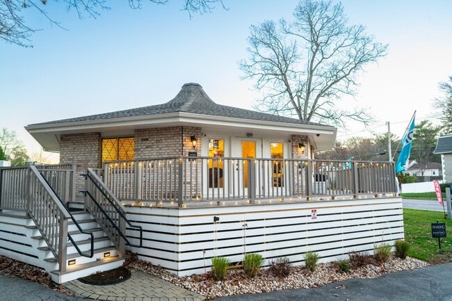
Property Record
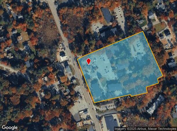
189 Main St, North Reading, MA 01864
NEARBY LISTINGS FOR SALE OR LEASE
Property Detail
189 Main St
Officecondo
Middlesex
X
Massachusetts
25017C0303F
9109.0
2025
Wilmington/Reading
2025
Boston
330201
Boston-Cambridge-Newton, MA-NH
1,166 SF
NREA-000026-000000-000079-009109
DEMOGRAPHICS near 189 Main St
1 Mile
3 Mile
5 Mile
2024 Total Population
5,310
28,807
99,017
2029 Population
5,411
28,718
98,757
Pop Growth 2024-2029
+ 1.90%
(0.31%)
(0.26%)
Average Age
43
42
42
2024 Total Households
2,204
10,336
35,199
HH Growth 2024-2029
+ 2.04%
(0.27%)
(0.29%)
Median Household Inc
$109,447
$142,379
$145,330
Avg Household Size
2.30
2.70
2.70
2024 Avg HH Vehicles
2.00
2.00
2.00
Median Home Value
$657,575
$722,132
$705,504
Median Year Built
1989
1972
1971
Nearby Places
Map Layers
Map Styles
 Street
 Aerial
- Restaurants
- Banks
- Shops
- Fitness
- Groceries
PUBLIC TRANSPORTATION
COMMUTER RAIL
North Wilmington (Haverhill Line - Massachusetts Bay Transportation Authority Commuter Rail (Purple Line))
DRIVE
WALK
Distance
North Wilmington (Haverhill Line - Massachusetts Bay Transportation Authority Commuter Rail (Purple Line))
6 min
3.0 mi
Ballardvale (Haverhill Line - Massachusetts Bay Transportation Authority Commuter Rail (Purple Line))
DRIVE
WALK
Distance
Ballardvale (Haverhill Line - Massachusetts Bay Transportation Authority Commuter Rail (Purple Line))
10 min
5.1 mi
AIRPORT
General Edward Lawrence Logan International
DRIVE
WALK
Distance
General Edward Lawrence Logan International
31 min
21.5 mi
Manchester Boston Regional
DRIVE
WALK
Distance
Manchester Boston Regional
53 min
36.5 mi
Freight Ports
Port of Boston
DRIVE
WALK
Distance
Port of Boston
32 min
21.3 mi
SALE & LEASE HISTORY
LISTING DATE
SALE/LEASE

Mar 28, 2025
For Sale
Nearby Properties
Address
Land Use
TOTAL SIZE
Lot Size
Zoning
Address
Land Use
TOTAL SIZE
Lot Size
Zoning
502,199 SF
47.78 AC
IO
Address
Land Use
TOTAL SIZE
Lot Size
Zoning
272,632 SF
22.49 AC
IND
Address
Land Use
TOTAL SIZE
Lot Size
Zoning
341,215 SF
16.94 AC
IND
Address
Land Use
TOTAL SIZE
Lot Size
Zoning
304,672 SF
58.97 AC
HB
Address
Land Use
TOTAL SIZE
Lot Size
Zoning
368,748 SF
40.10 AC
IND
Address
Land Use
TOTAL SIZE
Lot Size
Zoning
343,105 SF
60.18 AC
IND
Address
Land Use
TOTAL SIZE
Lot Size
Zoning
78,384 SF
34.20 AC
IO
Address
Land Use
TOTAL SIZE
Lot Size
Zoning
221,927 SF
27.88 AC
IND
Address
Land Use
TOTAL SIZE
Lot Size
Zoning
113,502 SF
8.50 AC
LB
Address
Land Use
TOTAL SIZE
Lot Size
Zoning
193.30 AC
IA
Address
Land Use
TOTAL SIZE
Lot Size
Zoning
175,682 SF
20.80 AC
IB
Address
Land Use
TOTAL SIZE
Lot Size
Zoning
238,042 SF
28 AC
IND
Address
Land Use
TOTAL SIZE
Lot Size
Zoning
127,016 SF
11.01 AC
IB
Address
Land Use
TOTAL SIZE
Lot Size
Zoning
124,741 SF
13.35 AC
HB
Address
Land Use
TOTAL SIZE
Lot Size
Zoning
148,284 SF
8.16 AC
IB
Address
Land Use
TOTAL SIZE
Lot Size
Zoning
119,992 SF
9.60 AC
S20
Address
Land Use
TOTAL SIZE
Lot Size
Zoning
122,112 SF
15.78 AC
S20
Address
Land Use
TOTAL SIZE
Lot Size
Zoning
138,540 SF
13.51 AC
IB
Address
Land Use
TOTAL SIZE
Lot Size
Zoning
151,790 SF
10.50 AC
IB
Address
Land Use
TOTAL SIZE
Lot Size
Zoning
133,877 SF
16.30 AC
IND
Address
Land Use
TOTAL SIZE
Lot Size
Zoning
98,481 SF
63.67 AC
IND
Address
Land Use
TOTAL SIZE
Lot Size
Zoning
143,865 SF
20.23 AC
IND
Address
Land Use
TOTAL SIZE
Lot Size
Zoning
154,395 SF
21.65 AC
HB
Address
Land Use
TOTAL SIZE
Lot Size
Zoning
167,654 SF
14.84 AC
GI
Address
Land Use
TOTAL SIZE
Lot Size
Zoning
123,700 SF
9.43 AC
Address
Land Use
TOTAL SIZE
Lot Size
Zoning
106,035 SF
8.65 AC
IND
Address
Land Use
TOTAL SIZE
Lot Size
Zoning
187,898 SF
14 AC
IND
Address
Land Use
TOTAL SIZE
Lot Size
Zoning
111,758 SF
6.72 AC
IND
Address
Land Use
TOTAL SIZE
Lot Size
Zoning
177,112 SF
13.86 AC
IND
Address
Land Use
TOTAL SIZE
Lot Size
Zoning
100,720 SF
12.64 AC
HI
The World's #1 Commercial Real Estate Marketplace
Connect with us
© 2025 CoStar Group
The information above has been obtained from sources believed reliable. While we do not doubt its accuracy we have not verified it and make no guarantee, warranty or representation about it. It is your responsibility to independently confirm its accuracy and completeness. Any projections, opinions, assumptions, or estimates used are for example only and do not represent the current or future performance of the property. The value of this transaction to you depends on tax and other factors which should be evaluated by your tax, financial, and legal advisors. You and your advisors should conduct a careful, independent investigation of the property to determine to your satisfaction the suitability of the property for your needs.