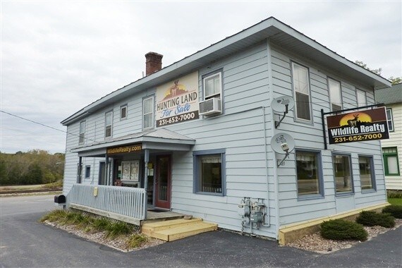
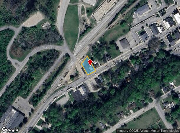
Property Record
189 W State Rd, Newaygo, MI 49337
NEARBY LISTINGS FOR SALE OR LEASE
Property Detail
189 W State Rd
18-24-280-001
City Of Newaygo
Commercialofficeresidentialmixeduse
W'LY 88 FT OF S'LY 1/2 LOT 4 EXC THAT PART LYING N'LY OF LN COM 47.75 FT S'LY FROM NW'LY COR TO PT ON W LN ABV DESC 5.25 F
X
Newaygo
26123C0441D
Michigan
2025
4
2025
0.29 AC
970900
Newaygo County
2,332 SF
West Michigan
DEMOGRAPHICS near 189 W State Rd
1 Mile
3 Mile
5 Mile
2024 Total Population
2,148
6,427
10,725
2029 Population
2,245
6,804
11,359
Pop Growth 2024-2029
+ 4.52%
+ 5.87%
+ 5.91%
Average Age
38
41
42
2024 Total Households
802
2,475
4,106
HH Growth 2024-2029
+ 4.36%
+ 5.86%
+ 5.89%
Median Household Inc
$54,117
$58,999
$60,235
Avg Household Size
2.50
2.50
2.50
2024 Avg HH Vehicles
2.00
2.00
2.00
Median Home Value
$152,619
$179,172
$184,170
Median Year Built
1979
1980
1980
Nearby Places
Map Layers
Map Styles
 Street
 Aerial
- Restaurants
- Banks
- Shops
- Fitness
- Groceries
SALE & LEASE HISTORY
LISTING DATE
SALE/LEASE

Oct 04, 2018
For Sale
Nearby Properties
Address
Land Use
TOTAL SIZE
Lot Size
Zoning
Address
Land Use
TOTAL SIZE
Lot Size
Zoning
Address
Land Use
TOTAL SIZE
Lot Size
Zoning
54,366 SF
7.70 AC
LOCAL ZONE
Address
Land Use
TOTAL SIZE
Lot Size
Zoning
173,880 SF
27 AC
LOCAL ZONE
Address
Land Use
TOTAL SIZE
Lot Size
Zoning
Address
Land Use
TOTAL SIZE
Lot Size
Zoning
8 AC
LOCAL ZONE
Address
Land Use
TOTAL SIZE
Lot Size
Zoning
114,376 SF
21.20 AC
LOCAL ZONE
Address
Land Use
TOTAL SIZE
Lot Size
Zoning
46,733 SF
6.75 AC
LOCAL ZONE
Address
Land Use
TOTAL SIZE
Lot Size
Zoning
57,044 SF
606.89 AC
LOCAL ZONE
Address
Land Use
TOTAL SIZE
Lot Size
Zoning
46,611 SF
10.83 AC
LOCAL ZONE
Address
Land Use
TOTAL SIZE
Lot Size
Zoning
9,452 SF
15.95 AC
LOCAL ZONE
Address
Land Use
TOTAL SIZE
Lot Size
Zoning
35,502 SF
3.12 AC
LOCAL ZONE
Address
Land Use
TOTAL SIZE
Lot Size
Zoning
40,636 SF
10 AC
LOCAL ZONE
Address
Land Use
TOTAL SIZE
Lot Size
Zoning
1,200 SF
39.83 AC
LOCAL ZONE
Address
Land Use
TOTAL SIZE
Lot Size
Zoning
6,178 SF
7.49 AC
LOCAL ZONE
Address
Land Use
TOTAL SIZE
Lot Size
Zoning
25,200 SF
3.30 AC
LOCAL ZONE
Address
Land Use
TOTAL SIZE
Lot Size
Zoning
Address
Land Use
TOTAL SIZE
Lot Size
Zoning
67,240 SF
12.80 AC
LOCAL ZONE
Address
Land Use
TOTAL SIZE
Lot Size
Zoning
85,653 SF
5.17 AC
LOCAL ZONE
Address
Land Use
TOTAL SIZE
Lot Size
Zoning
33 AC
LOCAL ZONE
Address
Land Use
TOTAL SIZE
Lot Size
Zoning
15.43 AC
R1
Address
Land Use
TOTAL SIZE
Lot Size
Zoning
3,374 SF
1.19 AC
LOCAL ZONE
Address
Land Use
TOTAL SIZE
Lot Size
Zoning
2,824 SF
0.48 AC
LOCAL ZONE
Address
Land Use
TOTAL SIZE
Lot Size
Zoning
2,455 SF
1.08 AC
LOCAL ZONE
Address
Land Use
TOTAL SIZE
Lot Size
Zoning
28,608 SF
4.37 AC
LOCAL ZONE
Address
Land Use
TOTAL SIZE
Lot Size
Zoning
0.04 AC
LOCAL ZONE
Address
Land Use
TOTAL SIZE
Lot Size
Zoning
2,092 SF
35 AC
LOCAL ZONE
Address
Land Use
TOTAL SIZE
Lot Size
Zoning
3,304 SF
1.01 AC
LOCAL ZONE
Address
Land Use
TOTAL SIZE
Lot Size
Zoning
Address
Land Use
TOTAL SIZE
Lot Size
Zoning
3,052 SF
1.40 AC
LOCAL ZONE
Address
Land Use
TOTAL SIZE
Lot Size
Zoning
8,827 SF
1.82 AC
LOCAL ZONE
The World's #1 Commercial Real Estate Marketplace
Connect with us
© 2026 CoStar Group
The information above has been obtained from sources believed reliable. While we do not doubt its accuracy we have not verified it and make no guarantee, warranty or representation about it. It is your responsibility to independently confirm its accuracy and completeness. Any projections, opinions, assumptions, or estimates used are for example only and do not represent the current or future performance of the property. The value of this transaction to you depends on tax and other factors which should be evaluated by your tax, financial, and legal advisors. You and your advisors should conduct a careful, independent investigation of the property to determine to your satisfaction the suitability of the property for your needs.