Property Record
1890 Plainfield Pike, Cranston, RI 02921
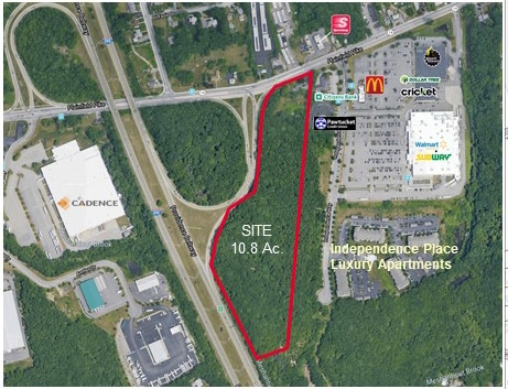
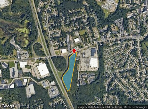


This Property Is For Sale
NEARBY LISTINGS FOR SALE OR LEASE
-
-
-
-
-
Western Industrial Complex, Cranston, RI 02921
Cranston, RI 02921
Rent Upon Request
2.36 - 3.64 AC Lot
Land
-
-
-
View all Cranston listings for sale on LoopNet.com
Property Detail
1890 Plainfield Pike
CRAN-000037-000001-000014
Providence
Sfr
Rhode Island
X
14
44007C0292H
2.42 AC
2025
Cranston
2025
Providence
014800
Providence-Warwick, RI-MA
1,998 SF
DEMOGRAPHICS near 1890 Plainfield Pike
1 mile
3 mile
5 mile
2024 Total Population
6,319
64,303
236,034
2029 Population
6,317
64,009
233,932
Pop Growth 2024-2029
(0.03%)
(0.46%)
(0.89%)
Average Age
45
42
39
2024 Total Households
2,727
25,674
90,744
HH Growth 2024-2029
(0.18%)
(0.48%)
(0.86%)
Median Household Inc
$79,478
$73,298
$65,385
Avg Household Size
2.30
2.40
2.50
2024 Avg HH Vehicles
2.00
2.00
2.00
Median Home Value
$351,612
$326,541
$294,708
Median Year Built
1982
1967
1955
Nearby Places
Map Layers
Map Styles
 Street
 Aerial
Transit
 Traffic
 Biking
Places
Listings with unknown addresses are not visible on the map
- Restaurants
- Banks
- Shops
- Fitness
- Groceries
PUBLIC TRANSPORTATION
COMMUTER RAIL
Providence (Providence/Stoughton Line - Massachusetts Bay Transportation Authority Commuter Rail (Purple Line))
Drive
Walk
Distance
Providence (Providence/Stoughton Line - Massachusetts Bay Transportation Authority Commuter Rail (Purple Line))
11 min
6.2 mi
Tf Green Airport (Providence/Stoughton Line - MBTA)
Drive
Walk
Distance
Tf Green Airport (Providence/Stoughton Line - MBTA)
14 min
8.5 mi
AIRPORT
Rhode Island Tf Green International
Drive
Walk
Distance
Rhode Island Tf Green International
17 min
9.4 mi
Freight Ports
Port of Davisville, RI
Drive
Walk
Distance
Port of Davisville, RI
28 min
18.6 mi
Nearby Properties
Address
Land Use
TOTAL SIZE
Lot Size
Zoning
Address
Land Use
TOTAL SIZE
Lot Size
Zoning
9.06 AC
PS
Address
Land Use
TOTAL SIZE
Lot Size
Zoning
91.15 AC
PUD
Address
Land Use
TOTAL SIZE
Lot Size
Zoning
4,954 SF
11.22 AC
C5
Address
Land Use
TOTAL SIZE
Lot Size
Zoning
333,161 SF
25.85 AC
B1
Address
Land Use
TOTAL SIZE
Lot Size
Zoning
32.30 AC
I
Address
Land Use
TOTAL SIZE
Lot Size
Zoning
27.47 AC
S1
Address
Land Use
TOTAL SIZE
Lot Size
Zoning
27.46 AC
C4
Address
Land Use
TOTAL SIZE
Lot Size
Zoning
30.14 AC
R40
Address
Land Use
TOTAL SIZE
Lot Size
Zoning
13,542 SF
95.26 AC
R10
Address
Land Use
TOTAL SIZE
Lot Size
Zoning
15.35 AC
MPD
Address
Land Use
TOTAL SIZE
Lot Size
Zoning
12.81 AC
A8
Address
Land Use
TOTAL SIZE
Lot Size
Zoning
11.17 AC
A20
Address
Land Use
TOTAL SIZE
Lot Size
Zoning
64,882 SF
0.82 AC
R-2
Address
Land Use
TOTAL SIZE
Lot Size
Zoning
105,054 SF
18.73 AC
A6
Address
Land Use
TOTAL SIZE
Lot Size
Zoning
0.97 AC
A12
Address
Land Use
TOTAL SIZE
Lot Size
Zoning
5 AC
A8
Address
Land Use
TOTAL SIZE
Lot Size
Zoning
6.60 AC
C3
Address
Land Use
TOTAL SIZE
Lot Size
Zoning
1 AC
R40
Address
Land Use
TOTAL SIZE
Lot Size
Zoning
138,360 SF
13.83 AC
C4
Address
Land Use
TOTAL SIZE
Lot Size
Zoning
137,536 SF
3.06 AC
S1
Address
Land Use
TOTAL SIZE
Lot Size
Zoning
7.06 AC
R20
Address
Land Use
TOTAL SIZE
Lot Size
Zoning
96.12 AC
I
Address
Land Use
TOTAL SIZE
Lot Size
Zoning
122,836 SF
15.10 AC
R40
Address
Land Use
TOTAL SIZE
Lot Size
Zoning
18,660 SF
7.33 AC
S1
Address
Land Use
TOTAL SIZE
Lot Size
Zoning
8.33 AC
R10
Address
Land Use
TOTAL SIZE
Lot Size
Zoning
98,793 SF
10.34 AC
B1
Address
Land Use
TOTAL SIZE
Lot Size
Zoning
4.30 AC
C3
Address
Land Use
TOTAL SIZE
Lot Size
Zoning
2.01 AC
C3
Address
Land Use
TOTAL SIZE
Lot Size
Zoning
5.55 AC
M2
Address
Land Use
TOTAL SIZE
Lot Size
Zoning
3.99 AC
B1
The World's #1 Commercial Real Estate Marketplace
Connect with us
© 2026 CoStar Group
The information above has been obtained from sources believed reliable. While we do not doubt its accuracy we have not verified it and make no guarantee, warranty or representation about it. It is your responsibility to independently confirm its accuracy and completeness. Any projections, opinions, assumptions, or estimates used are for example only and do not represent the current or future performance of the property. The value of this transaction to you depends on tax and other factors which should be evaluated by your tax, financial, and legal advisors. You and your advisors should conduct a careful, independent investigation of the property to determine to your satisfaction the suitability of the property for your needs.