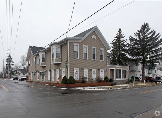
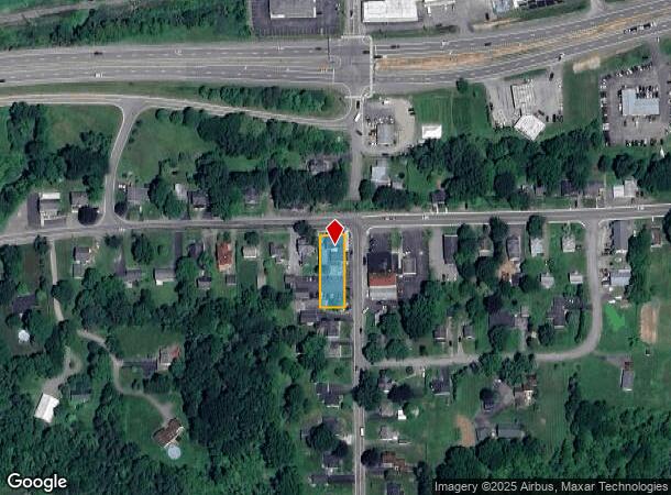
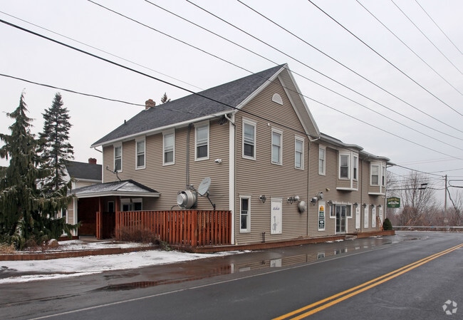
Property Record
1891 Ridge Rd, Webster, NY 14580
NEARBY LISTINGS FOR SALE OR LEASE
-
-
View all Webster listings for sale on LoopNet.com
Property Detail
1891 Ridge Rd
265489-081-010-0001-036-000
0001-14-04
Commercialofficeresidentialmixeduse
Monroe
X
New York
36055C0232G
36.000
2025
0.50 AC
2024
Northeast
011401
Rochester
7,128 SF
Rochester, NY
DEMOGRAPHICS near 1891 Ridge Rd
1 Mile
3 Mile
5 Mile
2024 Total Population
1,111
15,021
42,064
2029 Population
1,086
14,767
41,504
Pop Growth 2024-2029
(2.25%)
(1.69%)
(1.33%)
Average Age
40
42
44
2024 Total Households
401
6,053
17,666
HH Growth 2024-2029
(2.00%)
(1.73%)
(1.40%)
Median Household Inc
$105,542
$85,094
$84,496
Avg Household Size
2.70
2.50
2.30
2024 Avg HH Vehicles
2.00
2.00
2.00
Median Home Value
$210,569
$239,916
$234,249
Median Year Built
1982
1985
1984
Nearby Places
- Restaurants
- Banks
- Shops
- Fitness
- Groceries
PUBLIC TRANSPORTATION
AIRPORT
Frederick Douglass/Greater Rochester International
DRIVE
WALK
Distance
Frederick Douglass/Greater Rochester International
30 min
19.6 mi
Freight Ports
Albany, NY Port
DRIVE
WALK
Distance
Albany, NY Port
261 min
212.0 mi
Nearby Properties
Address
Land Use
TOTAL SIZE
Lot Size
Zoning
Address
Land Use
TOTAL SIZE
Lot Size
Zoning
120,974 SF
42.70 AC
06
Address
Land Use
TOTAL SIZE
Lot Size
Zoning
78,944 SF
379.99 AC
06 - INDUS
Address
Land Use
TOTAL SIZE
Lot Size
Zoning
5,400 SF
37.90 AC
Address
Land Use
TOTAL SIZE
Lot Size
Zoning
10,573 SF
84.26 AC
Address
Land Use
TOTAL SIZE
Lot Size
Zoning
185,429 SF
5.81 AC
Address
Land Use
TOTAL SIZE
Lot Size
Zoning
150,591 SF
18.18 AC
I
Address
Land Use
TOTAL SIZE
Lot Size
Zoning
129,951 SF
29.16 AC
Address
Land Use
TOTAL SIZE
Lot Size
Zoning
19,314 SF
8.90 AC
53710
Address
Land Use
TOTAL SIZE
Lot Size
Zoning
130,843 SF
18 AC
06 - INDUS
Address
Land Use
TOTAL SIZE
Lot Size
Zoning
87,462 SF
9.13 AC
06 - INDUS
Address
Land Use
TOTAL SIZE
Lot Size
Zoning
8,243 SF
3.41 AC
Address
Land Use
TOTAL SIZE
Lot Size
Zoning
110.41 AC
Address
Land Use
TOTAL SIZE
Lot Size
Zoning
113,774 SF
8.97 AC
Address
Land Use
TOTAL SIZE
Lot Size
Zoning
30,064 SF
119.63 AC
I
Address
Land Use
TOTAL SIZE
Lot Size
Zoning
74,400 SF
6.65 AC
I
Address
Land Use
TOTAL SIZE
Lot Size
Zoning
62,248 SF
20 AC
Address
Land Use
TOTAL SIZE
Lot Size
Zoning
39,207 SF
74.80 AC
06 - INDUS
Address
Land Use
TOTAL SIZE
Lot Size
Zoning
68,810 SF
21.30 AC
27630
Address
Land Use
TOTAL SIZE
Lot Size
Zoning
23,837 SF
0.58 AC
Address
Land Use
TOTAL SIZE
Lot Size
Zoning
10.09 AC
AE/I
Address
Land Use
TOTAL SIZE
Lot Size
Zoning
5,416 SF
9.14 AC
Address
Land Use
TOTAL SIZE
Lot Size
Zoning
27,332 SF
2.85 AC
B
Address
Land Use
TOTAL SIZE
Lot Size
Zoning
17,194 SF
20.60 AC
Address
Land Use
TOTAL SIZE
Lot Size
Zoning
132,328 SF
13.83 AC
06 - INDUS
Address
Land Use
TOTAL SIZE
Lot Size
Zoning
0.90 AC
I
Address
Land Use
TOTAL SIZE
Lot Size
Zoning
80,100 SF
5 AC
I
Address
Land Use
TOTAL SIZE
Lot Size
Zoning
16,369 SF
9.19 AC
Address
Land Use
TOTAL SIZE
Lot Size
Zoning
92,470 SF
25.92 AC
06 - INDUS
Address
Land Use
TOTAL SIZE
Lot Size
Zoning
8.19 AC
PD
Address
Land Use
TOTAL SIZE
Lot Size
Zoning
54,600 SF
5.59 AC
I
The World's #1 Commercial Real Estate Marketplace
Connect with us
© 2025 CoStar Group
The information above has been obtained from sources believed reliable. While we do not doubt its accuracy we have not verified it and make no guarantee, warranty or representation about it. It is your responsibility to independently confirm its accuracy and completeness. Any projections, opinions, assumptions, or estimates used are for example only and do not represent the current or future performance of the property. The value of this transaction to you depends on tax and other factors which should be evaluated by your tax, financial, and legal advisors. You and your advisors should conduct a careful, independent investigation of the property to determine to your satisfaction the suitability of the property for your needs.