Property Record
18920 Fm Rr 1431, Leander, TX 78645

Property Detail
18920 Fm Rr 1431
Austin-Round Rock-San Marcos, TX
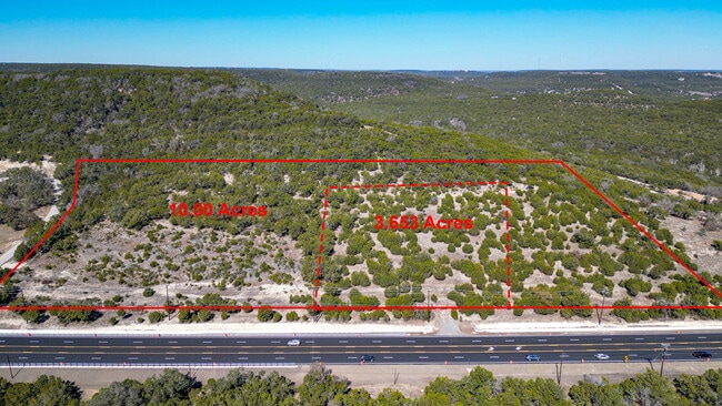
ABS 383 SUR 607 HEARTT CHAS S ACR 3.653
182174
TRAVIS
Vacantlandnec
Texas
B and X Area of moderate flood hazard, usually the area between the limits of the 100-year and 500-year floods.
3.65 AC
2025
Far Northwest
2025
Austin
037600
NEARBY LISTINGS FOR SALE OR LEASE
DEMOGRAPHICS near 18920 Fm Rr 1431
1 mile
3 mile
5 mile
2025 Total Population
557
8,016
27,201
2030 Population
596
8,617
29,261
Pop Growth 2025-2030
+ 7.00%
+ 7.50%
+ 7.57%
Average Age
49
47
45
2025 Total Households
228
3,311
10,523
HH Growth 2025-2030
+ 7.89%
+ 8.15%
+ 8.18%
Median Household Inc
$117,307
$103,380
$133,979
Avg Household Size
2.40
2.40
2.60
2025 Avg HH Vehicles
3.00
2.00
2.00
Median Home Value
$782,738
$631,113
$694,361
Median Year Built
2003
2001
2007
Nearby Places
Map Layers
Map Styles
 Street
 Aerial
Layers
 Traffic
 Biking
Places
Listings with unknown addresses are not visible on the map
- Restaurants
- Banks
- Shops
- Fitness
- Groceries
PUBLIC TRANSPORTATION
AIRPORT
Austin-Bergstrom International
Drive
Walk
Distance
Austin-Bergstrom International
59 min
41.2 mi
Freight Ports
Calhoun Port
Drive
Walk
Distance
Calhoun Port
225 min
184.7 mi
SALE & LEASE HISTORY
LISTING DATE
SALE/LEASE

Feb 15, 2025
For Sale
Nearby Properties
Address
Land Use
TOTAL SIZE
Lot Size
Zoning
Address
Land Use
TOTAL SIZE
Lot Size
Zoning
2,327 SF
810.41 AC
Address
Land Use
TOTAL SIZE
Lot Size
Zoning
670.57 AC
Address
Land Use
TOTAL SIZE
Lot Size
Zoning
323.39 AC
Address
Land Use
TOTAL SIZE
Lot Size
Zoning
22.34 AC
Address
Land Use
TOTAL SIZE
Lot Size
Zoning
2,366 SF
6.68 AC
Address
Land Use
TOTAL SIZE
Lot Size
Zoning
69,163 SF
4.42 AC
Address
Land Use
TOTAL SIZE
Lot Size
Zoning
14,351 SF
2.74 AC
Address
Land Use
TOTAL SIZE
Lot Size
Zoning
2,744 SF
299.90 AC
Address
Land Use
TOTAL SIZE
Lot Size
Zoning
560 SF
38.01 AC
Address
Land Use
TOTAL SIZE
Lot Size
Zoning
17,596 SF
2.15 AC
Address
Land Use
TOTAL SIZE
Lot Size
Zoning
584.77 AC
Address
Land Use
TOTAL SIZE
Lot Size
Zoning
46,955 SF
3.09 AC
Address
Land Use
TOTAL SIZE
Lot Size
Zoning
22,198 SF
8.56 AC
Address
Land Use
TOTAL SIZE
Lot Size
Zoning
107.45 AC
Address
Land Use
TOTAL SIZE
Lot Size
Zoning
2,780 SF
2.76 AC
Address
Land Use
TOTAL SIZE
Lot Size
Zoning
26.88 AC
Address
Land Use
TOTAL SIZE
Lot Size
Zoning
7.71 AC
Address
Land Use
TOTAL SIZE
Lot Size
Zoning
5.48 AC
Address
Land Use
TOTAL SIZE
Lot Size
Zoning
3.07 AC
Address
Land Use
TOTAL SIZE
Lot Size
Zoning
138.92 AC
Address
Land Use
TOTAL SIZE
Lot Size
Zoning
3.50 AC
Address
Land Use
TOTAL SIZE
Lot Size
Zoning
21,739 SF
7.45 AC
Address
Land Use
TOTAL SIZE
Lot Size
Zoning
22,576 SF
2.48 AC
Address
Land Use
TOTAL SIZE
Lot Size
Zoning
107.31 AC
Address
Land Use
TOTAL SIZE
Lot Size
Zoning
7,045 SF
1.19 AC
Address
Land Use
TOTAL SIZE
Lot Size
Zoning
4,834 SF
7.18 AC
Address
Land Use
TOTAL SIZE
Lot Size
Zoning
62.62 AC
Address
Land Use
TOTAL SIZE
Lot Size
Zoning
13,000 SF
1.60 AC
Address
Land Use
TOTAL SIZE
Lot Size
Zoning
10,852 SF
1.22 AC
Address
Land Use
TOTAL SIZE
Lot Size
Zoning
8,692 SF
3.52 AC
The World's #1 Commercial Real Estate Marketplace
Connect with us
© 2026 CoStar Group
The information above has been obtained from sources believed reliable. While we do not doubt its accuracy we have not verified it and make no guarantee, warranty or representation about it. It is your responsibility to independently confirm its accuracy and completeness. Any projections, opinions, assumptions, or estimates used are for example only and do not represent the current or future performance of the property. The value of this transaction to you depends on tax and other factors which should be evaluated by your tax, financial, and legal advisors. You and your advisors should conduct a careful, independent investigation of the property to determine to your satisfaction the suitability of the property for your needs.