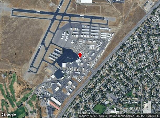
Property Record
1893 Airport Way, Richland, WA 99354
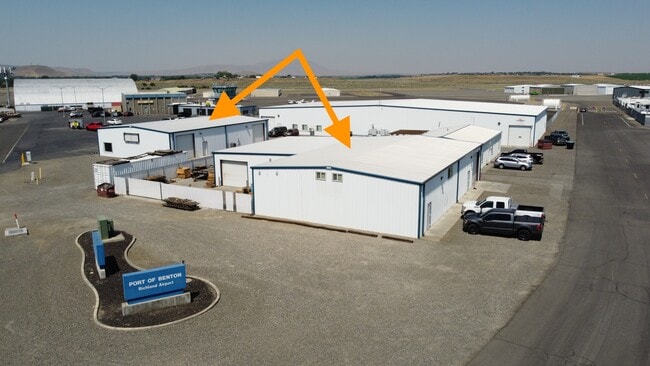
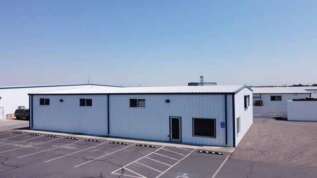
This Property Is For Sale
Current Lease Availabilities
NEARBY LISTINGS FOR SALE OR LEASE
Property Detail
1893 Airport Way
Kennewick-Richland, WA
SECTION 34 TOWNSHIP 10 RANGE 28 QUARTER SWTHAT PORTION OF THE SOUTHWEST QUARTER OF SECTION 34 TOWNSHIP 10 NORTH RANGE 28 EAST W.M. CITY OF RICHLAND BENTON COUNTY WASHINGTON DESCRIBED AS FOLLOWS COMMENCING AT MONUMENT PB 1OW AS SHOWN ON THE
834083000001029
Benton
Miningfacilityoilgasmineralpreciousmetals
Washington
2024
0.70 AC
2024
Yakima/Kennewick
010201
Other Market Areas
10,244 SF
DEMOGRAPHICS near 1893 Airport Way
1 Mile
3 Mile
5 Mile
2024 Total Population
7,531
44,897
80,904
2029 Population
7,975
48,157
87,230
Pop Growth 2024-2029
+ 5.90%
+ 7.26%
+ 7.82%
Average Age
38
39
39
2024 Total Households
3,025
17,858
30,389
HH Growth 2024-2029
+ 6.02%
+ 7.18%
+ 7.69%
Median Household Inc
$69,731
$83,146
$99,029
Avg Household Size
2.40
2.50
2.60
2024 Avg HH Vehicles
2.00
2.00
2.00
Median Home Value
$281,141
$334,652
$368,617
Median Year Built
1964
1973
1993
Nearby Places
- Restaurants
- Banks
- Shops
- Fitness
- Groceries
PUBLIC TRANSPORTATION
AIRPORT
Tri-Cities
DRIVE
WALK
Distance
Tri-Cities
20 min
13.4 mi
Freight Ports
Port of Tacoma
DRIVE
WALK
Distance
Port of Tacoma
261 min
214.1 mi
Nearby Properties
Address
Land Use
TOTAL SIZE
Lot Size
Zoning
Address
Land Use
TOTAL SIZE
Lot Size
Zoning
650,794 SF
55.19 AC
Address
Land Use
TOTAL SIZE
Lot Size
Zoning
351,518 SF
16.01 AC
Address
Land Use
TOTAL SIZE
Lot Size
Zoning
14,514 SF
160 AC
Address
Land Use
TOTAL SIZE
Lot Size
Zoning
562,186 SF
7.61 AC
Address
Land Use
TOTAL SIZE
Lot Size
Zoning
305,328 SF
83.37 AC
Address
Land Use
TOTAL SIZE
Lot Size
Zoning
12,866 SF
44.02 AC
Address
Land Use
TOTAL SIZE
Lot Size
Zoning
245,782 SF
10 AC
RICHLAND -
Address
Land Use
TOTAL SIZE
Lot Size
Zoning
306,563 SF
14.60 AC
Address
Land Use
TOTAL SIZE
Lot Size
Zoning
277,559 SF
30 AC
Address
Land Use
TOTAL SIZE
Lot Size
Zoning
201,040 SF
4.24 AC
Address
Land Use
TOTAL SIZE
Lot Size
Zoning
143,592 SF
6.86 AC
RICHLAND -
Address
Land Use
TOTAL SIZE
Lot Size
Zoning
719,130 SF
75 AC
RICHLAND -
Address
Land Use
TOTAL SIZE
Lot Size
Zoning
428,225 SF
12.60 AC
Address
Land Use
TOTAL SIZE
Lot Size
Zoning
351,217 SF
60.86 AC
Address
Land Use
TOTAL SIZE
Lot Size
Zoning
236,556 SF
11.34 AC
Address
Land Use
TOTAL SIZE
Lot Size
Zoning
47,160 SF
14.28 AC
Address
Land Use
TOTAL SIZE
Lot Size
Zoning
185,302 SF
9.13 AC
Address
Land Use
TOTAL SIZE
Lot Size
Zoning
118,956 SF
30.48 AC
Address
Land Use
TOTAL SIZE
Lot Size
Zoning
220,970 SF
1.28 AC
Address
Land Use
TOTAL SIZE
Lot Size
Zoning
106,500 SF
3.83 AC
Address
Land Use
TOTAL SIZE
Lot Size
Zoning
90,520 SF
4.32 AC
RICHLAND -
Address
Land Use
TOTAL SIZE
Lot Size
Zoning
94,714 SF
5.22 AC
Address
Land Use
TOTAL SIZE
Lot Size
Zoning
113,052 SF
3.32 AC
Address
Land Use
TOTAL SIZE
Lot Size
Zoning
81,497 SF
16.69 AC
Address
Land Use
TOTAL SIZE
Lot Size
Zoning
69,488 SF
1.69 AC
Address
Land Use
TOTAL SIZE
Lot Size
Zoning
233,709 SF
39.16 AC
Address
Land Use
TOTAL SIZE
Lot Size
Zoning
170,307 SF
14.15 AC
Address
Land Use
TOTAL SIZE
Lot Size
Zoning
69,697 SF
16.83 AC
Address
Land Use
TOTAL SIZE
Lot Size
Zoning
102,146 SF
40 AC
Address
Land Use
TOTAL SIZE
Lot Size
Zoning
116,318 SF
2.74 AC
The World's #1 Commercial Real Estate Marketplace
Connect with us
© 2025 CoStar Group
The information above has been obtained from sources believed reliable. While we do not doubt its accuracy we have not verified it and make no guarantee, warranty or representation about it. It is your responsibility to independently confirm its accuracy and completeness. Any projections, opinions, assumptions, or estimates used are for example only and do not represent the current or future performance of the property. The value of this transaction to you depends on tax and other factors which should be evaluated by your tax, financial, and legal advisors. You and your advisors should conduct a careful, independent investigation of the property to determine to your satisfaction the suitability of the property for your needs.