Property Record
18848 Pearl Rd, Strongsville, OH 44136

This Property Is For Sale
NEARBY LISTINGS FOR SALE OR LEASE
Property Detail
18848 Pearl Rd
Cleveland
Ac Pt Add
Cleveland-Elyria, OH
60 SP 242FT NP FF 132.00 D 400.00 1.1761 AC PT ADDED TO ROAD 2014 SR
394-31-010
Cuyahoga
Residentialacreage
Ohio
2024
60
2024
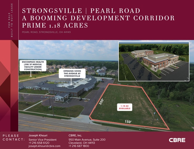
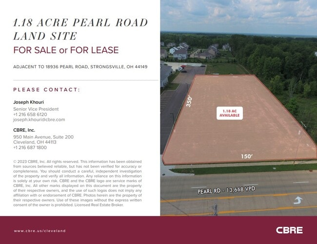
1.18 AC
186206
Southwest
1,222 SF
DEMOGRAPHICS near 18848 Pearl Rd
1 Mile
3 Mile
5 Mile
2024 Total Population
8,795
54,959
109,015
2029 Population
8,605
54,493
108,325
Pop Growth 2024-2029
(2.16%)
(0.85%)
(0.63%)
Average Age
43
43
43
2024 Total Households
3,296
21,443
43,991
HH Growth 2024-2029
(2.15%)
(0.95%)
(0.82%)
Median Household Inc
$111,729
$94,004
$87,824
Avg Household Size
2.60
2.50
2.40
2024 Avg HH Vehicles
2.00
2.00
2.00
Median Home Value
$276,845
$238,432
$242,118
Median Year Built
1986
1981
1981
Nearby Places
Map Layers
Map Styles
 Street
 Aerial
- Restaurants
- Banks
- Shops
- Fitness
- Groceries
PUBLIC TRANSPORTATION
AIRPORT
Cleveland-Hopkins International
DRIVE
WALK
Distance
Cleveland-Hopkins International
25 min
13.9 mi
Freight Ports
Port of Toledo
DRIVE
WALK
Distance
Port of Toledo
130 min
106.8 mi
Nearby Properties
Address
Land Use
TOTAL SIZE
Lot Size
Zoning
Address
Land Use
TOTAL SIZE
Lot Size
Zoning
127,666 SF
2.79 AC
Address
Land Use
TOTAL SIZE
Lot Size
Zoning
830,541 SF
51.19 AC
SC
Address
Land Use
TOTAL SIZE
Lot Size
Zoning
184,998 SF
20.43 AC
PF
Address
Land Use
TOTAL SIZE
Lot Size
Zoning
345,524 SF
107.02 AC
PF
Address
Land Use
TOTAL SIZE
Lot Size
Zoning
62,681 SF
5.48 AC
OB
Address
Land Use
TOTAL SIZE
Lot Size
Zoning
127,666 SF
9.53 AC
Address
Land Use
TOTAL SIZE
Lot Size
Zoning
143,074 SF
25.34 AC
PDA-2
Address
Land Use
TOTAL SIZE
Lot Size
Zoning
288,114 SF
27.52 AC
GB
Address
Land Use
TOTAL SIZE
Lot Size
Zoning
230,291 SF
17.35 AC
Address
Land Use
TOTAL SIZE
Lot Size
Zoning
437,700 SF
36.09 AC
GI
Address
Land Use
TOTAL SIZE
Lot Size
Zoning
139,914 SF
17.98 AC
MS
Address
Land Use
TOTAL SIZE
Lot Size
Zoning
124,195 SF
54.96 AC
PF
Address
Land Use
TOTAL SIZE
Lot Size
Zoning
310,080 SF
28.30 AC
GI
Address
Land Use
TOTAL SIZE
Lot Size
Zoning
34,005 SF
514.86 AC
PF
Address
Land Use
TOTAL SIZE
Lot Size
Zoning
120,478 SF
17.45 AC
Address
Land Use
TOTAL SIZE
Lot Size
Zoning
180,606 SF
10.99 AC
Address
Land Use
TOTAL SIZE
Lot Size
Zoning
149,184 SF
14.09 AC
PDA-2
Address
Land Use
TOTAL SIZE
Lot Size
Zoning
185,284 SF
10.84 AC
Address
Land Use
TOTAL SIZE
Lot Size
Zoning
147,287 SF
15.58 AC
MS
Address
Land Use
TOTAL SIZE
Lot Size
Zoning
83,961 SF
6.58 AC
GB
Address
Land Use
TOTAL SIZE
Lot Size
Zoning
128,979 SF
3.87 AC
R1-75
Address
Land Use
TOTAL SIZE
Lot Size
Zoning
96,685 SF
16.21 AC
R-RS
Address
Land Use
TOTAL SIZE
Lot Size
Zoning
8,316 SF
14.90 AC
Address
Land Use
TOTAL SIZE
Lot Size
Zoning
195.95 AC
PF
Address
Land Use
TOTAL SIZE
Lot Size
Zoning
62,070 SF
18.43 AC
GB
Address
Land Use
TOTAL SIZE
Lot Size
Zoning
95,159 SF
10.97 AC
PF
Address
Land Use
TOTAL SIZE
Lot Size
Zoning
72,949 SF
10.07 AC
SC
Address
Land Use
TOTAL SIZE
Lot Size
Zoning
119,880 SF
11.61 AC
GI
Address
Land Use
TOTAL SIZE
Lot Size
Zoning
247,299 SF
23.38 AC
GI
Address
Land Use
TOTAL SIZE
Lot Size
Zoning
271,272 SF
25.13 AC
GI
The World's #1 Commercial Real Estate Marketplace
Connect with us
© 2026 CoStar Group
The information above has been obtained from sources believed reliable. While we do not doubt its accuracy we have not verified it and make no guarantee, warranty or representation about it. It is your responsibility to independently confirm its accuracy and completeness. Any projections, opinions, assumptions, or estimates used are for example only and do not represent the current or future performance of the property. The value of this transaction to you depends on tax and other factors which should be evaluated by your tax, financial, and legal advisors. You and your advisors should conduct a careful, independent investigation of the property to determine to your satisfaction the suitability of the property for your needs.