Property Record
Access Undetermined, Fort Myers, FL 33908
NEARBY LISTINGS FOR SALE OR LEASE
Property Detail
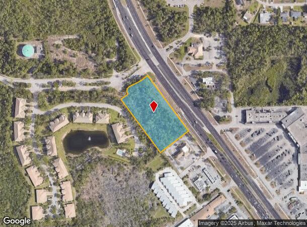
Access Undetermined
Cape Coral-Fort Myers, FL
S. 41 Corridor
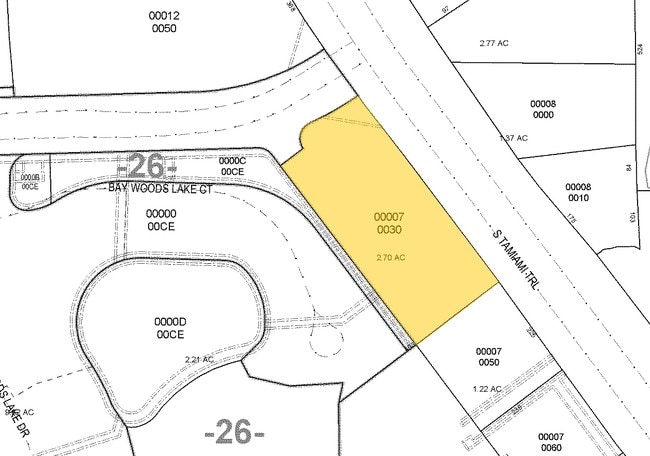
17-46-25-00-00007.0030
BEG AT A POINT OF INTERSECTION OF SW R/W OF TAMIAMI TRAIL WITH W LI OF LESS OR 3553 PG 4860 LESS SUBD
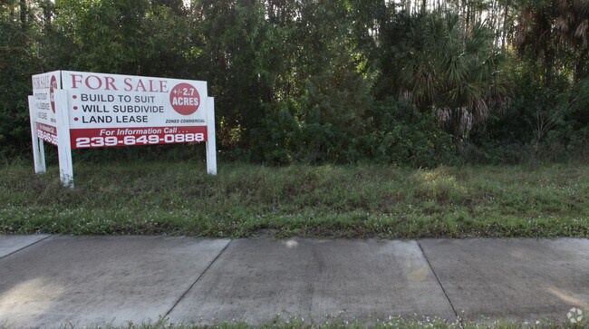
Commercialacreage
Lee
AE
Florida
12071C0579G
3
2024
2.43 AC
2025
S Ft Myers/San Carlos
001916
Southwest Florida
DEMOGRAPHICS near Access Undetermined
1 Mile
3 Mile
5 Mile
2024 Total Population
5,849
45,283
86,827
2029 Population
6,838
53,479
103,450
Pop Growth 2024-2029
+ 16.91%
+ 18.10%
+ 19.14%
Average Age
40
45
49
2024 Total Households
2,268
18,869
38,536
HH Growth 2024-2029
+ 16.49%
+ 17.95%
+ 19.00%
Median Household Inc
$62,189
$75,480
$81,448
Avg Household Size
2.50
2.30
2.20
2024 Avg HH Vehicles
2.00
2.00
2.00
Median Home Value
$268,405
$279,776
$322,213
Median Year Built
1988
1994
1999
Nearby Places
Map Layers
Map Styles
 Street
 Aerial
- Restaurants
- Banks
- Shops
- Fitness
- Groceries
PUBLIC TRANSPORTATION
AIRPORT
Southwest Florida International
DRIVE
WALK
Distance
Southwest Florida International
22 min
12.6 mi
Punta Gorda
DRIVE
WALK
Distance
Punta Gorda
51 min
38.8 mi
SALE & LEASE HISTORY
LISTING DATE
SALE/LEASE

Sep 24, 2016
For Sale
Sep 24, 2016
For Sale
Nearby Properties
Address
Land Use
TOTAL SIZE
Lot Size
Zoning
Address
Land Use
TOTAL SIZE
Lot Size
Zoning
100,557 SF
17.66 AC
CPD
Address
Land Use
TOTAL SIZE
Lot Size
Zoning
395,259 SF
16.56 AC
MPD
Address
Land Use
TOTAL SIZE
Lot Size
Zoning
385,229 SF
16.69 AC
RPD
Address
Land Use
TOTAL SIZE
Lot Size
Zoning
462,334 SF
32.45 AC
MPD
Address
Land Use
TOTAL SIZE
Lot Size
Zoning
369,577 SF
16.39 AC
RPD
Address
Land Use
TOTAL SIZE
Lot Size
Zoning
345,170 SF
21.32 AC
RPD
Address
Land Use
TOTAL SIZE
Lot Size
Zoning
24,552 SF
71.20 AC
IPD
Address
Land Use
TOTAL SIZE
Lot Size
Zoning
34.63 AC
AG-2
Address
Land Use
TOTAL SIZE
Lot Size
Zoning
245,356 SF
12.54 AC
MPD
Address
Land Use
TOTAL SIZE
Lot Size
Zoning
Address
Land Use
TOTAL SIZE
Lot Size
Zoning
270,752 SF
45.08 AC
IPD
Address
Land Use
TOTAL SIZE
Lot Size
Zoning
14.42 AC
RPD
Address
Land Use
TOTAL SIZE
Lot Size
Zoning
263,160 SF
19.96 AC
IPD
Address
Land Use
TOTAL SIZE
Lot Size
Zoning
198,225 SF
28.77 AC
IPD
Address
Land Use
TOTAL SIZE
Lot Size
Zoning
79,833 SF
9.16 AC
Address
Land Use
TOTAL SIZE
Lot Size
Zoning
129,016 SF
9.76 AC
CPD
Address
Land Use
TOTAL SIZE
Lot Size
Zoning
123,815 SF
23.62 AC
CPD
Address
Land Use
TOTAL SIZE
Lot Size
Zoning
21.13 AC
H
Address
Land Use
TOTAL SIZE
Lot Size
Zoning
118,193 SF
11.05 AC
CPD
Address
Land Use
TOTAL SIZE
Lot Size
Zoning
122,339 SF
19.39 AC
RPD
Address
Land Use
TOTAL SIZE
Lot Size
Zoning
125,656 SF
20.82 AC
AG-2
Address
Land Use
TOTAL SIZE
Lot Size
Zoning
277,794 SF
47.85 AC
IPD
Address
Land Use
TOTAL SIZE
Lot Size
Zoning
89,049 SF
11.59 AC
CPD
Address
Land Use
TOTAL SIZE
Lot Size
Zoning
95,928 SF
10 AC
IPD
Address
Land Use
TOTAL SIZE
Lot Size
Zoning
206,959 SF
29.59 AC
MPD
Address
Land Use
TOTAL SIZE
Lot Size
Zoning
10.10 AC
IPD
Address
Land Use
TOTAL SIZE
Lot Size
Zoning
2.65 AC
CPD
Address
Land Use
TOTAL SIZE
Lot Size
Zoning
97,737 SF
10.67 AC
CPD
Address
Land Use
TOTAL SIZE
Lot Size
Zoning
103,048 SF
19.09 AC
AG-2
Address
Land Use
TOTAL SIZE
Lot Size
Zoning
96,403 SF
3.67 AC
CPD
The World's #1 Commercial Real Estate Marketplace
Connect with us
© 2025 CoStar Group
The information above has been obtained from sources believed reliable. While we do not doubt its accuracy we have not verified it and make no guarantee, warranty or representation about it. It is your responsibility to independently confirm its accuracy and completeness. Any projections, opinions, assumptions, or estimates used are for example only and do not represent the current or future performance of the property. The value of this transaction to you depends on tax and other factors which should be evaluated by your tax, financial, and legal advisors. You and your advisors should conduct a careful, independent investigation of the property to determine to your satisfaction the suitability of the property for your needs.