Property Record
18975 Clare Rd, Gardner, KS 66030
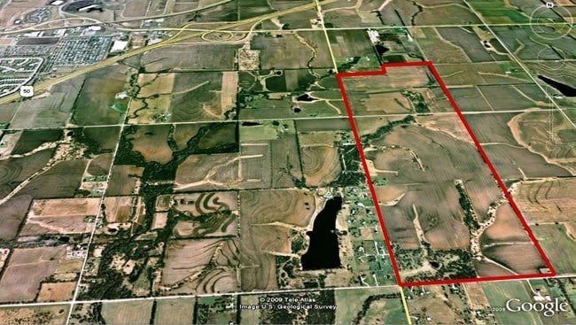

Property Detail
18975 Clare Rd
9F231433-2001
33-14-23 W 1/2 SEC EX E 208.71 S 208.71 IN SE CR & EX S 1/2 SW 1/4 NW 1/4 EX .282 AC IN RD & EX .178 AC IN RD 298.54 ACS M/L
Farms
Johnson
RUR
Kansas
2024
298.19 AC
2025
South Johnson County
053801
Kansas City
10,118 SF
Kansas City, MO-KS
NEARBY LISTINGS FOR SALE OR LEASE
DEMOGRAPHICS near 18975 Clare Rd
1 mile
3 mile
5 mile
2025 Total Population
187
10,428
40,713
2030 Population
203
10,903
42,501
Pop Growth 2025-2030
+ 8.56%
+ 4.56%
+ 4.39%
Average Age
41
37
37
2025 Total Households
68
3,602
13,951
HH Growth 2025-2030
+ 7.35%
+ 4.91%
+ 4.63%
Median Household Inc
$104,167
$78,289
$97,909
Avg Household Size
2.70
2.70
2.80
2025 Avg HH Vehicles
3.00
2.00
2.00
Median Home Value
$499,999
$290,072
$330,145
Median Year Built
2005
2000
2000
Nearby Places
Map Layers
Map Styles
 Street
 Aerial
Transit
 Traffic
 Biking
Places
Listings with unknown addresses are not visible on the map
- Restaurants
- Banks
- Shops
- Fitness
- Groceries
Nearby Properties
Address
Land Use
TOTAL SIZE
Lot Size
Zoning
Address
Land Use
TOTAL SIZE
Lot Size
Zoning
1,060,732 SF
57.62 AC
MP-2
Address
Land Use
TOTAL SIZE
Lot Size
Zoning
71,086 SF
22.76 AC
R-3
Address
Land Use
TOTAL SIZE
Lot Size
Zoning
648,070 SF
33.46 AC
MP-1
Address
Land Use
TOTAL SIZE
Lot Size
Zoning
522,478 SF
45.72 AC
PEC3
Address
Land Use
TOTAL SIZE
Lot Size
Zoning
70,643 SF
18.45 AC
RP-1
Address
Land Use
TOTAL SIZE
Lot Size
Zoning
1,107,600 SF
50.97 AC
MP-1
Address
Land Use
TOTAL SIZE
Lot Size
Zoning
88,250 SF
9.82 AC
PEC3
Address
Land Use
TOTAL SIZE
Lot Size
Zoning
73,451 SF
12.58 AC
A
Address
Land Use
TOTAL SIZE
Lot Size
Zoning
688,460 SF
116.12 AC
MP-2
Address
Land Use
TOTAL SIZE
Lot Size
Zoning
10,956 SF
90 AC
PEC3
Address
Land Use
TOTAL SIZE
Lot Size
Zoning
30,994 SF
3.47 AC
C-3
Address
Land Use
TOTAL SIZE
Lot Size
Zoning
41,250 SF
6.01 AC
R-R
Address
Land Use
TOTAL SIZE
Lot Size
Zoning
20,727 SF
20.96 AC
R-3
Address
Land Use
TOTAL SIZE
Lot Size
Zoning
72,000 SF
13.82 AC
R-R
Address
Land Use
TOTAL SIZE
Lot Size
Zoning
203,009 SF
28.85 AC
CP-2
Address
Land Use
TOTAL SIZE
Lot Size
Zoning
309,985 SF
7.40 AC
PEC3
Address
Land Use
TOTAL SIZE
Lot Size
Zoning
52,580 SF
11.65 AC
C-2
Address
Land Use
TOTAL SIZE
Lot Size
Zoning
22,000 SF
4.32 AC
C-1
Address
Land Use
TOTAL SIZE
Lot Size
Zoning
13,422 SF
2.31 AC
C-2
Address
Land Use
TOTAL SIZE
Lot Size
Zoning
32,818 SF
7.55 AC
M-1
Address
Land Use
TOTAL SIZE
Lot Size
Zoning
54,178 SF
3.84 AC
C-2
Address
Land Use
TOTAL SIZE
Lot Size
Zoning
61,540 SF
6.05 AC
C-2
Address
Land Use
TOTAL SIZE
Lot Size
Zoning
17.67 AC
PEC3
Address
Land Use
TOTAL SIZE
Lot Size
Zoning
6,798 SF
2.64 AC
R-1
Address
Land Use
TOTAL SIZE
Lot Size
Zoning
5,828 SF
4.64 AC
C-3
Address
Land Use
TOTAL SIZE
Lot Size
Zoning
99,485 SF
3.46 AC
C-3
Address
Land Use
TOTAL SIZE
Lot Size
Zoning
15,876 SF
6.49 AC
R-1
Address
Land Use
TOTAL SIZE
Lot Size
Zoning
20.32 AC
R-R
Address
Land Use
TOTAL SIZE
Lot Size
Zoning
29,574 SF
3.92 AC
CP-2
The World's #1 Commercial Real Estate Marketplace
Connect with us
© 2026 CoStar Group
The information above has been obtained from sources believed reliable. While we do not doubt its accuracy we have not verified it and make no guarantee, warranty or representation about it. It is your responsibility to independently confirm its accuracy and completeness. Any projections, opinions, assumptions, or estimates used are for example only and do not represent the current or future performance of the property. The value of this transaction to you depends on tax and other factors which should be evaluated by your tax, financial, and legal advisors. You and your advisors should conduct a careful, independent investigation of the property to determine to your satisfaction the suitability of the property for your needs.