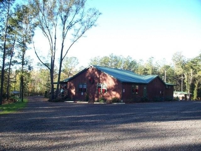
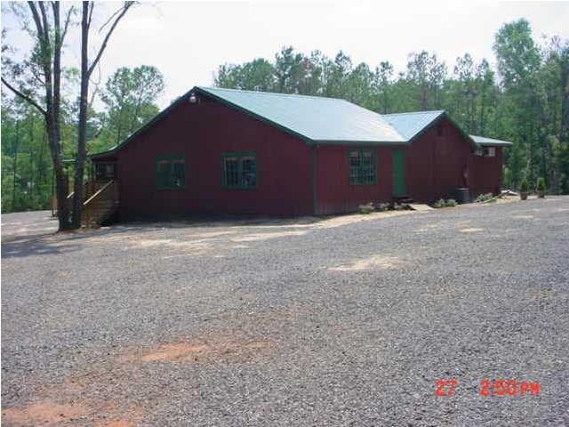
Property Record
18975 S 3Rd St, Citronelle, AL 36522

Property Detail
18975 S 3Rd St
Mobile, AL
LOT 8 BLK 11 ON U S HWY 45 TOWN OF CITRONELLE AS REC IN DBK 79 P 1 BEING 220 FT WIDE & 660 FT DEPTH #SEC 36 T2N R3W #MP04 07
04-07-36-3-000-072
Mobile
Apartment
Alabama
B and X Area of moderate flood hazard, usually the area between the limits of the 100-year and 500-year floods.
8
2025
3.18 AC
2025
Outlying Mobile County
006000
Mobile
3,688 SF
NEARBY LISTINGS FOR SALE OR LEASE
-
-
View all Citronelle listings for sale on LoopNet.com
DEMOGRAPHICS near 18975 S 3Rd St
1 mile
3 mile
5 mile
2025 Total Population
1,892
3,790
5,771
2030 Population
1,913
3,819
5,787
Pop Growth 2025-2030
+ 1.11%
+ 0.77%
+ 0.28%
Average Age
41
40
40
2025 Total Households
759
1,455
2,180
HH Growth 2025-2030
+ 1.05%
+ 0.76%
+ 0.28%
Median Household Inc
$52,936
$54,008
$54,016
Avg Household Size
2.40
2.60
2.60
2025 Avg HH Vehicles
2.00
2.00
2.00
Median Home Value
$178,048
$185,323
$182,847
Median Year Built
1978
1983
1984
Nearby Places
Map Layers
Map Styles
 Street
 Aerial
Layers
 Traffic
 Biking
Places
Listings with unknown addresses are not visible on the map
- Restaurants
- Banks
- Shops
- Fitness
- Groceries
PUBLIC TRANSPORTATION
AIRPORT
Mobile Regional
Drive
Walk
Distance
Mobile Regional
50 min
35.5 mi
Mobile International
Drive
Walk
Distance
Mobile International
52 min
38.7 mi
Freight Ports
Port of Mobile
Drive
Walk
Distance
Port of Mobile
41 min
33.1 mi
Nearby Properties
Address
Land Use
TOTAL SIZE
Lot Size
Zoning
Address
Land Use
TOTAL SIZE
Lot Size
Zoning
102,548 SF
5.80 AC
Address
Land Use
TOTAL SIZE
Lot Size
Zoning
72,002 SF
19.20 AC
Address
Land Use
TOTAL SIZE
Lot Size
Zoning
34,521 SF
3.69 AC
Address
Land Use
TOTAL SIZE
Lot Size
Zoning
31,346 SF
8.48 AC
Address
Land Use
TOTAL SIZE
Lot Size
Zoning
27,364 SF
3.60 AC
Address
Land Use
TOTAL SIZE
Lot Size
Zoning
26,720 SF
8.68 AC
Address
Land Use
TOTAL SIZE
Lot Size
Zoning
77,144 SF
1.88 AC
Address
Land Use
TOTAL SIZE
Lot Size
Zoning
21,420 SF
3.29 AC
Address
Land Use
TOTAL SIZE
Lot Size
Zoning
7,140 SF
2.52 AC
Address
Land Use
TOTAL SIZE
Lot Size
Zoning
23,444 SF
4.92 AC
Address
Land Use
TOTAL SIZE
Lot Size
Zoning
28,625 SF
6.48 AC
Address
Land Use
TOTAL SIZE
Lot Size
Zoning
23,092 SF
5.57 AC
Address
Land Use
TOTAL SIZE
Lot Size
Zoning
9,600 SF
3.15 AC
Address
Land Use
TOTAL SIZE
Lot Size
Zoning
9,504 SF
28 AC
Address
Land Use
TOTAL SIZE
Lot Size
Zoning
10,978 SF
1.52 AC
Address
Land Use
TOTAL SIZE
Lot Size
Zoning
19,936 SF
0.65 AC
Address
Land Use
TOTAL SIZE
Lot Size
Zoning
14,874 SF
2.32 AC
Address
Land Use
TOTAL SIZE
Lot Size
Zoning
7,490 SF
1.31 AC
Address
Land Use
TOTAL SIZE
Lot Size
Zoning
25,816 SF
3.90 AC
Address
Land Use
TOTAL SIZE
Lot Size
Zoning
11,250 SF
6.92 AC
Address
Land Use
TOTAL SIZE
Lot Size
Zoning
3,253 SF
2.65 AC
Address
Land Use
TOTAL SIZE
Lot Size
Zoning
6,652 SF
2.94 AC
Address
Land Use
TOTAL SIZE
Lot Size
Zoning
10,116 SF
3.42 AC
Address
Land Use
TOTAL SIZE
Lot Size
Zoning
3,404 SF
2.08 AC
Address
Land Use
TOTAL SIZE
Lot Size
Zoning
650.81 AC
Address
Land Use
TOTAL SIZE
Lot Size
Zoning
10,152 SF
0.67 AC
Address
Land Use
TOTAL SIZE
Lot Size
Zoning
8,720 SF
6 AC
Address
Land Use
TOTAL SIZE
Lot Size
Zoning
10,466 SF
5.70 AC
Address
Land Use
TOTAL SIZE
Lot Size
Zoning
4,648 SF
1.37 AC
Address
Land Use
TOTAL SIZE
Lot Size
Zoning
4,000 SF
1.75 AC
The World's #1 Commercial Real Estate Marketplace
Connect with us
© 2026 CoStar Group
The information above has been obtained from sources believed reliable. While we do not doubt its accuracy we have not verified it and make no guarantee, warranty or representation about it. It is your responsibility to independently confirm its accuracy and completeness. Any projections, opinions, assumptions, or estimates used are for example only and do not represent the current or future performance of the property. The value of this transaction to you depends on tax and other factors which should be evaluated by your tax, financial, and legal advisors. You and your advisors should conduct a careful, independent investigation of the property to determine to your satisfaction the suitability of the property for your needs.