Property Record
19-25 W Johnson St, Staunton, VA 24401
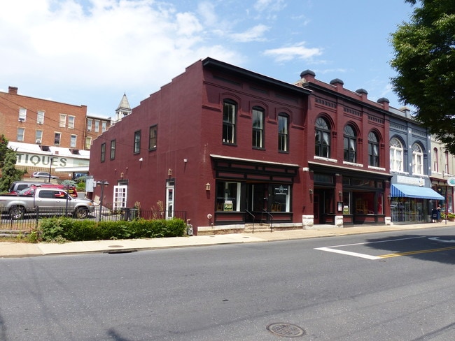
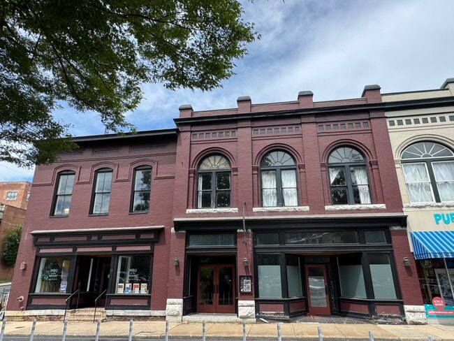
This Property Is For Sale
NEARBY LISTINGS FOR SALE OR LEASE
Property Detail
19-25 W Johnson St
Staunton-Waynesboro, VA
Central City
7606
(LOT 22 BLK DD)
Commercialnec
Staunton City
AE
Virginia
51015C0339E
22
2025
0.04 AC
2025
Staunton & Harrisonburg
000100
Other Market Areas
DEMOGRAPHICS near 19-25 W Johnson St
1 Mile
3 Mile
5 Mile
2024 Total Population
8,704
28,615
36,226
2029 Population
8,932
29,318
37,136
Pop Growth 2024-2029
+ 2.62%
+ 2.46%
+ 2.51%
Average Age
40
43
43
2024 Total Households
3,874
12,669
15,545
HH Growth 2024-2029
+ 2.76%
+ 2.56%
+ 2.62%
Median Household Inc
$50,619
$52,868
$54,904
Avg Household Size
2.00
2.10
2.20
2024 Avg HH Vehicles
2.00
2.00
2.00
Median Home Value
$194,413
$215,962
$225,527
Median Year Built
1953
1966
1970
Nearby Places
- Restaurants
- Banks
- Shops
- Fitness
- Groceries
PUBLIC TRANSPORTATION
AIRPORT
Charlottesville-Albemarle
DRIVE
WALK
Distance
Charlottesville-Albemarle
61 min
46.2 mi
Nearby Properties
Address
Land Use
TOTAL SIZE
Lot Size
Zoning
Address
Land Use
TOTAL SIZE
Lot Size
Zoning
360,085 SF
66.35 AC
I-1
Address
Land Use
TOTAL SIZE
Lot Size
Zoning
43,097 SF
72.85 AC
R3
Address
Land Use
TOTAL SIZE
Lot Size
Zoning
12,720 SF
13.10 AC
HE
Address
Land Use
TOTAL SIZE
Lot Size
Zoning
103,781 SF
32.37 AC
R3
Address
Land Use
TOTAL SIZE
Lot Size
Zoning
20,304 SF
6.67 AC
R4
Address
Land Use
TOTAL SIZE
Lot Size
Zoning
105,828 SF
41.57 AC
GENERAL AG
Address
Land Use
TOTAL SIZE
Lot Size
Zoning
8,004 SF
24.91 AC
MULTI-FAMI
Address
Land Use
TOTAL SIZE
Lot Size
Zoning
32,976 SF
6.20 AC
R4
Address
Land Use
TOTAL SIZE
Lot Size
Zoning
202,650 SF
33.59 AC
B2
Address
Land Use
TOTAL SIZE
Lot Size
Zoning
72,933 SF
8.71 AC
B2
Address
Land Use
TOTAL SIZE
Lot Size
Zoning
18,750 SF
16.51 AC
HE
Address
Land Use
TOTAL SIZE
Lot Size
Zoning
101,384 SF
11.77 AC
R3
Address
Land Use
TOTAL SIZE
Lot Size
Zoning
158,300 SF
30 AC
R2
Address
Land Use
TOTAL SIZE
Lot Size
Zoning
66,309 SF
12.09 AC
B2
Address
Land Use
TOTAL SIZE
Lot Size
Zoning
61,798 SF
8.52 AC
R2
Address
Land Use
TOTAL SIZE
Lot Size
Zoning
100,501 SF
0.32 AC
B2
Address
Land Use
TOTAL SIZE
Lot Size
Zoning
54,507 SF
2.69 AC
B2
Address
Land Use
TOTAL SIZE
Lot Size
Zoning
25,002 SF
10.04 AC
R3
Address
Land Use
TOTAL SIZE
Lot Size
Zoning
56,600 SF
18.89 AC
B2
Address
Land Use
TOTAL SIZE
Lot Size
Zoning
48,904 SF
5.17 AC
P1
Address
Land Use
TOTAL SIZE
Lot Size
Zoning
107,455 SF
5.82 AC
P1
Address
Land Use
TOTAL SIZE
Lot Size
Zoning
121,204 SF
12.99 AC
B2
Address
Land Use
TOTAL SIZE
Lot Size
Zoning
8,640 SF
3.23 AC
R3
Address
Land Use
TOTAL SIZE
Lot Size
Zoning
2,000 SF
79.58 AC
B1
Address
Land Use
TOTAL SIZE
Lot Size
Zoning
77,946 SF
2.67 AC
GENERAL BU
Address
Land Use
TOTAL SIZE
Lot Size
Zoning
41,264 SF
2.70 AC
B2
Address
Land Use
TOTAL SIZE
Lot Size
Zoning
33,661 SF
10.86 AC
GENERAL BU
Address
Land Use
TOTAL SIZE
Lot Size
Zoning
101,604 SF
6.61 AC
R3
Address
Land Use
TOTAL SIZE
Lot Size
Zoning
83,239 SF
8.15 AC
R4
Address
Land Use
TOTAL SIZE
Lot Size
Zoning
107,814 SF
6.21 AC
R4
The World's #1 Commercial Real Estate Marketplace
Connect with us
© 2025 CoStar Group
The information above has been obtained from sources believed reliable. While we do not doubt its accuracy we have not verified it and make no guarantee, warranty or representation about it. It is your responsibility to independently confirm its accuracy and completeness. Any projections, opinions, assumptions, or estimates used are for example only and do not represent the current or future performance of the property. The value of this transaction to you depends on tax and other factors which should be evaluated by your tax, financial, and legal advisors. You and your advisors should conduct a careful, independent investigation of the property to determine to your satisfaction the suitability of the property for your needs.