Property Record
19 Brookside Ave, Pennington, NJ 08534
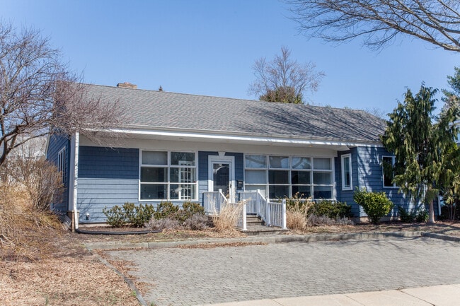

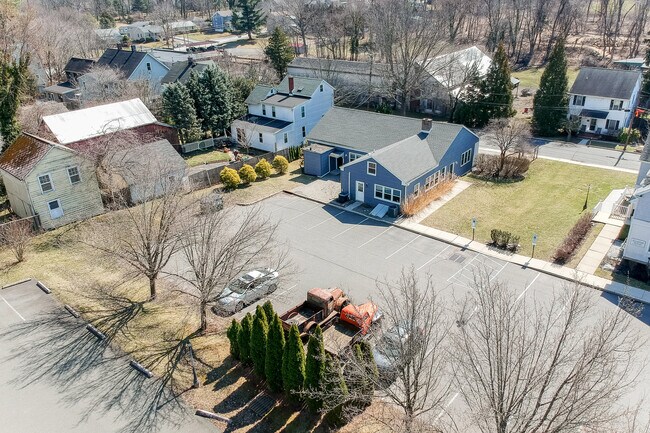
Property Detail
19 Brookside Ave
08-00204-0000-00018
Mercer
Officebuilding
New Jersey
R-80
18
B and X Area of moderate flood hazard, usually the area between the limits of the 100-year and 500-year floods.
0.34 AC
2024
Trenton
2025
Northern New Jersey
003903
Trenton-Princeton, NJ
2,312 SF
NEARBY LISTINGS FOR SALE OR LEASE
DEMOGRAPHICS near 19 Brookside Ave
1 mile
3 mile
5 mile
2025 Total Population
3,922
13,982
53,090
2030 Population
4,053
14,397
54,898
Pop Growth 2025-2030
+ 3.34%
+ 2.97%
+ 3.41%
Average Age
44
43
43
2025 Total Households
1,456
5,165
20,018
HH Growth 2025-2030
+ 3.85%
+ 3.18%
+ 4.13%
Median Household Inc
$159,806
$176,645
$133,191
Avg Household Size
2.60
2.60
2.40
2025 Avg HH Vehicles
2.00
2.00
2.00
Median Home Value
$625,167
$629,879
$483,846
Median Year Built
1963
1982
1977
Nearby Places
Map Layers
Map Styles
 Street
 Aerial
Transit
 Traffic
 Biking
Places
Listings with unknown addresses are not visible on the map
- Restaurants
- Banks
- Shops
- Fitness
- Groceries
PUBLIC TRANSPORTATION
COMMUTER RAIL
West Trenton (R3 - Southeastern Pennsylvania Transportation Authority Regional Rail (SEPTA Regional Rail))
Drive
Walk
Distance
West Trenton (R3 - Southeastern Pennsylvania Transportation Authority Regional Rail (SEPTA Regional Rail))
15 min
8.0 mi
AIRPORT
Trenton Mercer
Drive
Walk
Distance
Trenton Mercer
14 min
5.7 mi
Freight Ports
Port of Philadelphia
Drive
Walk
Distance
Port of Philadelphia
51 min
34.9 mi
SALE & LEASE HISTORY
LISTING DATE
SALE/LEASE

Sep 05, 2018
For Sale
Oct 31, 2018
For Lease
Mar 23, 2022
For Sale
Mar 13, 2020
For Lease
Jun 25, 2019
For Sale
Jun 18, 2021
For Lease
Jun 18, 2021
For Sale
Nearby Properties
Address
Land Use
TOTAL SIZE
Lot Size
Zoning
Address
Land Use
TOTAL SIZE
Lot Size
Zoning
42 AC
R03
Address
Land Use
TOTAL SIZE
Lot Size
Zoning
13.86 AC
OP
Address
Land Use
TOTAL SIZE
Lot Size
Zoning
156.92 AC
R03
Address
Land Use
TOTAL SIZE
Lot Size
Zoning
42 AC
R03
Address
Land Use
TOTAL SIZE
Lot Size
Zoning
13.36 AC
OP
Address
Land Use
TOTAL SIZE
Lot Size
Zoning
0.35 AC
OP
Address
Land Use
TOTAL SIZE
Lot Size
Zoning
7.85 AC
OP
Address
Land Use
TOTAL SIZE
Lot Size
Zoning
6.09 AC
OP
Address
Land Use
TOTAL SIZE
Lot Size
Zoning
8.73 AC
OP
Address
Land Use
TOTAL SIZE
Lot Size
Zoning
Address
Land Use
TOTAL SIZE
Lot Size
Zoning
38.82 AC
R100
Address
Land Use
TOTAL SIZE
Lot Size
Zoning
0.32 AC
OP
Address
Land Use
TOTAL SIZE
Lot Size
Zoning
6.37 AC
OP
Address
Land Use
TOTAL SIZE
Lot Size
Zoning
8.35 AC
OP
Address
Land Use
TOTAL SIZE
Lot Size
Zoning
6.01 AC
OP
Address
Land Use
TOTAL SIZE
Lot Size
Zoning
20.93 AC
HBO
Address
Land Use
TOTAL SIZE
Lot Size
Zoning
0.27 AC
OP
Address
Land Use
TOTAL SIZE
Lot Size
Zoning
9.87 AC
R-5
Address
Land Use
TOTAL SIZE
Lot Size
Zoning
221.99 AC
2ZON
Address
Land Use
TOTAL SIZE
Lot Size
Zoning
107,927 SF
32.87 AC
R-80
Address
Land Use
TOTAL SIZE
Lot Size
Zoning
Address
Land Use
TOTAL SIZE
Lot Size
Zoning
16.34 AC
SC
Address
Land Use
TOTAL SIZE
Lot Size
Zoning
0.34 AC
OP
Address
Land Use
TOTAL SIZE
Lot Size
Zoning
22.37 AC
2ZON
Address
Land Use
TOTAL SIZE
Lot Size
Zoning
0.25 AC
OP
Address
Land Use
TOTAL SIZE
Lot Size
Zoning
7.39 AC
R100
Address
Land Use
TOTAL SIZE
Lot Size
Zoning
0.26 AC
OP
Address
Land Use
TOTAL SIZE
Lot Size
Zoning
495.30 AC
OS
Address
Land Use
TOTAL SIZE
Lot Size
Zoning
0.25 AC
OP
Address
Land Use
TOTAL SIZE
Lot Size
Zoning
43.08 AC
R100
The World's #1 Commercial Real Estate Marketplace
Connect with us
© 2026 CoStar Group
The information above has been obtained from sources believed reliable. While we do not doubt its accuracy we have not verified it and make no guarantee, warranty or representation about it. It is your responsibility to independently confirm its accuracy and completeness. Any projections, opinions, assumptions, or estimates used are for example only and do not represent the current or future performance of the property. The value of this transaction to you depends on tax and other factors which should be evaluated by your tax, financial, and legal advisors. You and your advisors should conduct a careful, independent investigation of the property to determine to your satisfaction the suitability of the property for your needs.