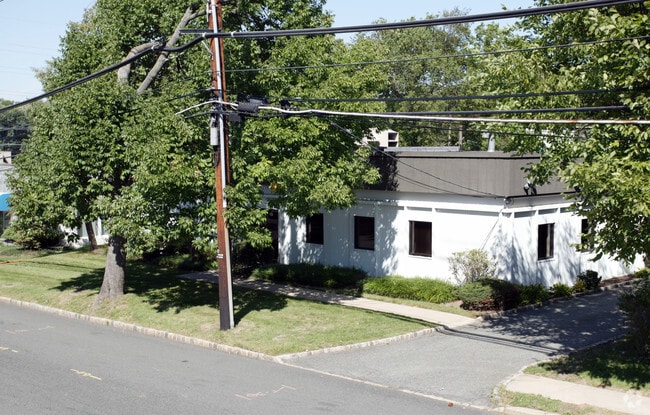
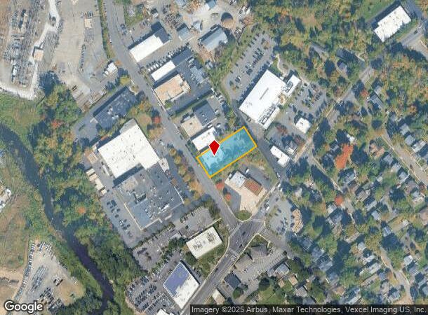
Property Record
19 Chatham Rd, Summit, NJ 07901
NEARBY LISTINGS FOR SALE OR LEASE
Property Detail
19 Chatham Rd
18-00202-0000-00011
Union
Industrialgeneral
New Jersey
X
11
34039C0001F
0.55 AC
2024
Route 78/22 East
2025
Northern New Jersey
037700
Newark, NJ-PA
5,960 SF
DEMOGRAPHICS near 19 Chatham Rd
1 Mile
3 Mile
5 Mile
2024 Total Population
10,587
80,094
188,331
2029 Population
10,547
79,967
187,525
Pop Growth 2024-2029
(0.38%)
(0.16%)
(0.43%)
Average Age
38
40
41
2024 Total Households
3,570
27,623
65,618
HH Growth 2024-2029
(0.50%)
(0.35%)
(0.62%)
Median Household Inc
$189,754
$179,934
$161,582
Avg Household Size
2.90
2.80
2.80
2024 Avg HH Vehicles
2.00
2.00
2.00
Median Home Value
$864,602
$874,903
$768,877
Median Year Built
1950
1958
1959
Nearby Places
Map Layers
Map Styles
 Street
 Aerial
- Restaurants
- Banks
- Shops
- Fitness
- Groceries
PUBLIC TRANSPORTATION
TRANSIT/SUBWAY
Chatham (Morris & Essex Morristown Line - NJ Transit Commuter Rail (NJ Transit))
DRIVE
WALK
Distance
Chatham (Morris & Essex Morristown Line - NJ Transit Commuter Rail (NJ Transit))
3 min
20 min
1.0 mi
COMMUTER RAIL
Chatham (Morris & Essex Morristown Line - NJ Transit Commuter Rail (NJ Transit))
DRIVE
WALK
Distance
Chatham (Morris & Essex Morristown Line - NJ Transit Commuter Rail (NJ Transit))
4 min
20 min
1.0 mi
Summit (Morris & Essex Gladstone Branch - NJ Transit Commuter Rail (NJ Transit), Morris & Essex Morristown Line - NJ Transit Commuter Rail (NJ Transit))
DRIVE
WALK
Distance
Summit (Morris & Essex Gladstone Branch - NJ Transit Commuter Rail (NJ Transit), Morris & Essex Morristown Line - NJ Transit Commuter Rail (NJ Transit))
6 min
1.9 mi
AIRPORT
Newark Liberty International
DRIVE
WALK
Distance
Newark Liberty International
20 min
14.6 mi
LaGuardia
DRIVE
WALK
Distance
LaGuardia
54 min
33.8 mi
John F Kennedy International
DRIVE
WALK
Distance
John F Kennedy International
63 min
42.0 mi
Freight Ports
Maher Terminal
DRIVE
WALK
Distance
Maher Terminal
24 min
15.2 mi
Nearby Properties
Address
Land Use
TOTAL SIZE
Lot Size
Zoning
Address
Land Use
TOTAL SIZE
Lot Size
Zoning
46.18 AC
Address
Land Use
TOTAL SIZE
Lot Size
Zoning
1,968 SF
88.85 AC
PROD
Address
Land Use
TOTAL SIZE
Lot Size
Zoning
Address
Land Use
TOTAL SIZE
Lot Size
Zoning
64.30 AC
MF-4
Address
Land Use
TOTAL SIZE
Lot Size
Zoning
4,595 SF
4.57 AC
M-3
Address
Land Use
TOTAL SIZE
Lot Size
Zoning
7.19 AC
PI
Address
Land Use
TOTAL SIZE
Lot Size
Zoning
4.30 AC
OR-3
Address
Land Use
TOTAL SIZE
Lot Size
Zoning
31.03 AC
R-L
Address
Land Use
TOTAL SIZE
Lot Size
Zoning
19.05 AC
R-2
Address
Land Use
TOTAL SIZE
Lot Size
Zoning
Address
Land Use
TOTAL SIZE
Lot Size
Zoning
296,578 SF
15 AC
Address
Land Use
TOTAL SIZE
Lot Size
Zoning
Address
Land Use
TOTAL SIZE
Lot Size
Zoning
Address
Land Use
TOTAL SIZE
Lot Size
Zoning
17.26 AC
R-L
Address
Land Use
TOTAL SIZE
Lot Size
Zoning
7.52 AC
OR-3
Address
Land Use
TOTAL SIZE
Lot Size
Zoning
2,806 SF
22.79 AC
Address
Land Use
TOTAL SIZE
Lot Size
Zoning
8.32 AC
Address
Land Use
TOTAL SIZE
Lot Size
Zoning
40.90 AC
MF-4
Address
Land Use
TOTAL SIZE
Lot Size
Zoning
9.44 AC
Address
Land Use
TOTAL SIZE
Lot Size
Zoning
22,488 SF
7.67 AC
Address
Land Use
TOTAL SIZE
Lot Size
Zoning
19.14 AC
Address
Land Use
TOTAL SIZE
Lot Size
Zoning
Address
Land Use
TOTAL SIZE
Lot Size
Zoning
24.60 AC
R-L
Address
Land Use
TOTAL SIZE
Lot Size
Zoning
1,889 SF
3.26 AC
R-1
Address
Land Use
TOTAL SIZE
Lot Size
Zoning
128.98 AC
Address
Land Use
TOTAL SIZE
Lot Size
Zoning
28.09 AC
R-3
Address
Land Use
TOTAL SIZE
Lot Size
Zoning
12.32 AC
R-1
Address
Land Use
TOTAL SIZE
Lot Size
Zoning
6,426 SF
12.86 AC
L-1
Address
Land Use
TOTAL SIZE
Lot Size
Zoning
10.14 AC
R-2
Address
Land Use
TOTAL SIZE
Lot Size
Zoning
35.72 AC
PROD
The World's #1 Commercial Real Estate Marketplace
Connect with us
© 2025 CoStar Group
The information above has been obtained from sources believed reliable. While we do not doubt its accuracy we have not verified it and make no guarantee, warranty or representation about it. It is your responsibility to independently confirm its accuracy and completeness. Any projections, opinions, assumptions, or estimates used are for example only and do not represent the current or future performance of the property. The value of this transaction to you depends on tax and other factors which should be evaluated by your tax, financial, and legal advisors. You and your advisors should conduct a careful, independent investigation of the property to determine to your satisfaction the suitability of the property for your needs.