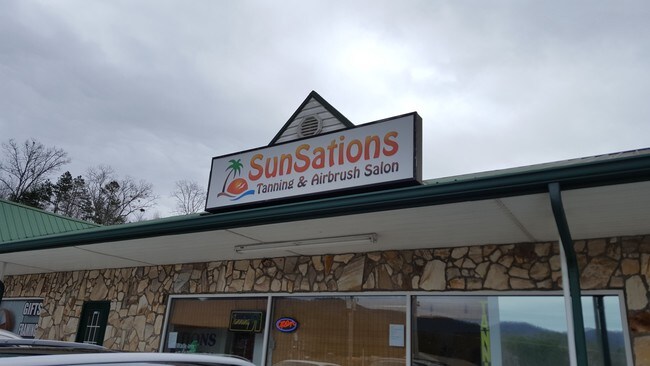
Property Record
19 Cobalt St, Blairsville, GA 30512

NEARBY LISTINGS FOR SALE OR LEASE
-
-
View all Blairsville listings for sale on LoopNet.com
Property Detail
19 Cobalt St
B02-344-C
Comm-Young Harris/Welborne St
Stripcommercialcenter
LD 9 LL 273 TRACT 4
X
Union
13291C0064D
Georgia
2024
1.22 AC
2024
Georgia Northeast
000206
Other Market Areas
12,900 SF
DEMOGRAPHICS near 19 Cobalt St
1 Mile
3 Mile
5 Mile
2024 Total Population
1,082
5,009
11,294
2029 Population
1,263
5,841
13,240
Pop Growth 2024-2029
+ 16.73%
+ 16.61%
+ 17.23%
Average Age
47
49
49
2024 Total Households
424
2,081
4,774
HH Growth 2024-2029
+ 16.51%
+ 16.72%
+ 17.43%
Median Household Inc
$56,999
$46,293
$52,406
Avg Household Size
2.20
2.20
2.20
2024 Avg HH Vehicles
2.00
2.00
2.00
Median Home Value
$218,919
$252,988
$259,214
Median Year Built
1993
1990
1992
Nearby Places
Map Layers
Map Styles
 Street
 Aerial
- Restaurants
- Banks
- Shops
- Fitness
- Groceries
SALE & LEASE HISTORY
LISTING DATE
SALE/LEASE

Mar 16, 2017
For Sale
Nearby Properties
Address
Land Use
TOTAL SIZE
Lot Size
Zoning
Address
Land Use
TOTAL SIZE
Lot Size
Zoning
25,926 SF
62.37 AC
001
Address
Land Use
TOTAL SIZE
Lot Size
Zoning
161,084 SF
11.71 AC
001
Address
Land Use
TOTAL SIZE
Lot Size
Zoning
156,927 SF
24.12 AC
001
Address
Land Use
TOTAL SIZE
Lot Size
Zoning
105,000 SF
Address
Land Use
TOTAL SIZE
Lot Size
Zoning
109,127 SF
7.65 AC
001
Address
Land Use
TOTAL SIZE
Lot Size
Zoning
41,046 SF
6.42 AC
001
Address
Land Use
TOTAL SIZE
Lot Size
Zoning
23,460 SF
22.25 AC
001
Address
Land Use
TOTAL SIZE
Lot Size
Zoning
2,613 SF
9.48 AC
001
Address
Land Use
TOTAL SIZE
Lot Size
Zoning
17,660 SF
3.90 AC
001
Address
Land Use
TOTAL SIZE
Lot Size
Zoning
15,110 SF
12.58 AC
001
Address
Land Use
TOTAL SIZE
Lot Size
Zoning
22,146 SF
30.74 AC
001
Address
Land Use
TOTAL SIZE
Lot Size
Zoning
2,871 SF
15.37 AC
001
Address
Land Use
TOTAL SIZE
Lot Size
Zoning
119,785 SF
14.68 AC
001
Address
Land Use
TOTAL SIZE
Lot Size
Zoning
78,816 SF
14.83 AC
001
Address
Land Use
TOTAL SIZE
Lot Size
Zoning
7,374 SF
9.39 AC
001
Address
Land Use
TOTAL SIZE
Lot Size
Zoning
62,500 SF
4.87 AC
001
Address
Land Use
TOTAL SIZE
Lot Size
Zoning
38,795 SF
5.20 AC
001
Address
Land Use
TOTAL SIZE
Lot Size
Zoning
93,900 SF
10.45 AC
Address
Land Use
TOTAL SIZE
Lot Size
Zoning
24,896 SF
7.20 AC
Address
Land Use
TOTAL SIZE
Lot Size
Zoning
17,801 SF
25.11 AC
001
Address
Land Use
TOTAL SIZE
Lot Size
Zoning
16,176 SF
50.49 AC
001
Address
Land Use
TOTAL SIZE
Lot Size
Zoning
19,956 SF
8.59 AC
Address
Land Use
TOTAL SIZE
Lot Size
Zoning
39,774 SF
5.23 AC
Address
Land Use
TOTAL SIZE
Lot Size
Zoning
41,842 SF
4.87 AC
001
Address
Land Use
TOTAL SIZE
Lot Size
Zoning
8,046 SF
2.82 AC
001
Address
Land Use
TOTAL SIZE
Lot Size
Zoning
3,458 SF
4.37 AC
001
Address
Land Use
TOTAL SIZE
Lot Size
Zoning
32,714 SF
2.04 AC
001
Address
Land Use
TOTAL SIZE
Lot Size
Zoning
11,826 SF
1.08 AC
001
Address
Land Use
TOTAL SIZE
Lot Size
Zoning
19,476 SF
2.75 AC
001
Address
Land Use
TOTAL SIZE
Lot Size
Zoning
39,020 SF
5.20 AC
001
The World's #1 Commercial Real Estate Marketplace
Connect with us
© 2025 CoStar Group
The information above has been obtained from sources believed reliable. While we do not doubt its accuracy we have not verified it and make no guarantee, warranty or representation about it. It is your responsibility to independently confirm its accuracy and completeness. Any projections, opinions, assumptions, or estimates used are for example only and do not represent the current or future performance of the property. The value of this transaction to you depends on tax and other factors which should be evaluated by your tax, financial, and legal advisors. You and your advisors should conduct a careful, independent investigation of the property to determine to your satisfaction the suitability of the property for your needs.