Property Record
19 E National Ave, Georgetown, MA 01833

NEARBY LISTINGS FOR SALE OR LEASE
Property Detail
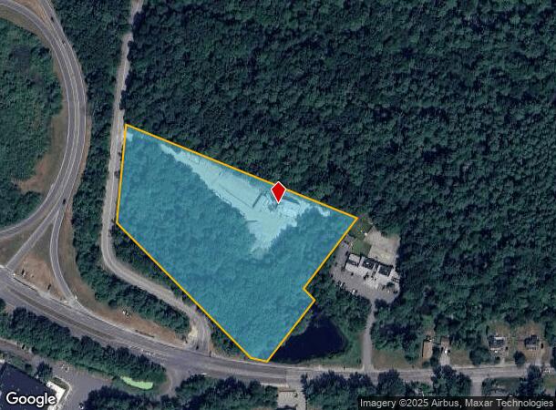
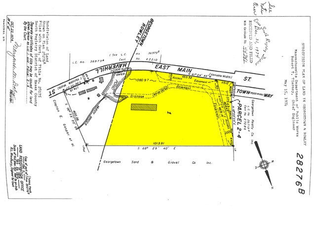
19 E National Ave
GEOR-000014-000000-000000-000006-000006
Essex
Manufacturinglight
Massachusetts
X
6
25009C0254G
13.88 AC
2025
Amesbury/Ipswich
2025
Boston
265102
Boston-Cambridge-Newton, MA-NH
2,730 SF
DEMOGRAPHICS near 19 E National Ave
1 Mile
3 Mile
5 Mile
2024 Total Population
1,685
15,602
36,656
2029 Population
1,682
15,553
36,503
Pop Growth 2024-2029
(0.18%)
(0.31%)
(0.42%)
Average Age
42
42
43
2024 Total Households
615
5,633
13,139
HH Growth 2024-2029
(0.33%)
(0.48%)
(0.59%)
Median Household Inc
$136,764
$139,833
$145,405
Avg Household Size
2.70
2.70
2.80
2024 Avg HH Vehicles
2.00
2.00
2.00
Median Home Value
$680,027
$654,310
$670,317
Median Year Built
1988
1977
1975
Nearby Places
Map Layers
Map Styles
 Street
 Aerial
- Restaurants
- Banks
- Shops
- Fitness
- Groceries
PUBLIC TRANSPORTATION
COMMUTER RAIL
Rowley (Newburyport/Rockport Line - Massachusetts Bay Transportation Authority Commuter Rail (Purple Line))
DRIVE
WALK
Distance
Rowley (Newburyport/Rockport Line - Massachusetts Bay Transportation Authority Commuter Rail (Purple Line))
15 min
6.3 mi
Ipswich (Newburyport/Rockport Line - Massachusetts Bay Transportation Authority Commuter Rail (Purple Line))
DRIVE
WALK
Distance
Ipswich (Newburyport/Rockport Line - Massachusetts Bay Transportation Authority Commuter Rail (Purple Line))
18 min
8.2 mi
AIRPORT
General Edward Lawrence Logan International
DRIVE
WALK
Distance
General Edward Lawrence Logan International
42 min
27.9 mi
Portsmouth International at Pease
DRIVE
WALK
Distance
Portsmouth International at Pease
39 min
29.2 mi
Manchester Boston Regional
DRIVE
WALK
Distance
Manchester Boston Regional
65 min
40.3 mi
Freight Ports
Port of Boston
DRIVE
WALK
Distance
Port of Boston
45 min
30.9 mi
Nearby Properties
Address
Land Use
TOTAL SIZE
Lot Size
Zoning
Address
Land Use
TOTAL SIZE
Lot Size
Zoning
Address
Land Use
TOTAL SIZE
Lot Size
Zoning
140,624 SF
26.21 AC
Address
Land Use
TOTAL SIZE
Lot Size
Zoning
86,812 SF
27.80 AC
Address
Land Use
TOTAL SIZE
Lot Size
Zoning
385,746 SF
7.79 AC
Address
Land Use
TOTAL SIZE
Lot Size
Zoning
64,162 SF
47.95 AC
Address
Land Use
TOTAL SIZE
Lot Size
Zoning
4,818 SF
12.90 AC
Address
Land Use
TOTAL SIZE
Lot Size
Zoning
106,342 SF
22.38 AC
Address
Land Use
TOTAL SIZE
Lot Size
Zoning
2,394 SF
63.04 AC
Address
Land Use
TOTAL SIZE
Lot Size
Zoning
130,204 SF
40.90 AC
Address
Land Use
TOTAL SIZE
Lot Size
Zoning
55,946 SF
20.50 AC
Address
Land Use
TOTAL SIZE
Lot Size
Zoning
108,934 SF
7.64 AC
LI
Address
Land Use
TOTAL SIZE
Lot Size
Zoning
159 AC
RRA
Address
Land Use
TOTAL SIZE
Lot Size
Zoning
8,649 SF
47 AC
Address
Land Use
TOTAL SIZE
Lot Size
Zoning
46,280 SF
7.80 AC
Address
Land Use
TOTAL SIZE
Lot Size
Zoning
65,044 SF
10.74 AC
Address
Land Use
TOTAL SIZE
Lot Size
Zoning
163.54 AC
Address
Land Use
TOTAL SIZE
Lot Size
Zoning
78,740 SF
14.54 AC
Address
Land Use
TOTAL SIZE
Lot Size
Zoning
53,709 SF
5.81 AC
Address
Land Use
TOTAL SIZE
Lot Size
Zoning
10,255 SF
6.39 AC
Address
Land Use
TOTAL SIZE
Lot Size
Zoning
118.81 AC
Address
Land Use
TOTAL SIZE
Lot Size
Zoning
14,240 SF
51.38 AC
PC
Address
Land Use
TOTAL SIZE
Lot Size
Zoning
3.70 AC
PC
Address
Land Use
TOTAL SIZE
Lot Size
Zoning
64,500 SF
6.93 AC
PC
Address
Land Use
TOTAL SIZE
Lot Size
Zoning
212.80 AC
RRA
Address
Land Use
TOTAL SIZE
Lot Size
Zoning
264 SF
232.27 AC
PC
Address
Land Use
TOTAL SIZE
Lot Size
Zoning
59,440 SF
8.65 AC
Address
Land Use
TOTAL SIZE
Lot Size
Zoning
21,245 SF
1.81 AC
Address
Land Use
TOTAL SIZE
Lot Size
Zoning
55.15 AC
Address
Land Use
TOTAL SIZE
Lot Size
Zoning
25,371 SF
3.54 AC
Address
Land Use
TOTAL SIZE
Lot Size
Zoning
57,400 SF
7.79 AC
LI
The World's #1 Commercial Real Estate Marketplace
Connect with us
© 2026 CoStar Group
The information above has been obtained from sources believed reliable. While we do not doubt its accuracy we have not verified it and make no guarantee, warranty or representation about it. It is your responsibility to independently confirm its accuracy and completeness. Any projections, opinions, assumptions, or estimates used are for example only and do not represent the current or future performance of the property. The value of this transaction to you depends on tax and other factors which should be evaluated by your tax, financial, and legal advisors. You and your advisors should conduct a careful, independent investigation of the property to determine to your satisfaction the suitability of the property for your needs.