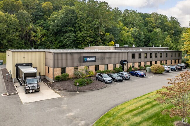
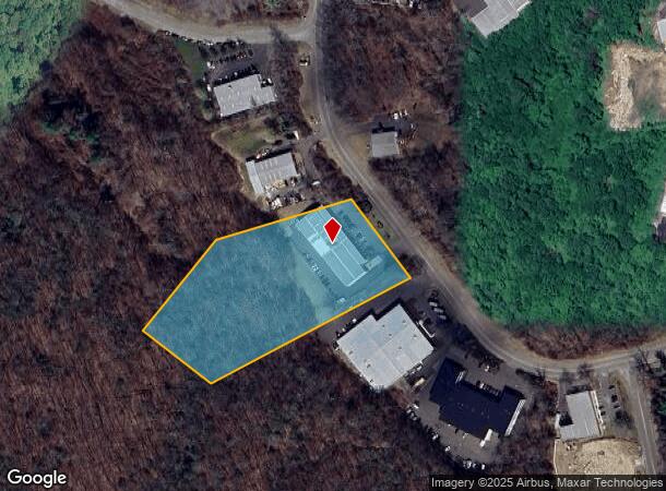
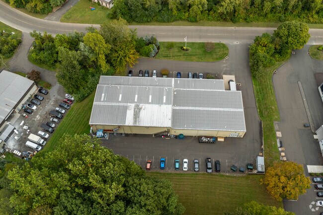
Property Record
19 Francis J Clarke Cir, Bethel, CT 06801
NEARBY LISTINGS FOR SALE OR LEASE
Property Detail
19 Francis J Clarke Cir
BETH-000010-000023-000150-000011
Fairfield
Warehouse
Connecticut
A
150
09001C0231F
4.21 AC
2024
Bethel
2025
Westchester/So Connecticut
200100
Bridgeport-Stamford-Norwalk, CT
24,094 SF
DEMOGRAPHICS near 19 Francis J Clarke Cir
1 Mile
3 Mile
5 Mile
2024 Total Population
2,369
38,888
97,809
2029 Population
2,358
38,618
97,317
Pop Growth 2024-2029
(0.46%)
(0.69%)
(0.50%)
Average Age
40
40
40
2024 Total Households
917
14,789
35,303
HH Growth 2024-2029
(0.44%)
(0.77%)
(0.61%)
Median Household Inc
$90,652
$70,824
$82,837
Avg Household Size
2.60
2.60
2.60
2024 Avg HH Vehicles
2.00
2.00
2.00
Median Home Value
$359,708
$348,635
$371,988
Median Year Built
1959
1969
1971
Nearby Places
Map Layers
Map Styles
 Street
 Aerial
- Restaurants
- Banks
- Shops
- Fitness
- Groceries
PUBLIC TRANSPORTATION
COMMUTER RAIL
Bethel Station (New Haven Line - Metro-North Commuter Railroad Company (Metro-North))
DRIVE
WALK
Distance
Bethel Station (New Haven Line - Metro-North Commuter Railroad Company (Metro-North))
7 min
2.5 mi
Redding Station (New Haven Line - Metro-North Commuter Railroad Company (Metro-North))
DRIVE
WALK
Distance
Redding Station (New Haven Line - Metro-North Commuter Railroad Company (Metro-North))
9 min
3.7 mi
AIRPORT
Westchester County
DRIVE
WALK
Distance
Westchester County
53 min
38.0 mi
Tweed/New Haven
DRIVE
WALK
Distance
Tweed/New Haven
65 min
39.3 mi
Freight Ports
Port of New Haven
DRIVE
WALK
Distance
Port of New Haven
60 min
36.4 mi
Nearby Properties
Address
Land Use
TOTAL SIZE
Lot Size
Zoning
Address
Land Use
TOTAL SIZE
Lot Size
Zoning
135.19 AC
IL40
Address
Land Use
TOTAL SIZE
Lot Size
Zoning
86,646 SF
122.26 AC
R-40
Address
Land Use
TOTAL SIZE
Lot Size
Zoning
478,816 SF
39.59 AC
IL40
Address
Land Use
TOTAL SIZE
Lot Size
Zoning
137,884 SF
16.96 AC
1L40
Address
Land Use
TOTAL SIZE
Lot Size
Zoning
158,981 SF
12.79 AC
RA20
Address
Land Use
TOTAL SIZE
Lot Size
Zoning
45.78 AC
RM12
Address
Land Use
TOTAL SIZE
Lot Size
Zoning
10 AC
CG-20
Address
Land Use
TOTAL SIZE
Lot Size
Zoning
17.24 AC
IL-40
Address
Land Use
TOTAL SIZE
Lot Size
Zoning
10.51 AC
IL40
Address
Land Use
TOTAL SIZE
Lot Size
Zoning
12.51 AC
IL40
Address
Land Use
TOTAL SIZE
Lot Size
Zoning
24.50 AC
RA8
Address
Land Use
TOTAL SIZE
Lot Size
Zoning
5.12 AC
CLCB
Address
Land Use
TOTAL SIZE
Lot Size
Zoning
304,561 SF
5.02 AC
IL40
Address
Land Use
TOTAL SIZE
Lot Size
Zoning
8,756 SF
8.10 AC
IL40
Address
Land Use
TOTAL SIZE
Lot Size
Zoning
56,658 SF
12 AC
RA40
Address
Land Use
TOTAL SIZE
Lot Size
Zoning
89,646 SF
1.35 AC
CLCB
Address
Land Use
TOTAL SIZE
Lot Size
Zoning
147.89 AC
IG-80
Address
Land Use
TOTAL SIZE
Lot Size
Zoning
19.10 AC
IL40
Address
Land Use
TOTAL SIZE
Lot Size
Zoning
64,285 SF
10.12 AC
RMF-4
Address
Land Use
TOTAL SIZE
Lot Size
Zoning
17.15 AC
IL40
Address
Land Use
TOTAL SIZE
Lot Size
Zoning
54,072 SF
2.06 AC
RH3
Address
Land Use
TOTAL SIZE
Lot Size
Zoning
283,933 SF
2.33 AC
CG20
Address
Land Use
TOTAL SIZE
Lot Size
Zoning
40,960 SF
0.78 AC
CLCB
Address
Land Use
TOTAL SIZE
Lot Size
Zoning
3.93 AC
CLCB
Address
Land Use
TOTAL SIZE
Lot Size
Zoning
3.84 AC
CG20
Address
Land Use
TOTAL SIZE
Lot Size
Zoning
71,713 SF
2.14 AC
RH3
Address
Land Use
TOTAL SIZE
Lot Size
Zoning
1.80 AC
CLCB
Address
Land Use
TOTAL SIZE
Lot Size
Zoning
36,291 SF
2.51 AC
VC
Address
Land Use
TOTAL SIZE
Lot Size
Zoning
7.88 AC
CG20
Address
Land Use
TOTAL SIZE
Lot Size
Zoning
61,603 SF
13.83 AC
R-40
The World's #1 Commercial Real Estate Marketplace
Connect with us
© 2025 CoStar Group
The information above has been obtained from sources believed reliable. While we do not doubt its accuracy we have not verified it and make no guarantee, warranty or representation about it. It is your responsibility to independently confirm its accuracy and completeness. Any projections, opinions, assumptions, or estimates used are for example only and do not represent the current or future performance of the property. The value of this transaction to you depends on tax and other factors which should be evaluated by your tax, financial, and legal advisors. You and your advisors should conduct a careful, independent investigation of the property to determine to your satisfaction the suitability of the property for your needs.