Property Record
19 Gilbert Ave, Smithtown, NY 11787


Save to a Folder
{{folder.Name}}
{{folder.ListingIds.length}} Properties
{{folder.ListingIds.length}} Property
Create a New Folder
Property Detail
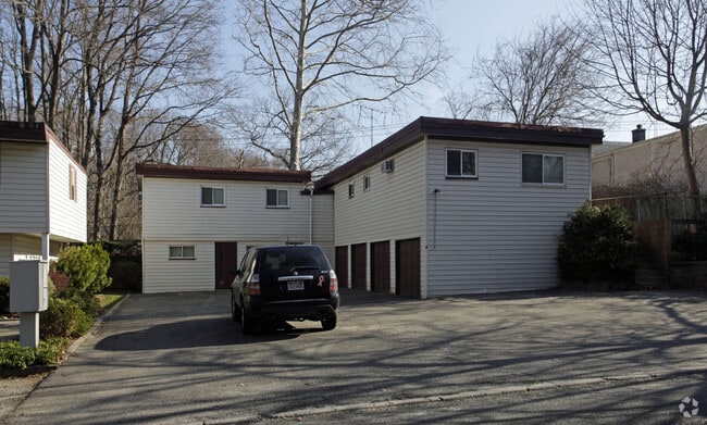
19 Gilbert Ave
Nassau County-Suffolk County, NY
18-713576 TC-70 *1397 LOTS-8-17 INC P/SMITHTOWN HOMESITES
0800-135-00-04-00-003-000
SUFFOLK
Apartment
New York
B and X Area of moderate flood hazard, usually the area between the limits of the 100-year and 500-year floods.
3
2024
0.53 AC
2025
Nesconset
134909
Long Island (New York)
NEARBY LISTINGS FOR SALE OR LEASE
-
-
View all Smithtown listings for sale on LoopNet.com
DEMOGRAPHICS near 19 Gilbert Ave
1 mile
3 mile
5 mile
2025 Total Population
10,649
78,456
210,045
2030 Population
10,580
78,158
208,382
Pop Growth 2025-2030
(0.65%)
(0.38%)
(0.79%)
Average Age
43
42
41
2025 Total Households
3,675
26,476
67,528
HH Growth 2025-2030
(0.95%)
(0.65%)
(0.96%)
Median Household Inc
$134,895
$134,870
$130,022
Avg Household Size
2.80
2.90
3.00
2025 Avg HH Vehicles
2.00
2.00
2.00
Median Home Value
$717,689
$678,692
$633,984
Median Year Built
1971
1968
1968
Nearby Places
Map Layers
Map Styles
 Street
 Aerial
Layers
 Traffic
 Biking
Places
Listings with unknown addresses are not visible on the map
- Restaurants
- Banks
- Shops
- Fitness
- Groceries
PUBLIC TRANSPORTATION
COMMUTER RAIL
Smithtown Station (Port Jefferson Branch - Long Island Rail Road)
Drive
Walk
Distance
Smithtown Station (Port Jefferson Branch - Long Island Rail Road)
6 min
2.7 mi
St James Station (Port Jefferson Branch - Long Island Rail Road)
Drive
Walk
Distance
St James Station (Port Jefferson Branch - Long Island Rail Road)
8 min
3.6 mi
AIRPORT
Long Island MacArthur
Drive
Walk
Distance
Long Island MacArthur
15 min
6.6 mi
Nearby Properties
Address
Land Use
TOTAL SIZE
Lot Size
Zoning
Address
Land Use
TOTAL SIZE
Lot Size
Zoning
57.30 AC
AAA
Address
Land Use
TOTAL SIZE
Lot Size
Zoning
8.18 AC
NULL
Address
Land Use
TOTAL SIZE
Lot Size
Zoning
2.79 AC
Address
Land Use
TOTAL SIZE
Lot Size
Zoning
36.66 AC
NULL
Address
Land Use
TOTAL SIZE
Lot Size
Zoning
24.96 AC
Address
Land Use
TOTAL SIZE
Lot Size
Zoning
5.32 AC
BUS3
Address
Land Use
TOTAL SIZE
Lot Size
Zoning
24.70 AC
AAA
Address
Land Use
TOTAL SIZE
Lot Size
Zoning
13.06 AC
BUS3
Address
Land Use
TOTAL SIZE
Lot Size
Zoning
15 AC
AA
Address
Land Use
TOTAL SIZE
Lot Size
Zoning
12.84 AC
NULL
Address
Land Use
TOTAL SIZE
Lot Size
Zoning
23.08 AC
AA
Address
Land Use
TOTAL SIZE
Lot Size
Zoning
8.02 AC
NULL
Address
Land Use
TOTAL SIZE
Lot Size
Zoning
10.50 AC
NULL
Address
Land Use
TOTAL SIZE
Lot Size
Zoning
45.71 AC
NULL
Address
Land Use
TOTAL SIZE
Lot Size
Zoning
6.81 AC
NULL
Address
Land Use
TOTAL SIZE
Lot Size
Zoning
12.80 AC
AAA
Address
Land Use
TOTAL SIZE
Lot Size
Zoning
8.35 AC
IND1
Address
Land Use
TOTAL SIZE
Lot Size
Zoning
9.90 AC
CA
Address
Land Use
TOTAL SIZE
Lot Size
Zoning
10.30 AC
CA
Address
Land Use
TOTAL SIZE
Lot Size
Zoning
6.60 AC
CA
Address
Land Use
TOTAL SIZE
Lot Size
Zoning
6.48 AC
CA
Address
Land Use
TOTAL SIZE
Lot Size
Zoning
11.86 AC
NULL
Address
Land Use
TOTAL SIZE
Lot Size
Zoning
4.52 AC
CA
Address
Land Use
TOTAL SIZE
Lot Size
Zoning
7.54 AC
Address
Land Use
TOTAL SIZE
Lot Size
Zoning
60.30 AC
Address
Land Use
TOTAL SIZE
Lot Size
Zoning
4.60 AC
GSE
Address
Land Use
TOTAL SIZE
Lot Size
Zoning
6.23 AC
NULL
Address
Land Use
TOTAL SIZE
Lot Size
Zoning
0.28 AC
VILLA
Address
Land Use
TOTAL SIZE
Lot Size
Zoning
35.62 AC
NULL
Address
Land Use
TOTAL SIZE
Lot Size
Zoning
4.91 AC
AAA
The World's #1 Commercial Real Estate Marketplace
Connect with us
© 2026 CoStar Group
The information above has been obtained from sources believed reliable. While we do not doubt its accuracy we have not verified it and make no guarantee, warranty or representation about it. It is your responsibility to independently confirm its accuracy and completeness. Any projections, opinions, assumptions, or estimates used are for example only and do not represent the current or future performance of the property. The value of this transaction to you depends on tax and other factors which should be evaluated by your tax, financial, and legal advisors. You and your advisors should conduct a careful, independent investigation of the property to determine to your satisfaction the suitability of the property for your needs.