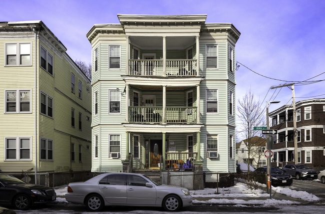
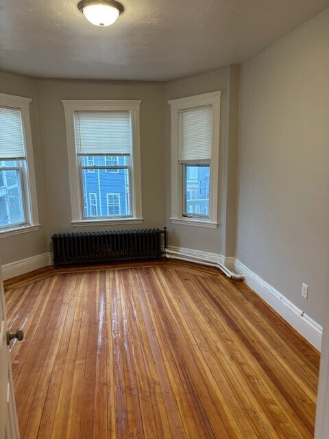
Property Record
19 Irma St, Dorchester Center, MA 02124

NEARBY LISTINGS FOR SALE OR LEASE
Property Detail
19 Irma St
Boston-Cambridge-Newton, MA-NH
Dorchester
DORC-000000-000014-003231
Suffolk
Triplex
Massachusetts
X
0.10 AC
25025C0087G
Franklin Field South
4,440 SF
Boston
DEMOGRAPHICS near 19 Irma St
1 Mile
3 Mile
5 Mile
2024 Total Population
41,897
277,365
686,701
2029 Population
40,069
266,594
672,899
Pop Growth 2024-2029
(4.36%)
(3.88%)
(2.01%)
Average Age
38
40
39
2024 Total Households
13,950
102,848
276,101
HH Growth 2024-2029
(5.28%)
(4.63%)
(2.40%)
Median Household Inc
$65,846
$92,111
$102,397
Avg Household Size
2.80
2.50
2.20
2024 Avg HH Vehicles
1.00
1.00
1.00
Median Home Value
$619,543
$715,067
$796,589
Median Year Built
1948
1948
1950
Nearby Places
Map Layers
Map Styles
 Street
 Aerial
- Restaurants
- Banks
- Shops
- Fitness
- Groceries
PUBLIC TRANSPORTATION
COMMUTER RAIL
Morton Street (Fairmount Line - Massachusetts Bay Transportation Authority Commuter Rail (Purple Line))
DRIVE
WALK
Distance
Morton Street (Fairmount Line - Massachusetts Bay Transportation Authority Commuter Rail (Purple Line))
2 min
11 min
0.6 mi
DRIVE
WALK
Distance
3 min
18 min
0.9 mi
AIRPORT
General Edward Lawrence Logan International
DRIVE
WALK
Distance
General Edward Lawrence Logan International
16 min
8.4 mi
Freight Ports
Port of Boston
DRIVE
WALK
Distance
Port of Boston
13 min
6.3 mi
SALE & LEASE HISTORY
LISTING DATE
SALE/LEASE

Jun 17, 2025
For Sale
Nearby Properties
Address
Land Use
TOTAL SIZE
Lot Size
Zoning
Address
Land Use
TOTAL SIZE
Lot Size
Zoning
262,120 SF
0.62 AC
C
Address
Land Use
TOTAL SIZE
Lot Size
Zoning
303,055 SF
2.15 AC
RC
Address
Land Use
TOTAL SIZE
Lot Size
Zoning
251,272 SF
3.77 AC
BUSC
Address
Land Use
TOTAL SIZE
Lot Size
Zoning
146,751 SF
3.39 AC
E
Address
Land Use
TOTAL SIZE
Lot Size
Zoning
428,271 SF
9.65 AC
E
Address
Land Use
TOTAL SIZE
Lot Size
Zoning
45,000 SF
14.30 AC
E
Address
Land Use
TOTAL SIZE
Lot Size
Zoning
351,680 SF
4.01 AC
RC
Address
Land Use
TOTAL SIZE
Lot Size
Zoning
255,257 SF
2.34 AC
A
Address
Land Use
TOTAL SIZE
Lot Size
Zoning
1,940 SF
58.17 AC
E
Address
Land Use
TOTAL SIZE
Lot Size
Zoning
681,518 SF
34.52 AC
Address
Land Use
TOTAL SIZE
Lot Size
Zoning
240.18 AC
E
Address
Land Use
TOTAL SIZE
Lot Size
Zoning
291,918 SF
1.99 AC
RC
Address
Land Use
TOTAL SIZE
Lot Size
Zoning
332,366 SF
4.86 AC
E
Address
Land Use
TOTAL SIZE
Lot Size
Zoning
728,348 SF
11.71 AC
C
Address
Land Use
TOTAL SIZE
Lot Size
Zoning
273,051 SF
5.41 AC
E
Address
Land Use
TOTAL SIZE
Lot Size
Zoning
228,215 SF
2.44 AC
RC
Address
Land Use
TOTAL SIZE
Lot Size
Zoning
18,070 SF
119.45 AC
E
Address
Land Use
TOTAL SIZE
Lot Size
Zoning
526,040 SF
27.79 AC
E
Address
Land Use
TOTAL SIZE
Lot Size
Zoning
21,830 SF
158.48 AC
E
Address
Land Use
TOTAL SIZE
Lot Size
Zoning
137,800 SF
5.67 AC
E
Address
Land Use
TOTAL SIZE
Lot Size
Zoning
2,781 SF
60.98 AC
S40
Address
Land Use
TOTAL SIZE
Lot Size
Zoning
132,321 SF
3.94 AC
RC
Address
Land Use
TOTAL SIZE
Lot Size
Zoning
53.23 AC
E
Address
Land Use
TOTAL SIZE
Lot Size
Zoning
377,249 SF
2.81 AC
RC
Address
Land Use
TOTAL SIZE
Lot Size
Zoning
173,630 SF
4.46 AC
E
Address
Land Use
TOTAL SIZE
Lot Size
Zoning
17.85 AC
BUSC
Address
Land Use
TOTAL SIZE
Lot Size
Zoning
560,065 SF
28.20 AC
Address
Land Use
TOTAL SIZE
Lot Size
Zoning
217,302 SF
13.47 AC
RA
Address
Land Use
TOTAL SIZE
Lot Size
Zoning
221,500 SF
4.99 AC
E
Address
Land Use
TOTAL SIZE
Lot Size
Zoning
146,374 SF
2 AC
RC
The World's #1 Commercial Real Estate Marketplace
Connect with us
© 2026 CoStar Group
The information above has been obtained from sources believed reliable. While we do not doubt its accuracy we have not verified it and make no guarantee, warranty or representation about it. It is your responsibility to independently confirm its accuracy and completeness. Any projections, opinions, assumptions, or estimates used are for example only and do not represent the current or future performance of the property. The value of this transaction to you depends on tax and other factors which should be evaluated by your tax, financial, and legal advisors. You and your advisors should conduct a careful, independent investigation of the property to determine to your satisfaction the suitability of the property for your needs.