Property Record
19 Main St, Old Saybrook, CT 06475
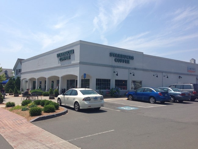

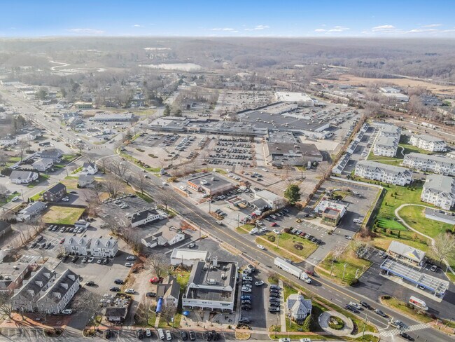
Property Detail
19 Main St
Commercialbuilding
Lower Ct River Vly
B-1
Connecticut
B and X Area of moderate flood hazard, usually the area between the limits of the 100-year and 500-year floods.
0.21 AC
2025
SW Midlsx/Old Saybrk/Rt 9
2025
Hartford
670200
Hartford-West Hartford-East Hartford, CT
6,660 SF
OSAY-000037-000051
NEARBY LISTINGS FOR SALE OR LEASE
DEMOGRAPHICS near 19 Main St
1 mile
3 mile
5 mile
2025 Total Population
2,746
14,815
27,540
2030 Population
2,812
15,439
28,564
Pop Growth 2025-2030
+ 2.40%
+ 4.21%
+ 3.72%
Average Age
50
50
50
2025 Total Households
1,246
6,641
12,271
HH Growth 2025-2030
+ 2.41%
+ 4.44%
+ 3.93%
Median Household Inc
$83,355
$117,530
$110,638
Avg Household Size
2.10
2.20
2.20
2025 Avg HH Vehicles
2.00
2.00
2.00
Median Home Value
$457,873
$576,523
$582,759
Median Year Built
1972
1970
1970
Nearby Places
Map Layers
Map Styles
 Street
 Aerial
Transit
 Traffic
 Biking
Places
Listings with unknown addresses are not visible on the map
- Restaurants
- Banks
- Shops
- Fitness
- Groceries
PUBLIC TRANSPORTATION
COMMUTER RAIL
Old Saybrook (Shore Line East - Shore Line East)
Drive
Walk
Distance
Old Saybrook (Shore Line East - Shore Line East)
3 min
14 min
0.8 mi
Westbrook (Shore Line East - Shore Line East)
Drive
Walk
Distance
Westbrook (Shore Line East - Shore Line East)
8 min
5.4 mi
Freight Ports
Port of Davisville, RI
Drive
Walk
Distance
Port of Davisville, RI
1 min
54.7 mi
SALE & LEASE HISTORY
LISTING DATE
SALE/LEASE

Sep 24, 2016
For Lease
May 22, 2018
For Lease
Mar 13, 2017
For Lease
Apr 21, 2021
For Sale
Nearby Properties
Address
Land Use
TOTAL SIZE
Lot Size
Zoning
Address
Land Use
TOTAL SIZE
Lot Size
Zoning
10.78 AC
B-2
Address
Land Use
TOTAL SIZE
Lot Size
Zoning
35.40 AC
B-2
Address
Land Use
TOTAL SIZE
Lot Size
Zoning
39.32 AC
LI/LDR
Address
Land Use
TOTAL SIZE
Lot Size
Zoning
40,942 SF
7.45 AC
A
Address
Land Use
TOTAL SIZE
Lot Size
Zoning
83,486 SF
3.71 AC
SP-2
Address
Land Use
TOTAL SIZE
Lot Size
Zoning
20.17 AC
A
Address
Land Use
TOTAL SIZE
Lot Size
Zoning
14.78 AC
B-4
Address
Land Use
TOTAL SIZE
Lot Size
Zoning
49.71 AC
TIC
Address
Land Use
TOTAL SIZE
Lot Size
Zoning
12.35 AC
C-30
Address
Land Use
TOTAL SIZE
Lot Size
Zoning
101,587 SF
34.34 AC
A
Address
Land Use
TOTAL SIZE
Lot Size
Zoning
10.36 AC
RU40
Address
Land Use
TOTAL SIZE
Lot Size
Zoning
14.25 AC
A
Address
Land Use
TOTAL SIZE
Lot Size
Zoning
80.46 AC
AA-2
Address
Land Use
TOTAL SIZE
Lot Size
Zoning
72,128 SF
22.08 AC
I-1
Address
Land Use
TOTAL SIZE
Lot Size
Zoning
10.80 AC
I-1
Address
Land Use
TOTAL SIZE
Lot Size
Zoning
17,833 SF
3.87 AC
A
Address
Land Use
TOTAL SIZE
Lot Size
Zoning
7.36 AC
B1
Address
Land Use
TOTAL SIZE
Lot Size
Zoning
25,144 SF
3.74 AC
B-4
Address
Land Use
TOTAL SIZE
Lot Size
Zoning
24,360 SF
7.78 AC
B-2
Address
Land Use
TOTAL SIZE
Lot Size
Zoning
64,427 SF
1.46 AC
Address
Land Use
TOTAL SIZE
Lot Size
Zoning
291,816 SF
29.64 AC
I-1
Address
Land Use
TOTAL SIZE
Lot Size
Zoning
52,960 SF
32 AC
AA1
Address
Land Use
TOTAL SIZE
Lot Size
Zoning
55,250 SF
4.41 AC
B-4
Address
Land Use
TOTAL SIZE
Lot Size
Zoning
1.58 AC
SP3
Address
Land Use
TOTAL SIZE
Lot Size
Zoning
2.51 AC
AA-2
Address
Land Use
TOTAL SIZE
Lot Size
Zoning
5.10 AC
AA-3
Address
Land Use
TOTAL SIZE
Lot Size
Zoning
8.44 AC
B-2
Address
Land Use
TOTAL SIZE
Lot Size
Zoning
22,970 SF
1.25 AC
A
Address
Land Use
TOTAL SIZE
Lot Size
Zoning
12.25 AC
MC
Address
Land Use
TOTAL SIZE
Lot Size
Zoning
6.35 AC
The World's #1 Commercial Real Estate Marketplace
Connect with us
© 2026 CoStar Group
The information above has been obtained from sources believed reliable. While we do not doubt its accuracy we have not verified it and make no guarantee, warranty or representation about it. It is your responsibility to independently confirm its accuracy and completeness. Any projections, opinions, assumptions, or estimates used are for example only and do not represent the current or future performance of the property. The value of this transaction to you depends on tax and other factors which should be evaluated by your tax, financial, and legal advisors. You and your advisors should conduct a careful, independent investigation of the property to determine to your satisfaction the suitability of the property for your needs.