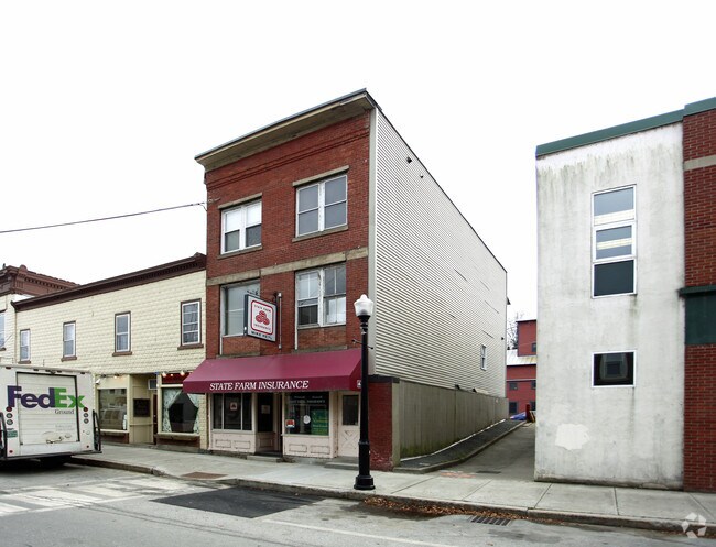
Property Record
19 Merchants Row, Randolph, VT 05060
Save to a Folder
{{folder.Name}}
{{folder.ListingIds.length}} Properties
{{folder.ListingIds.length}} Property
Create a New Folder
Property Detail
19 Merchants Row
Lebanon-Claremont, NH-VT
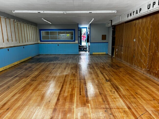
0.02 ACRES & COMM BLOCK / 2 APTS
507-159-13608
Orange
Apartment
Vermont
2024
0.02 AC
2025
Vermont North Area
959400
Other Market Areas
NEARBY LISTINGS FOR SALE OR LEASE
DEMOGRAPHICS near 19 Merchants Row
1 mile
3 mile
5 mile
2025 Total Population
2,147
3,628
5,554
2030 Population
2,194
3,720
5,683
Pop Growth 2025-2030
+ 2.19%
+ 2.54%
+ 2.32%
Average Age
45
46
45
2025 Total Households
962
1,598
2,344
HH Growth 2025-2030
+ 2.29%
+ 2.63%
+ 2.43%
Median Household Inc
$59,240
$66,022
$71,412
Avg Household Size
2.20
2.20
2.30
2025 Avg HH Vehicles
2.00
2.00
2.00
Median Home Value
$281,221
$282,370
$290,475
Median Year Built
1948
1964
1971
Nearby Places
Map Layers
Map Styles
 Street
 Aerial
Layers
 Traffic
 Biking
Places
Listings with unknown addresses are not visible on the map
- Restaurants
- Banks
- Shops
- Fitness
- Groceries
PUBLIC TRANSPORTATION
COMMUTER RAIL
Drive
Walk
Distance
1 min
2 min
0.1 mi
SALE & LEASE HISTORY
LISTING DATE
SALE/LEASE

Aug 12, 2024
For Lease
Nearby Properties
Address
Land Use
TOTAL SIZE
Lot Size
Zoning
Address
Land Use
TOTAL SIZE
Lot Size
Zoning
31.70 AC
Address
Land Use
TOTAL SIZE
Lot Size
Zoning
95,554 SF
6.20 AC
Address
Land Use
TOTAL SIZE
Lot Size
Zoning
11.50 AC
Address
Land Use
TOTAL SIZE
Lot Size
Zoning
62,664 SF
13.72 AC
C
Address
Land Use
TOTAL SIZE
Lot Size
Zoning
29,556 SF
24.70 AC
M
Address
Land Use
TOTAL SIZE
Lot Size
Zoning
60,736 SF
42.10 AC
I
Address
Land Use
TOTAL SIZE
Lot Size
Zoning
550.48 AC
C
Address
Land Use
TOTAL SIZE
Lot Size
Zoning
6.90 AC
C
Address
Land Use
TOTAL SIZE
Lot Size
Zoning
66,270 SF
12.18 AC
I
Address
Land Use
TOTAL SIZE
Lot Size
Zoning
40,988 SF
7.60 AC
I
Address
Land Use
TOTAL SIZE
Lot Size
Zoning
23,248 SF
1.14 AC
C
Address
Land Use
TOTAL SIZE
Lot Size
Zoning
72,512 SF
32.23 AC
I
Address
Land Use
TOTAL SIZE
Lot Size
Zoning
15,875 SF
0.47 AC
Address
Land Use
TOTAL SIZE
Lot Size
Zoning
79,433 SF
71.40 AC
I
Address
Land Use
TOTAL SIZE
Lot Size
Zoning
550.48 AC
Address
Land Use
TOTAL SIZE
Lot Size
Zoning
23,290 SF
7.34 AC
I
Address
Land Use
TOTAL SIZE
Lot Size
Zoning
15.50 AC
Address
Land Use
TOTAL SIZE
Lot Size
Zoning
6,264 SF
1.41 AC
C
Address
Land Use
TOTAL SIZE
Lot Size
Zoning
10,526 SF
5.70 AC
Address
Land Use
TOTAL SIZE
Lot Size
Zoning
114,878 SF
7.80 AC
I
Address
Land Use
TOTAL SIZE
Lot Size
Zoning
16,828 SF
0.50 AC
Address
Land Use
TOTAL SIZE
Lot Size
Zoning
42.10 AC
Address
Land Use
TOTAL SIZE
Lot Size
Zoning
9.01 AC
C
Address
Land Use
TOTAL SIZE
Lot Size
Zoning
3,711 SF
5.66 AC
C
Address
Land Use
TOTAL SIZE
Lot Size
Zoning
14,319 SF
5.38 AC
C
Address
Land Use
TOTAL SIZE
Lot Size
Zoning
4,278 SF
1.03 AC
C
Address
Land Use
TOTAL SIZE
Lot Size
Zoning
12,157 SF
2.60 AC
Address
Land Use
TOTAL SIZE
Lot Size
Zoning
15,324 SF
0.14 AC
C
Address
Land Use
TOTAL SIZE
Lot Size
Zoning
10,085 SF
0.55 AC
C
Address
Land Use
TOTAL SIZE
Lot Size
Zoning
15,536 SF
1.45 AC
C
The World's #1 Commercial Real Estate Marketplace
Connect with us
© 2026 CoStar Group
The information above has been obtained from sources believed reliable. While we do not doubt its accuracy we have not verified it and make no guarantee, warranty or representation about it. It is your responsibility to independently confirm its accuracy and completeness. Any projections, opinions, assumptions, or estimates used are for example only and do not represent the current or future performance of the property. The value of this transaction to you depends on tax and other factors which should be evaluated by your tax, financial, and legal advisors. You and your advisors should conduct a careful, independent investigation of the property to determine to your satisfaction the suitability of the property for your needs.