Property Record
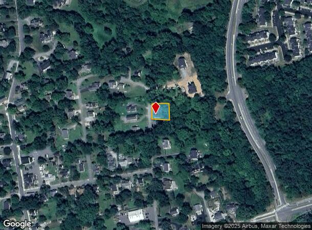
19 N Bridge St, Round Hill, VA 20141
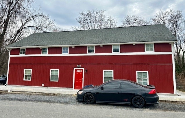
This Property Is For Sale
NEARBY LISTINGS FOR SALE OR LEASE
-
-
View all Round Hill listings for sale on LoopNet.com
Property Detail
19 N Bridge St
555-25-1384
Round Hill
Multifamilydwelling
TOWN OF ROUND HILL 200804010018944 596-693
X
Loudoun
54037C0245E
Virginia
2025
0.22 AC
2025
Outer Greenway-Dulles
610202
Washington, DC
3,976 SF
Washington-Arlington-Alexandria, DC-VA-MD-WV
DEMOGRAPHICS near 19 N Bridge St
1 Mile
3 Mile
5 Mile
2024 Total Population
5,248
14,959
25,400
2029 Population
5,574
15,980
27,126
Pop Growth 2024-2029
+ 6.21%
+ 6.83%
+ 6.80%
Average Age
37
38
39
2024 Total Households
1,568
4,618
8,013
HH Growth 2024-2029
+ 6.25%
+ 6.93%
+ 6.90%
Median Household Inc
$171,192
$176,265
$166,851
Avg Household Size
3.30
3.20
3.10
2024 Avg HH Vehicles
3.00
3.00
3.00
Median Home Value
$616,384
$695,914
$705,652
Median Year Built
1999
1999
1996
Nearby Places
Map Layers
Map Styles
 Street
 Aerial
- Restaurants
- Banks
- Shops
- Fitness
- Groceries
PUBLIC TRANSPORTATION
AIRPORT
Washington Dulles International
DRIVE
WALK
Distance
Washington Dulles International
44 min
29.0 mi
Nearby Properties
Address
Land Use
TOTAL SIZE
Lot Size
Zoning
Address
Land Use
TOTAL SIZE
Lot Size
Zoning
347,910 SF
209.21 AC
PV:X
Address
Land Use
TOTAL SIZE
Lot Size
Zoning
5,168 SF
199.35 AC
AR1
Address
Land Use
TOTAL SIZE
Lot Size
Zoning
77,439 SF
20 AC
PDH3
Address
Land Use
TOTAL SIZE
Lot Size
Zoning
4,000 SF
21.02 AC
AR1
Address
Land Use
TOTAL SIZE
Lot Size
Zoning
52,400 SF
11.69 AC
PV:IP
Address
Land Use
TOTAL SIZE
Lot Size
Zoning
46,584 SF
2.62 AC
PV:C1
Address
Land Use
TOTAL SIZE
Lot Size
Zoning
29,884 SF
7.31 AC
PV:IP
Address
Land Use
TOTAL SIZE
Lot Size
Zoning
12,000 SF
15.89 AC
PV:IP
Address
Land Use
TOTAL SIZE
Lot Size
Zoning
18,860 SF
2.17 AC
PV:IP
Address
Land Use
TOTAL SIZE
Lot Size
Zoning
8,775 SF
14.18 AC
TO
Address
Land Use
TOTAL SIZE
Lot Size
Zoning
21,027 SF
3.06 AC
PV:IP
Address
Land Use
TOTAL SIZE
Lot Size
Zoning
28,440 SF
1.68 AC
PV:CM1
Address
Land Use
TOTAL SIZE
Lot Size
Zoning
25,400 SF
2.47 AC
PV:CM1
Address
Land Use
TOTAL SIZE
Lot Size
Zoning
9,048 SF
30.15 AC
PDH3
Address
Land Use
TOTAL SIZE
Lot Size
Zoning
28,000 SF
2.43 AC
PV:X
Address
Land Use
TOTAL SIZE
Lot Size
Zoning
22,953 SF
3.63 AC
PV:CM1
Address
Land Use
TOTAL SIZE
Lot Size
Zoning
102.77 AC
RH:R2
Address
Land Use
TOTAL SIZE
Lot Size
Zoning
12,608 SF
2.36 AC
PV:CM1
Address
Land Use
TOTAL SIZE
Lot Size
Zoning
27,000 SF
1.86 AC
PV:M1
Address
Land Use
TOTAL SIZE
Lot Size
Zoning
34,975 SF
3.94 AC
PV:CM1
Address
Land Use
TOTAL SIZE
Lot Size
Zoning
20,670 SF
0.99 AC
PV:CM1
Address
Land Use
TOTAL SIZE
Lot Size
Zoning
25,338 SF
9.85 AC
JLMA1
Address
Land Use
TOTAL SIZE
Lot Size
Zoning
44,176 SF
4 AC
PV:R15
Address
Land Use
TOTAL SIZE
Lot Size
Zoning
11,978 SF
0.55 AC
PV:C4
Address
Land Use
TOTAL SIZE
Lot Size
Zoning
18,780 SF
2.90 AC
PV:C4
Address
Land Use
TOTAL SIZE
Lot Size
Zoning
27,685 SF
3.52 AC
PV:C4
Address
Land Use
TOTAL SIZE
Lot Size
Zoning
23,207 SF
1.62 AC
PV:CM1
Address
Land Use
TOTAL SIZE
Lot Size
Zoning
11,624 SF
1.87 AC
PV:IP
Address
Land Use
TOTAL SIZE
Lot Size
Zoning
14,540 SF
4.96 AC
PV:IP
Address
Land Use
TOTAL SIZE
Lot Size
Zoning
22,818 SF
3.16 AC
JLMA1
The World's #1 Commercial Real Estate Marketplace
Connect with us
© 2025 CoStar Group
The information above has been obtained from sources believed reliable. While we do not doubt its accuracy we have not verified it and make no guarantee, warranty or representation about it. It is your responsibility to independently confirm its accuracy and completeness. Any projections, opinions, assumptions, or estimates used are for example only and do not represent the current or future performance of the property. The value of this transaction to you depends on tax and other factors which should be evaluated by your tax, financial, and legal advisors. You and your advisors should conduct a careful, independent investigation of the property to determine to your satisfaction the suitability of the property for your needs.