Property Record
19 Navajo Trail Dr, Pagosa Springs, CO 81147

NEARBY LISTINGS FOR SALE OR LEASE
Property Detail
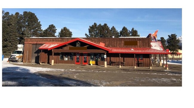
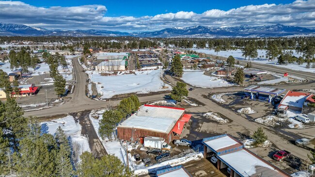
19 Navajo Trail Dr
569920105014
Pag Vill Serv Comm
Restaurantbuilding
SUBDIVISION: PAG VILL SERV COMM LOT: 29 P VIL SER SEC: 20 TWN: 35 RNG: 2W
X
Archuleta
08007C0265D
Colorado
2024
29
2024
0.60 AC
974202
Colorado Southwest Area
4,620 SF
Other Market Areas
DEMOGRAPHICS near 19 Navajo Trail Dr
1 Mile
3 Mile
5 Mile
2024 Total Population
2,036
7,285
9,849
2029 Population
2,347
8,322
11,214
Pop Growth 2024-2029
+ 15.28%
+ 14.23%
+ 13.86%
Average Age
46
46
46
2024 Total Households
908
3,179
4,250
HH Growth 2024-2029
+ 15.75%
+ 14.56%
+ 14.14%
Median Household Inc
$59,166
$64,368
$63,608
Avg Household Size
2.20
2.20
2.30
2024 Avg HH Vehicles
2.00
2.00
2.00
Median Home Value
$354,878
$399,999
$410,653
Median Year Built
1994
1995
1995
Nearby Places
Map Layers
Map Styles
 Street
 Aerial
- Restaurants
- Banks
- Shops
- Fitness
- Groceries
SALE & LEASE HISTORY
LISTING DATE
SALE/LEASE

Mar 02, 2023
For Sale
Jan 27, 2020
For Sale
Nearby Properties
Address
Land Use
TOTAL SIZE
Lot Size
Zoning
Address
Land Use
TOTAL SIZE
Lot Size
Zoning
35,811 SF
3 AC
MIXED-USE
Address
Land Use
TOTAL SIZE
Lot Size
Zoning
47,570 SF
6.97 AC
PUBLIC/QUA
Address
Land Use
TOTAL SIZE
Lot Size
Zoning
38,414 SF
13.63 AC
MIXED-USE
Address
Land Use
TOTAL SIZE
Lot Size
Zoning
15,960 SF
362.64 AC
INDUSTRIAL
Address
Land Use
TOTAL SIZE
Lot Size
Zoning
11,010 SF
14.53 AC
PUBLIC/QUA
Address
Land Use
TOTAL SIZE
Lot Size
Zoning
2,690 SF
4.98 AC
MIXED-USE
Address
Land Use
TOTAL SIZE
Lot Size
Zoning
10.61 AC
MIXED-USE
Address
Land Use
TOTAL SIZE
Lot Size
Zoning
2.62 AC
COMMERCIAL
Address
Land Use
TOTAL SIZE
Lot Size
Zoning
2,176 SF
38.13 AC
AGRICULTUR
Address
Land Use
TOTAL SIZE
Lot Size
Zoning
MIXED-USE
Address
Land Use
TOTAL SIZE
Lot Size
Zoning
27,645 SF
5.03 AC
MIXED-USE
Address
Land Use
TOTAL SIZE
Lot Size
Zoning
5,729 SF
2.25 AC
COMMERCIAL
Address
Land Use
TOTAL SIZE
Lot Size
Zoning
19,764 SF
2.16 AC
PLANNED UN
Address
Land Use
TOTAL SIZE
Lot Size
Zoning
8,600 SF
30.20 AC
PLANNED UN
Address
Land Use
TOTAL SIZE
Lot Size
Zoning
8,228 SF
3.29 AC
PUBLIC/QUA
Address
Land Use
TOTAL SIZE
Lot Size
Zoning
6,840 SF
3.99 AC
PUBLIC/QUA
Address
Land Use
TOTAL SIZE
Lot Size
Zoning
11,282 SF
5.69 AC
AGRICULTUR
Address
Land Use
TOTAL SIZE
Lot Size
Zoning
13,024 SF
2.88 AC
COMMERCIAL
Address
Land Use
TOTAL SIZE
Lot Size
Zoning
0.63 AC
PLANNED UN
Address
Land Use
TOTAL SIZE
Lot Size
Zoning
37,750 SF
4.52 AC
PLANNED UN
Address
Land Use
TOTAL SIZE
Lot Size
Zoning
4,917 SF
20.03 AC
PLANNED UN
Address
Land Use
TOTAL SIZE
Lot Size
Zoning
18,693 SF
1.36 AC
MIXED-USE
Address
Land Use
TOTAL SIZE
Lot Size
Zoning
8,573 SF
6.44 AC
PLANNED UN
Address
Land Use
TOTAL SIZE
Lot Size
Zoning
1.37 AC
MIXED-USE
Address
Land Use
TOTAL SIZE
Lot Size
Zoning
22,540 SF
4.78 AC
MIXED-USE
Address
Land Use
TOTAL SIZE
Lot Size
Zoning
3,648 SF
0.80 AC
PLANNED UN
Address
Land Use
TOTAL SIZE
Lot Size
Zoning
16,000 SF
6 AC
MIXED-USE
Address
Land Use
TOTAL SIZE
Lot Size
Zoning
13,601 SF
2.53 AC
COMMERCIAL
Address
Land Use
TOTAL SIZE
Lot Size
Zoning
4,444 SF
7.18 AC
PUBLIC/QUA
Address
Land Use
TOTAL SIZE
Lot Size
Zoning
7,998 SF
1.07 AC
PLANNED UN
The World's #1 Commercial Real Estate Marketplace
Connect with us
© 2026 CoStar Group
The information above has been obtained from sources believed reliable. While we do not doubt its accuracy we have not verified it and make no guarantee, warranty or representation about it. It is your responsibility to independently confirm its accuracy and completeness. Any projections, opinions, assumptions, or estimates used are for example only and do not represent the current or future performance of the property. The value of this transaction to you depends on tax and other factors which should be evaluated by your tax, financial, and legal advisors. You and your advisors should conduct a careful, independent investigation of the property to determine to your satisfaction the suitability of the property for your needs.