Property Record
19 Nightengale Ln, Dubuque, IA 52003
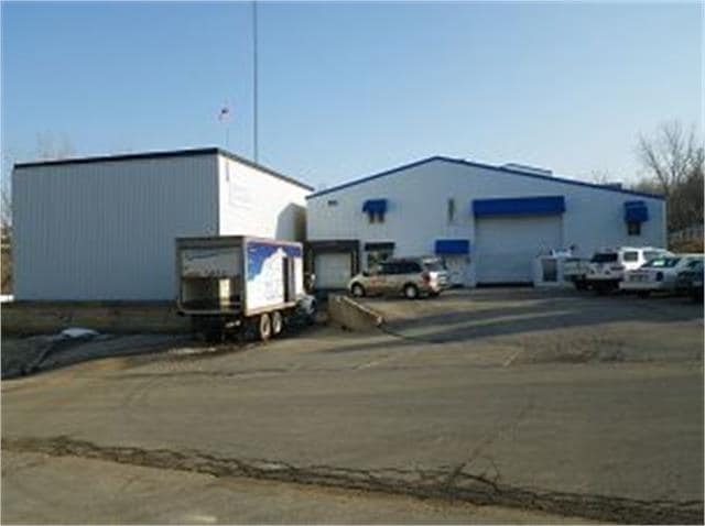
Property Detail
19 Nightengale Ln
10-34-101-008
LOT 1-1 BILL'S PLACE
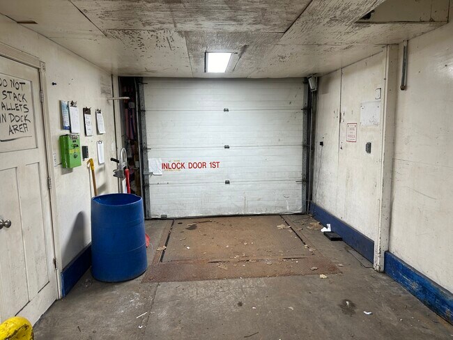
Manufacturinglight
Dubuque
CI
Iowa
B and X Area of moderate flood hazard, usually the area between the limits of the 100-year and 500-year floods.
1
2025
0.58 AC
2025
Iowa Northeast Area
000600
Other Market Areas
11,026 SF
Dubuque, IA
NEARBY LISTINGS FOR SALE OR LEASE
DEMOGRAPHICS near 19 Nightengale Ln
1 mile
3 mile
5 mile
2025 Total Population
1,624
44,620
73,497
2030 Population
1,631
44,820
73,673
Pop Growth 2025-2030
+ 0.43%
+ 0.45%
+ 0.24%
Average Age
49
41
41
2025 Total Households
766
18,556
30,211
HH Growth 2025-2030
+ 0.39%
+ 0.51%
+ 0.25%
Median Household Inc
$83,169
$70,412
$68,241
Avg Household Size
2.00
2.20
2.30
2025 Avg HH Vehicles
2.00
2.00
2.00
Median Home Value
$261,802
$232,428
$224,752
Median Year Built
1987
1968
1967
Nearby Places
Map Layers
Map Styles
 Street
 Aerial
Layers
 Traffic
 Biking
Places
Listings with unknown addresses are not visible on the map
- Restaurants
- Banks
- Shops
- Fitness
- Groceries
SALE & LEASE HISTORY
LISTING DATE
SALE/LEASE

Feb 06, 2025
For Lease
Nearby Properties
Address
Land Use
TOTAL SIZE
Lot Size
Zoning
Address
Land Use
TOTAL SIZE
Lot Size
Zoning
58,956 SF
18.52 AC
Address
Land Use
TOTAL SIZE
Lot Size
Zoning
276,146 SF
34.71 AC
Address
Land Use
TOTAL SIZE
Lot Size
Zoning
21.73 AC
Address
Land Use
TOTAL SIZE
Lot Size
Zoning
6.48 AC
Address
Land Use
TOTAL SIZE
Lot Size
Zoning
30,012 SF
46.55 AC
CI
Address
Land Use
TOTAL SIZE
Lot Size
Zoning
148,824 SF
6.79 AC
Address
Land Use
TOTAL SIZE
Lot Size
Zoning
3,672 SF
18.81 AC
Address
Land Use
TOTAL SIZE
Lot Size
Zoning
242 SF
39.55 AC
Address
Land Use
TOTAL SIZE
Lot Size
Zoning
277,394 SF
40 AC
Address
Land Use
TOTAL SIZE
Lot Size
Zoning
332,034 SF
21.78 AC
CI
Address
Land Use
TOTAL SIZE
Lot Size
Zoning
43.61 AC
Address
Land Use
TOTAL SIZE
Lot Size
Zoning
281,465 SF
26.81 AC
Address
Land Use
TOTAL SIZE
Lot Size
Zoning
101,989 SF
26.38 AC
CI
Address
Land Use
TOTAL SIZE
Lot Size
Zoning
244,700 SF
39.22 AC
Address
Land Use
TOTAL SIZE
Lot Size
Zoning
300 SF
29.95 AC
CI
Address
Land Use
TOTAL SIZE
Lot Size
Zoning
42,400 SF
17.09 AC
Address
Land Use
TOTAL SIZE
Lot Size
Zoning
Address
Land Use
TOTAL SIZE
Lot Size
Zoning
120,000 SF
20.47 AC
Address
Land Use
TOTAL SIZE
Lot Size
Zoning
262,314 SF
0.67 AC
CI
Address
Land Use
TOTAL SIZE
Lot Size
Zoning
108,417 SF
2.60 AC
Address
Land Use
TOTAL SIZE
Lot Size
Zoning
216,000 SF
16.69 AC
Address
Land Use
TOTAL SIZE
Lot Size
Zoning
117,636 SF
21.83 AC
Address
Land Use
TOTAL SIZE
Lot Size
Zoning
136,429 SF
21.91 AC
CI
Address
Land Use
TOTAL SIZE
Lot Size
Zoning
94,400 SF
1.83 AC
Address
Land Use
TOTAL SIZE
Lot Size
Zoning
52,543 SF
9.44 AC
Address
Land Use
TOTAL SIZE
Lot Size
Zoning
200,100 SF
11.26 AC
Address
Land Use
TOTAL SIZE
Lot Size
Zoning
192,119 SF
10 AC
CI
Address
Land Use
TOTAL SIZE
Lot Size
Zoning
162,300 SF
23.94 AC
CI
Address
Land Use
TOTAL SIZE
Lot Size
Zoning
120,800 SF
13.91 AC
CI
Address
Land Use
TOTAL SIZE
Lot Size
Zoning
3.46 AC
The World's #1 Commercial Real Estate Marketplace
Connect with us
© 2026 CoStar Group
The information above has been obtained from sources believed reliable. While we do not doubt its accuracy we have not verified it and make no guarantee, warranty or representation about it. It is your responsibility to independently confirm its accuracy and completeness. Any projections, opinions, assumptions, or estimates used are for example only and do not represent the current or future performance of the property. The value of this transaction to you depends on tax and other factors which should be evaluated by your tax, financial, and legal advisors. You and your advisors should conduct a careful, independent investigation of the property to determine to your satisfaction the suitability of the property for your needs.