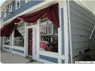
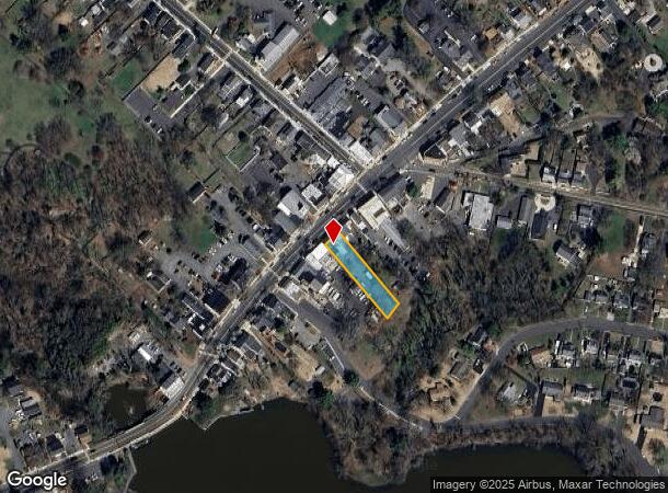
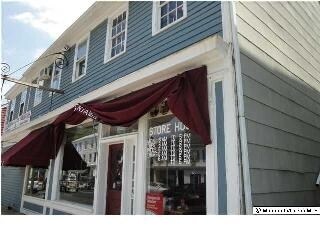
Property Record
19 S Main St, Allentown, NJ 08501
NEARBY LISTINGS FOR SALE OR LEASE
-
-
View all Allentown listings for sale on LoopNet.com
Property Detail
19 S Main St
03-00009-0000-00033
Monmouth
Commercialnec
New Jersey
X
33
34021C0262F
0.33 AC
2024
Western Monmouth
2025
Northern New Jersey
812000
New York-Jersey City-White Plains, NY-NJ
3,616 SF
DEMOGRAPHICS near 19 S Main St
1 Mile
3 Mile
5 Mile
2024 Total Population
2,464
9,672
43,710
2029 Population
2,403
9,501
43,298
Pop Growth 2024-2029
(2.48%)
(1.77%)
(0.94%)
Average Age
43
44
42
2024 Total Households
930
3,349
15,741
HH Growth 2024-2029
(2.80%)
(2.03%)
(1.17%)
Median Household Inc
$129,237
$159,508
$126,446
Avg Household Size
2.60
2.90
2.70
2024 Avg HH Vehicles
2.00
2.00
2.00
Median Home Value
$451,117
$529,321
$396,131
Median Year Built
1971
1989
1985
Nearby Places
Map Layers
Map Styles
 Street
 Aerial
- Restaurants
- Banks
- Shops
- Fitness
- Groceries
PUBLIC TRANSPORTATION
COMMUTER RAIL
Hamilton (Northeast Corridor Line - NJ Transit Commuter Rail (NJ Transit))
DRIVE
WALK
Distance
Hamilton (Northeast Corridor Line - NJ Transit Commuter Rail (NJ Transit))
21 min
9.7 mi
AIRPORT
Trenton Mercer
DRIVE
WALK
Distance
Trenton Mercer
31 min
19.5 mi
Freight Ports
South Jersey Port
DRIVE
WALK
Distance
South Jersey Port
57 min
37.8 mi
Nearby Properties
Address
Land Use
TOTAL SIZE
Lot Size
Zoning
Address
Land Use
TOTAL SIZE
Lot Size
Zoning
55.71 AC
PCD
Address
Land Use
TOTAL SIZE
Lot Size
Zoning
64.43 AC
PCD
Address
Land Use
TOTAL SIZE
Lot Size
Zoning
65.18 AC
PCD
Address
Land Use
TOTAL SIZE
Lot Size
Zoning
47.91 AC
PCD
Address
Land Use
TOTAL SIZE
Lot Size
Zoning
79.71 AC
PCD
Address
Land Use
TOTAL SIZE
Lot Size
Zoning
60.18 AC
PCD
Address
Land Use
TOTAL SIZE
Lot Size
Zoning
56.90 AC
RD
Address
Land Use
TOTAL SIZE
Lot Size
Zoning
134,000 SF
117.90 AC
AR
Address
Land Use
TOTAL SIZE
Lot Size
Zoning
37.90 AC
PCD
Address
Land Use
TOTAL SIZE
Lot Size
Zoning
64,184 SF
8.53 AC
R85
Address
Land Use
TOTAL SIZE
Lot Size
Zoning
104.44 AC
PCD
Address
Land Use
TOTAL SIZE
Lot Size
Zoning
22.91 AC
PCD
Address
Land Use
TOTAL SIZE
Lot Size
Zoning
30.70 AC
PCD
Address
Land Use
TOTAL SIZE
Lot Size
Zoning
38.78 AC
PCD
Address
Land Use
TOTAL SIZE
Lot Size
Zoning
46.35 AC
PCD
Address
Land Use
TOTAL SIZE
Lot Size
Zoning
17.06 AC
RD
Address
Land Use
TOTAL SIZE
Lot Size
Zoning
11.16 AC
PCD
Address
Land Use
TOTAL SIZE
Lot Size
Zoning
22.73 AC
PCD
Address
Land Use
TOTAL SIZE
Lot Size
Zoning
10 AC
PCD
Address
Land Use
TOTAL SIZE
Lot Size
Zoning
79.71 AC
PCD
Address
Land Use
TOTAL SIZE
Lot Size
Zoning
21.51 AC
PCD
Address
Land Use
TOTAL SIZE
Lot Size
Zoning
23.18 AC
PCD
Address
Land Use
TOTAL SIZE
Lot Size
Zoning
15,488 SF
34.01 AC
PEC
Address
Land Use
TOTAL SIZE
Lot Size
Zoning
12.52 AC
RD
Address
Land Use
TOTAL SIZE
Lot Size
Zoning
7.51 AC
PCD
Address
Land Use
TOTAL SIZE
Lot Size
Zoning
19,070 SF
6.39 AC
Address
Land Use
TOTAL SIZE
Lot Size
Zoning
15.62 AC
PCD
Address
Land Use
TOTAL SIZE
Lot Size
Zoning
12.98 AC
PCD
Address
Land Use
TOTAL SIZE
Lot Size
Zoning
85,838 SF
9.74 AC
GI
Address
Land Use
TOTAL SIZE
Lot Size
Zoning
20.20 AC
RR
The World's #1 Commercial Real Estate Marketplace
Connect with us
© 2025 CoStar Group
The information above has been obtained from sources believed reliable. While we do not doubt its accuracy we have not verified it and make no guarantee, warranty or representation about it. It is your responsibility to independently confirm its accuracy and completeness. Any projections, opinions, assumptions, or estimates used are for example only and do not represent the current or future performance of the property. The value of this transaction to you depends on tax and other factors which should be evaluated by your tax, financial, and legal advisors. You and your advisors should conduct a careful, independent investigation of the property to determine to your satisfaction the suitability of the property for your needs.