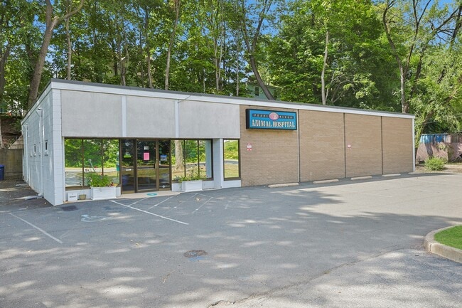
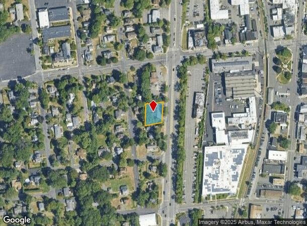
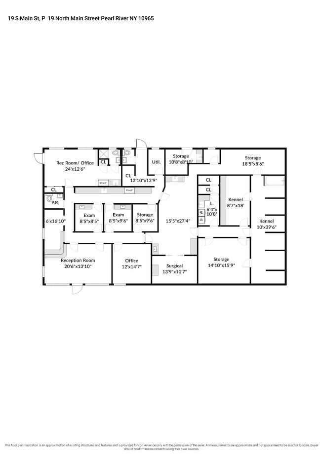
Property Record
19 S Pearl St, Pearl River, NY 10965
NEARBY LISTINGS FOR SALE OR LEASE
Property Detail
19 S Pearl St
New York-Jersey City-White Plains, NY-NJ
40/3/41/3
392489-068-019-0004-009-000-0000
Rockland
Kennel
New York
X
9.0
34003C0092H
0.29 AC
2023
Orangetown
2024
Northern New Jersey
012700
DEMOGRAPHICS near 19 S Pearl St
1 Mile
3 Mile
5 Mile
2024 Total Population
12,005
67,335
230,218
2029 Population
12,326
69,844
237,523
Pop Growth 2024-2029
+ 2.67%
+ 3.73%
+ 3.17%
Average Age
41
42
38
2024 Total Households
4,380
23,033
71,304
HH Growth 2024-2029
+ 2.63%
+ 3.79%
+ 3.30%
Median Household Inc
$134,029
$152,662
$122,778
Avg Household Size
2.70
2.80
3.10
2024 Avg HH Vehicles
2.00
2.00
2.00
Median Home Value
$666,593
$728,555
$730,135
Median Year Built
1957
1965
1968
Nearby Places
- Restaurants
- Banks
- Shops
- Fitness
- Groceries
PUBLIC TRANSPORTATION
TRANSIT/SUBWAY
Pearl River (Pascack Valley Line - NJ Transit Commuter Rail (NJ Transit))
DRIVE
WALK
Distance
Pearl River (Pascack Valley Line - NJ Transit Commuter Rail (NJ Transit))
1 min
4 min
0.2 mi
COMMUTER RAIL
Pearl River (Pascack Valley Line - NJ Transit Commuter Rail (NJ Transit))
DRIVE
WALK
Distance
Pearl River (Pascack Valley Line - NJ Transit Commuter Rail (NJ Transit))
1 min
4 min
0.2 mi
Montvale (Pascack Valley Line - NJ Transit Commuter Rail (NJ Transit))
DRIVE
WALK
Distance
Montvale (Pascack Valley Line - NJ Transit Commuter Rail (NJ Transit))
2 min
1.3 mi
AIRPORT
Westchester County
DRIVE
WALK
Distance
Westchester County
37 min
25.0 mi
LaGuardia
DRIVE
WALK
Distance
LaGuardia
46 min
28.2 mi
Newark Liberty International
DRIVE
WALK
Distance
Newark Liberty International
42 min
30.9 mi
Freight Ports
Maher Terminal
DRIVE
WALK
Distance
Maher Terminal
51 min
33.9 mi
SALE & LEASE HISTORY
LISTING DATE
SALE/LEASE

Sep 05, 2025
For Sale
Nearby Properties
Address
Land Use
TOTAL SIZE
Lot Size
Zoning
Address
Land Use
TOTAL SIZE
Lot Size
Zoning
Address
Land Use
TOTAL SIZE
Lot Size
Zoning
205,580 SF
21.18 AC
EO
Address
Land Use
TOTAL SIZE
Lot Size
Zoning
402,385 SF
23.10 AC
LI
Address
Land Use
TOTAL SIZE
Lot Size
Zoning
63,621 SF
180.20 AC
LI
Address
Land Use
TOTAL SIZE
Lot Size
Zoning
Address
Land Use
TOTAL SIZE
Lot Size
Zoning
7.04 AC
SED
Address
Land Use
TOTAL SIZE
Lot Size
Zoning
Address
Land Use
TOTAL SIZE
Lot Size
Zoning
Address
Land Use
TOTAL SIZE
Lot Size
Zoning
13 AC
EAO
Address
Land Use
TOTAL SIZE
Lot Size
Zoning
22.75 AC
Address
Land Use
TOTAL SIZE
Lot Size
Zoning
11.48 AC
OR-3
Address
Land Use
TOTAL SIZE
Lot Size
Zoning
9.29 AC
SED
Address
Land Use
TOTAL SIZE
Lot Size
Zoning
17 AC
OR1
Address
Land Use
TOTAL SIZE
Lot Size
Zoning
36.49 AC
OR-2
Address
Land Use
TOTAL SIZE
Lot Size
Zoning
31.79 AC
OR2
Address
Land Use
TOTAL SIZE
Lot Size
Zoning
Address
Land Use
TOTAL SIZE
Lot Size
Zoning
37,600 SF
31.41 AC
Address
Land Use
TOTAL SIZE
Lot Size
Zoning
2,374 SF
1.80 AC
SOII
Address
Land Use
TOTAL SIZE
Lot Size
Zoning
71,166 SF
7.26 AC
B3
Address
Land Use
TOTAL SIZE
Lot Size
Zoning
24.45 AC
R40
Address
Land Use
TOTAL SIZE
Lot Size
Zoning
1,295,615 SF
93.54 AC
OP
Address
Land Use
TOTAL SIZE
Lot Size
Zoning
9.19 AC
OR2
Address
Land Use
TOTAL SIZE
Lot Size
Zoning
29.86 AC
ORL
Address
Land Use
TOTAL SIZE
Lot Size
Zoning
89,200 SF
8 AC
SOII
Address
Land Use
TOTAL SIZE
Lot Size
Zoning
440 SF
98.43 AC
EO
Address
Land Use
TOTAL SIZE
Lot Size
Zoning
8.02 AC
BUS2
Address
Land Use
TOTAL SIZE
Lot Size
Zoning
11.45 AC
A
Address
Land Use
TOTAL SIZE
Lot Size
Zoning
63,060 SF
3.40 AC
Address
Land Use
TOTAL SIZE
Lot Size
Zoning
14.56 AC
ORL
Address
Land Use
TOTAL SIZE
Lot Size
Zoning
132,614 SF
15.74 AC
OR3
The World's #1 Commercial Real Estate Marketplace
Connect with us
© 2025 CoStar Group
The information above has been obtained from sources believed reliable. While we do not doubt its accuracy we have not verified it and make no guarantee, warranty or representation about it. It is your responsibility to independently confirm its accuracy and completeness. Any projections, opinions, assumptions, or estimates used are for example only and do not represent the current or future performance of the property. The value of this transaction to you depends on tax and other factors which should be evaluated by your tax, financial, and legal advisors. You and your advisors should conduct a careful, independent investigation of the property to determine to your satisfaction the suitability of the property for your needs.