Property Record
19 Roosevelt Hwy, Colchester, VT 05446
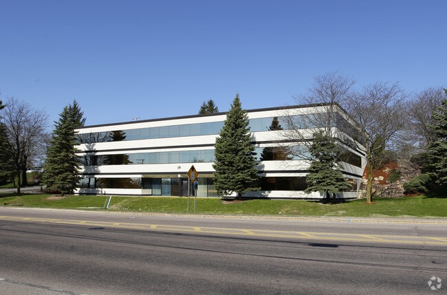
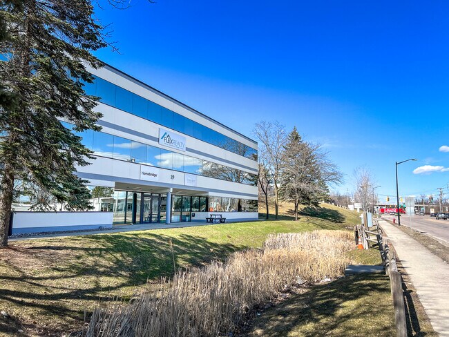
This Property Is For Sale
NEARBY LISTINGS FOR SALE OR LEASE
Property Detail
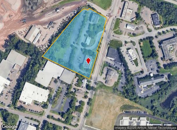
19 Roosevelt Hwy
(048) 03-0070030000000
19 ROOSEVELT HWY ##20
Officecondo
Chittenden
AE
Vermont
50007C0127D
0.09 AC
2024
Vermont North Area
2024
Other Market Areas
002201
Burlington-South Burlington, VT
8,296 SF
DEMOGRAPHICS near 19 Roosevelt Hwy
1 Mile
3 Mile
5 Mile
2024 Total Population
8,727
54,360
100,049
2029 Population
8,856
55,019
101,334
Pop Growth 2024-2029
+ 1.48%
+ 1.21%
+ 1.28%
Average Age
38
35
38
2024 Total Households
4,089
21,918
41,749
HH Growth 2024-2029
+ 1.27%
+ 1.31%
+ 1.38%
Median Household Inc
$63,305
$61,458
$74,128
Avg Household Size
2.00
2.10
2.10
2024 Avg HH Vehicles
1.00
1.00
2.00
Median Home Value
$304,067
$334,841
$355,942
Median Year Built
1968
1967
1974
Nearby Places
- Restaurants
- Banks
- Shops
- Fitness
- Groceries
PUBLIC TRANSPORTATION
COMMUTER RAIL
Btn (Ethan Allen Express - Amtrak)
DRIVE
WALK
Distance
Btn (Ethan Allen Express - Amtrak)
8 min
3.3 mi
Essex Junction-Burlington Amtrak Station (Vermonter - Amtrak)
DRIVE
WALK
Distance
Essex Junction-Burlington Amtrak Station (Vermonter - Amtrak)
12 min
5.0 mi
AIRPORT
Patrick Leahy Burlington International
DRIVE
WALK
Distance
Patrick Leahy Burlington International
12 min
3.6 mi
Plattsburgh International
DRIVE
WALK
Distance
Plattsburgh International
61 min
31.0 mi
Freight Ports
Montreal
DRIVE
WALK
Distance
Montreal
120 min
94.3 mi
Nearby Properties
Address
Land Use
TOTAL SIZE
Lot Size
Zoning
Address
Land Use
TOTAL SIZE
Lot Size
Zoning
2,542,351 SF
34.82 AC
I
Address
Land Use
TOTAL SIZE
Lot Size
Zoning
168,175 SF
I
Address
Land Use
TOTAL SIZE
Lot Size
Zoning
2.96 AC
I
Address
Land Use
TOTAL SIZE
Lot Size
Zoning
12.26 AC
I
Address
Land Use
TOTAL SIZE
Lot Size
Zoning
Address
Land Use
TOTAL SIZE
Lot Size
Zoning
27.70 AC
Address
Land Use
TOTAL SIZE
Lot Size
Zoning
232,277 SF
17.20 AC
I
Address
Land Use
TOTAL SIZE
Lot Size
Zoning
Address
Land Use
TOTAL SIZE
Lot Size
Zoning
167,016 SF
2.30 AC
I
Address
Land Use
TOTAL SIZE
Lot Size
Zoning
32.43 AC
I
Address
Land Use
TOTAL SIZE
Lot Size
Zoning
1.70 AC
FD6
Address
Land Use
TOTAL SIZE
Lot Size
Zoning
19.86 AC
I
Address
Land Use
TOTAL SIZE
Lot Size
Zoning
98,123 SF
I
Address
Land Use
TOTAL SIZE
Lot Size
Zoning
20.87 AC
RL
Address
Land Use
TOTAL SIZE
Lot Size
Zoning
Address
Land Use
TOTAL SIZE
Lot Size
Zoning
157,081 SF
I
Address
Land Use
TOTAL SIZE
Lot Size
Zoning
1.16 AC
FD6
Address
Land Use
TOTAL SIZE
Lot Size
Zoning
181,068 SF
I
Address
Land Use
TOTAL SIZE
Lot Size
Zoning
140,910 SF
2.72 AC
I
Address
Land Use
TOTAL SIZE
Lot Size
Zoning
2.06 AC
FD6
Address
Land Use
TOTAL SIZE
Lot Size
Zoning
6.50 AC
I
Address
Land Use
TOTAL SIZE
Lot Size
Zoning
68,321 SF
4.60 AC
I
Address
Land Use
TOTAL SIZE
Lot Size
Zoning
119,561 SF
1.86 AC
FD5
Address
Land Use
TOTAL SIZE
Lot Size
Zoning
8,680 SF
45.56 AC
EAE
Address
Land Use
TOTAL SIZE
Lot Size
Zoning
140.43 AC
I
Address
Land Use
TOTAL SIZE
Lot Size
Zoning
107,141 SF
I
Address
Land Use
TOTAL SIZE
Lot Size
Zoning
472,662 SF
23.37 AC
Address
Land Use
TOTAL SIZE
Lot Size
Zoning
Address
Land Use
TOTAL SIZE
Lot Size
Zoning
3.38 AC
FD6
Address
Land Use
TOTAL SIZE
Lot Size
Zoning
78,064 SF
2.71 AC
The World's #1 Commercial Real Estate Marketplace
Connect with us
© 2025 CoStar Group
The information above has been obtained from sources believed reliable. While we do not doubt its accuracy we have not verified it and make no guarantee, warranty or representation about it. It is your responsibility to independently confirm its accuracy and completeness. Any projections, opinions, assumptions, or estimates used are for example only and do not represent the current or future performance of the property. The value of this transaction to you depends on tax and other factors which should be evaluated by your tax, financial, and legal advisors. You and your advisors should conduct a careful, independent investigation of the property to determine to your satisfaction the suitability of the property for your needs.