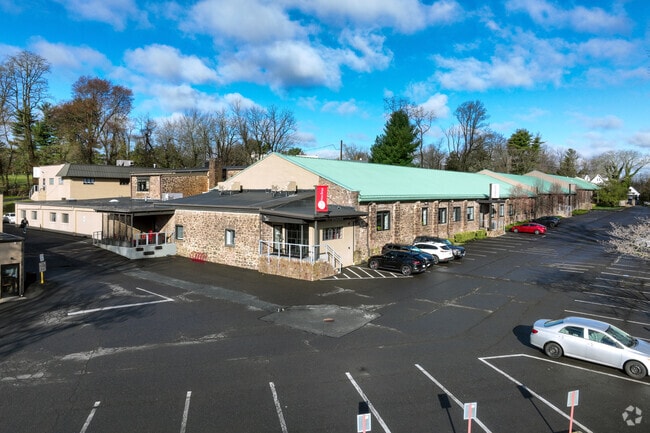
Property Record
19 W College Ave, Yardley, PA 19067

Current Lease Availabilities
Property Detail
19 W College Ave
54-007-002
10.3969AC SS OF W COLLEGE AV214FT W OF S MAIN ST
Officebuilding
Bucks
I-1
Pennsylvania
AE The base floodplain where base flood elevations are provided. AE Zones are now used on new format FIRMs instead of A1-A30 Zones.
10.40 AC
2025
Lower Bucks County
2026
Philadelphia
105600
Philadelphia-Camden-Wilmington, PA-NJ-DE-MD
34,266 SF
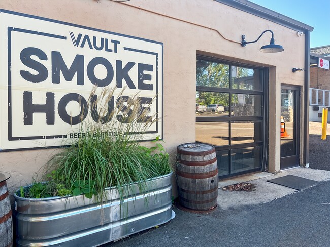
NEARBY LISTINGS FOR SALE OR LEASE
DEMOGRAPHICS near 19 W College Ave
1 mile
3 mile
5 mile
2025 Total Population
6,516
66,758
194,505
2030 Population
6,531
68,080
198,921
Pop Growth 2025-2030
+ 0.23%
+ 1.98%
+ 2.27%
Average Age
45
43
42
2025 Total Households
2,769
26,510
74,134
HH Growth 2025-2030
+ 0.33%
+ 2.47%
+ 2.50%
Median Household Inc
$137,741
$107,518
$89,332
Avg Household Size
2.30
2.40
2.50
2025 Avg HH Vehicles
2.00
2.00
2.00
Median Home Value
$630,364
$479,415
$399,519
Median Year Built
1965
1969
1963
Nearby Places
Map Layers
Map Styles
 Street
 Aerial
Layers
 Traffic
 Biking
Places
Listings with unknown addresses are not visible on the map
- Restaurants
- Banks
- Shops
- Fitness
- Groceries
PUBLIC TRANSPORTATION
COMMUTER RAIL
Yardley (R3 - Southeastern Pennsylvania Transportation Authority Regional Rail (SEPTA Regional Rail))
Drive
Walk
Distance
Yardley (R3 - Southeastern Pennsylvania Transportation Authority Regional Rail (SEPTA Regional Rail))
2 min
14 min
0.7 mi
West Trenton (R3 - Southeastern Pennsylvania Transportation Authority Regional Rail (SEPTA Regional Rail))
Drive
Walk
Distance
West Trenton (R3 - Southeastern Pennsylvania Transportation Authority Regional Rail (SEPTA Regional Rail))
10 min
5.3 mi
AIRPORT
Trenton Mercer
Drive
Walk
Distance
Trenton Mercer
10 min
4.7 mi
Freight Ports
Port of Philadelphia
Drive
Walk
Distance
Port of Philadelphia
40 min
27.4 mi
Nearby Properties
Address
Land Use
TOTAL SIZE
Lot Size
Zoning
Address
Land Use
TOTAL SIZE
Lot Size
Zoning
225.40 AC
R-1
Address
Land Use
TOTAL SIZE
Lot Size
Zoning
1,996 SF
125 AC
RA
Address
Land Use
TOTAL SIZE
Lot Size
Zoning
4,320 SF
12.06 AC
PRO
Address
Land Use
TOTAL SIZE
Lot Size
Zoning
96.60 AC
OP-2
Address
Land Use
TOTAL SIZE
Lot Size
Zoning
117.50 AC
OP-1
Address
Land Use
TOTAL SIZE
Lot Size
Zoning
60,000 SF
42.80 AC
IP-1
Address
Land Use
TOTAL SIZE
Lot Size
Zoning
27.21 AC
PRO
Address
Land Use
TOTAL SIZE
Lot Size
Zoning
104.60 AC
IP-1
Address
Land Use
TOTAL SIZE
Lot Size
Zoning
23.50 AC
R-2
Address
Land Use
TOTAL SIZE
Lot Size
Zoning
11.40 AC
Address
Land Use
TOTAL SIZE
Lot Size
Zoning
64.33 AC
R-2
Address
Land Use
TOTAL SIZE
Lot Size
Zoning
12.54 AC
IP-1
Address
Land Use
TOTAL SIZE
Lot Size
Zoning
8.93 AC
Address
Land Use
TOTAL SIZE
Lot Size
Zoning
5,254 SF
245.70 AC
R-1
Address
Land Use
TOTAL SIZE
Lot Size
Zoning
11.09 AC
Address
Land Use
TOTAL SIZE
Lot Size
Zoning
26.20 AC
OP-1
Address
Land Use
TOTAL SIZE
Lot Size
Zoning
63.40 AC
R-1
Address
Land Use
TOTAL SIZE
Lot Size
Zoning
1.30 AC
Address
Land Use
TOTAL SIZE
Lot Size
Zoning
8.46 AC
RA
Address
Land Use
TOTAL SIZE
Lot Size
Zoning
35.41 AC
R-M
Address
Land Use
TOTAL SIZE
Lot Size
Zoning
1.81 AC
IP-1
Address
Land Use
TOTAL SIZE
Lot Size
Zoning
17,832 SF
26.01 AC
RM
Address
Land Use
TOTAL SIZE
Lot Size
Zoning
896 SF
20.71 AC
R-2
Address
Land Use
TOTAL SIZE
Lot Size
Zoning
27.82 AC
R-M
Address
Land Use
TOTAL SIZE
Lot Size
Zoning
Address
Land Use
TOTAL SIZE
Lot Size
Zoning
34.18 AC
R-2
Address
Land Use
TOTAL SIZE
Lot Size
Zoning
44.90 AC
R-2
Address
Land Use
TOTAL SIZE
Lot Size
Zoning
6,444 SF
44.01 AC
RA
Address
Land Use
TOTAL SIZE
Lot Size
Zoning
30.72 AC
R-1
Address
Land Use
TOTAL SIZE
Lot Size
Zoning
21,400 SF
25.20 AC
IP-1
The World's #1 Commercial Real Estate Marketplace
Connect with us
© 2026 CoStar Group
The information above has been obtained from sources believed reliable. While we do not doubt its accuracy we have not verified it and make no guarantee, warranty or representation about it. It is your responsibility to independently confirm its accuracy and completeness. Any projections, opinions, assumptions, or estimates used are for example only and do not represent the current or future performance of the property. The value of this transaction to you depends on tax and other factors which should be evaluated by your tax, financial, and legal advisors. You and your advisors should conduct a careful, independent investigation of the property to determine to your satisfaction the suitability of the property for your needs.