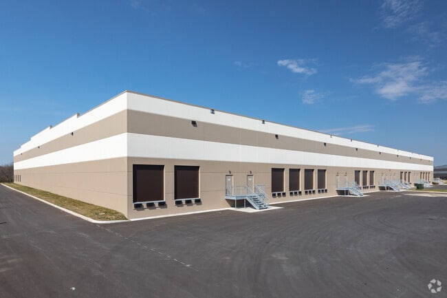
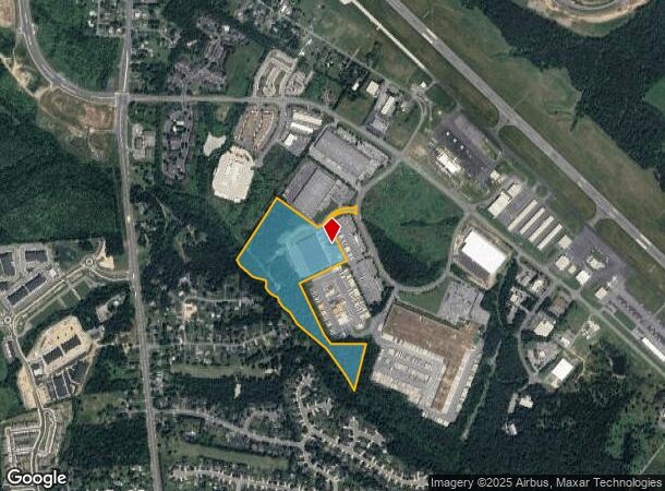
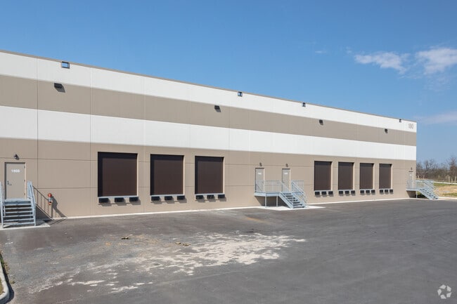
Property Record
190 Admiral Byrd Dr, Winchester, VA 22602
NEARBY LISTINGS FOR SALE OR LEASE
Property Detail
190 Admiral Byrd Dr
64A-40P
Airport Business Prk
Multipleuses
24.51 ACRES PARCEL E
A
Frederick
51069C0219E
Virginia
2025
24.51 AC
2025
Frederick County VA
050900
Washington, DC
89,500 SF
Winchester, VA-WV
DEMOGRAPHICS near 190 Admiral Byrd Dr
1 Mile
3 Mile
5 Mile
2024 Total Population
3,124
33,086
79,828
2029 Population
3,585
34,624
84,817
Pop Growth 2024-2029
+ 14.76%
+ 4.65%
+ 6.25%
Average Age
39
39
39
2024 Total Households
1,156
12,668
30,052
HH Growth 2024-2029
+ 14.71%
+ 4.38%
+ 5.94%
Median Household Inc
$53,439
$68,039
$74,175
Avg Household Size
2.60
2.50
2.50
2024 Avg HH Vehicles
2.00
2.00
2.00
Median Home Value
$331,609
$314,543
$307,312
Median Year Built
1996
1984
1986
Nearby Places
- Restaurants
- Banks
- Shops
- Fitness
- Groceries
SALE & LEASE HISTORY
LISTING DATE
SALE/LEASE

May 19, 2020
For Lease
Nearby Properties
Address
Land Use
TOTAL SIZE
Lot Size
Zoning
Address
Land Use
TOTAL SIZE
Lot Size
Zoning
64.27 AC
M1
Address
Land Use
TOTAL SIZE
Lot Size
Zoning
56,582 SF
35.39 AC
M1
Address
Land Use
TOTAL SIZE
Lot Size
Zoning
31,710 SF
47.28 AC
HE1
Address
Land Use
TOTAL SIZE
Lot Size
Zoning
375,081 SF
74.09 AC
M2
Address
Land Use
TOTAL SIZE
Lot Size
Zoning
156,379 SF
55.53 AC
RA
Address
Land Use
TOTAL SIZE
Lot Size
Zoning
1,440 SF
6.73 AC
RA
Address
Land Use
TOTAL SIZE
Lot Size
Zoning
30,054 SF
62.32 AC
M2
Address
Land Use
TOTAL SIZE
Lot Size
Zoning
411,597 SF
32.20 AC
M1
Address
Land Use
TOTAL SIZE
Lot Size
Zoning
225,042 SF
56.33 AC
B2
Address
Land Use
TOTAL SIZE
Lot Size
Zoning
15.24 AC
RP
Address
Land Use
TOTAL SIZE
Lot Size
Zoning
191,138 SF
35 AC
EIP
Address
Land Use
TOTAL SIZE
Lot Size
Zoning
11,979 SF
10.82 AC
HR
Address
Land Use
TOTAL SIZE
Lot Size
Zoning
254,560 SF
42.88 AC
M1
Address
Land Use
TOTAL SIZE
Lot Size
Zoning
462,500 SF
53.51 AC
B2
Address
Land Use
TOTAL SIZE
Lot Size
Zoning
351,500 SF
28.38 AC
M1
Address
Land Use
TOTAL SIZE
Lot Size
Zoning
422,658 SF
64.27 AC
M1
Address
Land Use
TOTAL SIZE
Lot Size
Zoning
27,464 SF
8.53 AC
B2
Address
Land Use
TOTAL SIZE
Lot Size
Zoning
231,756 SF
23.66 AC
CM1
Address
Land Use
TOTAL SIZE
Lot Size
Zoning
151,711 SF
16.25 AC
CM1
Address
Land Use
TOTAL SIZE
Lot Size
Zoning
181,832 SF
17.96 AC
CM1
Address
Land Use
TOTAL SIZE
Lot Size
Zoning
153,024 SF
33.47 AC
EIP
Address
Land Use
TOTAL SIZE
Lot Size
Zoning
64,711 SF
18.10 AC
B2
Address
Land Use
TOTAL SIZE
Lot Size
Zoning
2,310 SF
17.28 AC
RP
Address
Land Use
TOTAL SIZE
Lot Size
Zoning
94,606 SF
4.92 AC
B2
Address
Land Use
TOTAL SIZE
Lot Size
Zoning
252,000 SF
24.87 AC
M1
Address
Land Use
TOTAL SIZE
Lot Size
Zoning
440,999 SF
55.46 AC
M1
Address
Land Use
TOTAL SIZE
Lot Size
Zoning
87,000 SF
16.30 AC
EIP
Address
Land Use
TOTAL SIZE
Lot Size
Zoning
83,786 SF
2.71 AC
HE1
Address
Land Use
TOTAL SIZE
Lot Size
Zoning
43,232 SF
169.19 AC
EIP
Address
Land Use
TOTAL SIZE
Lot Size
Zoning
12,000 SF
8.78 AC
CM1
The World's #1 Commercial Real Estate Marketplace
Connect with us
© 2025 CoStar Group
The information above has been obtained from sources believed reliable. While we do not doubt its accuracy we have not verified it and make no guarantee, warranty or representation about it. It is your responsibility to independently confirm its accuracy and completeness. Any projections, opinions, assumptions, or estimates used are for example only and do not represent the current or future performance of the property. The value of this transaction to you depends on tax and other factors which should be evaluated by your tax, financial, and legal advisors. You and your advisors should conduct a careful, independent investigation of the property to determine to your satisfaction the suitability of the property for your needs.