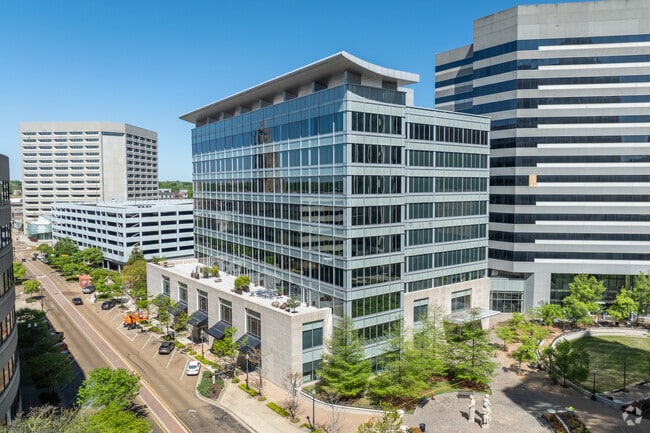
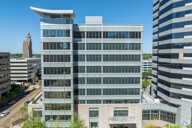
Property Record
190 E Capitol St, Jackson, MS 39201

Current Lease Availabilities
Property Detail
190 E Capitol St
Jackson, MS
BEG INT W/L LAMAR ST & N/L CAPITOL ST NWLY 403.24 FT NELY 218.91 FT ELY 264.51 FT S 10 FT ELY 42.86 FT NELY 152.2 FT ELY 9.59 FT SWLY 278.76 FT TO POB BEING PT 10 AC LOT 1 NJ & MCQUAID FITZGERALD SUBN SEE PARCEL #9085-8-3
0085-0008-003
HINDS
Commercialnec
Mississippi
C and X Area of minimal flood hazard, usually depicted on FIRMs as above the 500-year flood level.
1
2024
0.01 AC
2025
Downtown Jackson
002700
Jackson
237,090 SF
NEARBY LISTINGS FOR SALE OR LEASE
DEMOGRAPHICS near 190 E Capitol St
1 mile
3 mile
5 mile
2025 Total Population
4,571
38,033
106,707
2030 Population
4,505
38,030
105,264
Pop Growth 2025-2030
(1.44%)
(0.01%)
(1.35%)
Average Age
40
39
38
2025 Total Households
2,184
16,366
44,592
HH Growth 2025-2030
(1.65%)
(0.11%)
(1.53%)
Median Household Inc
$37,345
$32,122
$39,524
Avg Household Size
1.70
2.10
2.20
2025 Avg HH Vehicles
1.00
1.00
2.00
Median Home Value
$72,571
$77,490
$99,842
Median Year Built
1973
1961
1965
Nearby Places
Map Layers
Map Styles
 Street
 Aerial
Layers
 Traffic
 Biking
Places
Listings with unknown addresses are not visible on the map
- Restaurants
- Banks
- Shops
- Fitness
- Groceries
PUBLIC TRANSPORTATION
COMMUTER RAIL
Jackson (City of New Orleans - Amtrak)
Drive
Walk
Distance
Jackson (City of New Orleans - Amtrak)
0 min
6 min
0.3 mi
AIRPORT
Jackson-Medgar Wiley Evers International
Drive
Walk
Distance
Jackson-Medgar Wiley Evers International
20 min
12.0 mi
Freight Ports
Port of Greater Baton Rouge
Drive
Walk
Distance
Port of Greater Baton Rouge
197 min
176.7 mi
Nearby Properties
Address
Land Use
TOTAL SIZE
Lot Size
Zoning
Address
Land Use
TOTAL SIZE
Lot Size
Zoning
435,199 SF
1 AC
Address
Land Use
TOTAL SIZE
Lot Size
Zoning
560,993 SF
47 AC
Address
Land Use
TOTAL SIZE
Lot Size
Zoning
74,923 SF
0.01 AC
Address
Land Use
TOTAL SIZE
Lot Size
Zoning
9,650 SF
0.55 AC
Address
Land Use
TOTAL SIZE
Lot Size
Zoning
7.60 AC
Address
Land Use
TOTAL SIZE
Lot Size
Zoning
7,561 SF
153.82 AC
Address
Land Use
TOTAL SIZE
Lot Size
Zoning
Address
Land Use
TOTAL SIZE
Lot Size
Zoning
145,789 SF
6 AC
Address
Land Use
TOTAL SIZE
Lot Size
Zoning
206,400 SF
7.96 AC
Address
Land Use
TOTAL SIZE
Lot Size
Zoning
40,445 SF
3 AC
Address
Land Use
TOTAL SIZE
Lot Size
Zoning
51,260 SF
1 AC
Address
Land Use
TOTAL SIZE
Lot Size
Zoning
413,174 SF
2 AC
Address
Land Use
TOTAL SIZE
Lot Size
Zoning
96,444 SF
0.88 AC
Address
Land Use
TOTAL SIZE
Lot Size
Zoning
247,574 SF
0.94 AC
Address
Land Use
TOTAL SIZE
Lot Size
Zoning
45,186 SF
0.15 AC
Address
Land Use
TOTAL SIZE
Lot Size
Zoning
115,200 SF
0.35 AC
Address
Land Use
TOTAL SIZE
Lot Size
Zoning
17,261 SF
18.20 AC
Address
Land Use
TOTAL SIZE
Lot Size
Zoning
46,958 SF
0.77 AC
Address
Land Use
TOTAL SIZE
Lot Size
Zoning
32,886 SF
1 AC
Address
Land Use
TOTAL SIZE
Lot Size
Zoning
31,541 SF
4 AC
Address
Land Use
TOTAL SIZE
Lot Size
Zoning
30,925 SF
38.73 AC
Address
Land Use
TOTAL SIZE
Lot Size
Zoning
2,190,610 SF
2 AC
Address
Land Use
TOTAL SIZE
Lot Size
Zoning
47,885 SF
0.01 AC
Address
Land Use
TOTAL SIZE
Lot Size
Zoning
69,034 SF
0.64 AC
Address
Land Use
TOTAL SIZE
Lot Size
Zoning
40,148 SF
37.47 AC
Address
Land Use
TOTAL SIZE
Lot Size
Zoning
9,081 SF
0.73 AC
Address
Land Use
TOTAL SIZE
Lot Size
Zoning
55,591 SF
1 AC
Address
Land Use
TOTAL SIZE
Lot Size
Zoning
42,520 SF
0.22 AC
Address
Land Use
TOTAL SIZE
Lot Size
Zoning
0.01 AC
Address
Land Use
TOTAL SIZE
Lot Size
Zoning
The World's #1 Commercial Real Estate Marketplace
Connect with us
© 2026 CoStar Group
The information above has been obtained from sources believed reliable. While we do not doubt its accuracy we have not verified it and make no guarantee, warranty or representation about it. It is your responsibility to independently confirm its accuracy and completeness. Any projections, opinions, assumptions, or estimates used are for example only and do not represent the current or future performance of the property. The value of this transaction to you depends on tax and other factors which should be evaluated by your tax, financial, and legal advisors. You and your advisors should conduct a careful, independent investigation of the property to determine to your satisfaction the suitability of the property for your needs.