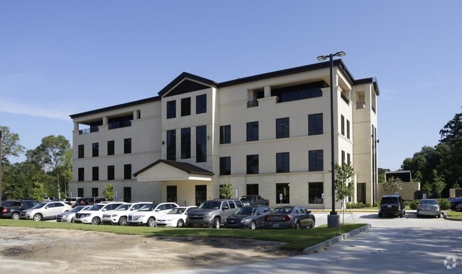
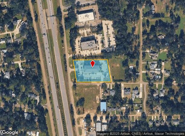
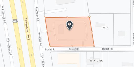
Property Record
190 E Highway Service Rd, Mandeville, LA 70448
NEARBY LISTINGS FOR SALE OR LEASE
Property Detail
190 E Highway Service Rd
Slidell-Mandeville-Covington, LA
Commercial N. Causeway Td 12
39876
2.210 ACS SEC 22 7 11 CB 299 490 INST NO 1051113 INST NO 1204891 INST NO 1522006 INST NO 1921167 INST NO 2187543
Commercialnec
St Tammany
ARE
Louisiana
2025
2.21 AC
2024
Mandeville/Covington
041209
New Orleans/Metairie/Kenner
48,866 SF
DEMOGRAPHICS near 190 E Highway Service Rd
1 Mile
3 Mile
5 Mile
2024 Total Population
4,856
43,677
94,668
2029 Population
5,222
46,837
101,620
Pop Growth 2024-2029
+ 7.54%
+ 7.23%
+ 7.34%
Average Age
41
42
41
2024 Total Households
1,806
17,278
37,234
HH Growth 2024-2029
+ 7.53%
+ 7.22%
+ 7.36%
Median Household Inc
$93,843
$82,895
$77,063
Avg Household Size
2.60
2.50
2.50
2024 Avg HH Vehicles
2.00
2.00
2.00
Median Home Value
$319,747
$330,821
$310,668
Median Year Built
1993
1995
1995
Nearby Places
Map Layers
Map Styles
 Street
 Aerial
- Restaurants
- Banks
- Shops
- Fitness
- Groceries
PUBLIC TRANSPORTATION
AIRPORT
Louis Armstrong New Orleans International
DRIVE
WALK
Distance
Louis Armstrong New Orleans International
52 min
37.8 mi
Freight Ports
Port of New Orleans
DRIVE
WALK
Distance
Port of New Orleans
56 min
38.8 mi
Nearby Properties
Address
Land Use
TOTAL SIZE
Lot Size
Zoning
Address
Land Use
TOTAL SIZE
Lot Size
Zoning
515,547 SF
20.54 AC
Address
Land Use
TOTAL SIZE
Lot Size
Zoning
178,608 SF
34.02 AC
Address
Land Use
TOTAL SIZE
Lot Size
Zoning
266,213 SF
40 AC
Address
Land Use
TOTAL SIZE
Lot Size
Zoning
229,994 SF
30 AC
Address
Land Use
TOTAL SIZE
Lot Size
Zoning
220,860 SF
25.07 AC
Address
Land Use
TOTAL SIZE
Lot Size
Zoning
154,751 SF
14.96 AC
Address
Land Use
TOTAL SIZE
Lot Size
Zoning
68,478 SF
6.64 AC
Address
Land Use
TOTAL SIZE
Lot Size
Zoning
165,168 SF
18.16 AC
Address
Land Use
TOTAL SIZE
Lot Size
Zoning
66,500 SF
4.35 AC
Address
Land Use
TOTAL SIZE
Lot Size
Zoning
102,470 SF
10.50 AC
Address
Land Use
TOTAL SIZE
Lot Size
Zoning
156,183 SF
20 AC
Address
Land Use
TOTAL SIZE
Lot Size
Zoning
57,360 SF
2.77 AC
Address
Land Use
TOTAL SIZE
Lot Size
Zoning
205,612 SF
23.60 AC
Address
Land Use
TOTAL SIZE
Lot Size
Zoning
131,925 SF
2.02 AC
Address
Land Use
TOTAL SIZE
Lot Size
Zoning
92,535 SF
2.80 AC
Address
Land Use
TOTAL SIZE
Lot Size
Zoning
2,053 SF
2 AC
Address
Land Use
TOTAL SIZE
Lot Size
Zoning
114,823 SF
4.57 AC
Address
Land Use
TOTAL SIZE
Lot Size
Zoning
119,501 SF
20.38 AC
Address
Land Use
TOTAL SIZE
Lot Size
Zoning
86,688 SF
3.75 AC
Address
Land Use
TOTAL SIZE
Lot Size
Zoning
54,226 SF
5.10 AC
Address
Land Use
TOTAL SIZE
Lot Size
Zoning
93,800 SF
10.35 AC
Address
Land Use
TOTAL SIZE
Lot Size
Zoning
206,403 SF
9.06 AC
Address
Land Use
TOTAL SIZE
Lot Size
Zoning
50,560 SF
6.32 AC
Address
Land Use
TOTAL SIZE
Lot Size
Zoning
185,093 SF
16.23 AC
Address
Land Use
TOTAL SIZE
Lot Size
Zoning
114,727 SF
4.46 AC
Address
Land Use
TOTAL SIZE
Lot Size
Zoning
56,162 SF
5.30 AC
Address
Land Use
TOTAL SIZE
Lot Size
Zoning
77,388 SF
7.57 AC
Address
Land Use
TOTAL SIZE
Lot Size
Zoning
126 SF
2.55 AC
Address
Land Use
TOTAL SIZE
Lot Size
Zoning
70,689 SF
2.90 AC
The World's #1 Commercial Real Estate Marketplace
Connect with us
© 2026 CoStar Group
The information above has been obtained from sources believed reliable. While we do not doubt its accuracy we have not verified it and make no guarantee, warranty or representation about it. It is your responsibility to independently confirm its accuracy and completeness. Any projections, opinions, assumptions, or estimates used are for example only and do not represent the current or future performance of the property. The value of this transaction to you depends on tax and other factors which should be evaluated by your tax, financial, and legal advisors. You and your advisors should conduct a careful, independent investigation of the property to determine to your satisfaction the suitability of the property for your needs.