Property Record
190 E Paulson Ave, Wasilla, AK 99654
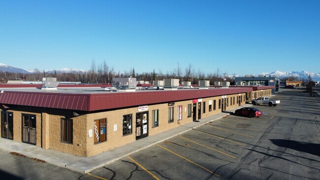

Property Detail
190 E Paulson Ave
Anchorage, AK
THOMAS ADD #2 BLOCK 1 LOT 10
1098B01L010
Matanuska Susitna
Commercialnec
Alaska
35
10
B and X Area of moderate flood hazard, usually the area between the limits of the 100-year and 500-year floods.
0.54 AC
2024
Mat-Su Business Region
2025
Anchorage
000800
NEARBY LISTINGS FOR SALE OR LEASE
DEMOGRAPHICS near 190 E Paulson Ave
1 mile
3 mile
5 mile
2025 Total Population
4,608
25,473
46,141
2030 Population
5,038
27,578
49,728
Pop Growth 2025-2030
+ 9.33%
+ 8.26%
+ 7.77%
Average Age
38
37
37
2025 Total Households
1,866
9,345
16,421
HH Growth 2025-2030
+ 9.43%
+ 8.41%
+ 7.90%
Median Household Inc
$60,833
$83,440
$93,369
Avg Household Size
2.40
2.70
2.70
2025 Avg HH Vehicles
2.00
2.00
2.00
Median Home Value
$325,773
$348,438
$356,355
Median Year Built
1999
1999
2000
Nearby Places
Map Layers
Map Styles
 Street
 Aerial
Layers
 Traffic
 Biking
Places
Listings with unknown addresses are not visible on the map
- Restaurants
- Banks
- Shops
- Fitness
- Groceries
PUBLIC TRANSPORTATION
AIRPORT
Merrill Field
Drive
Walk
Distance
Merrill Field
54 min
42.4 mi
Freight Ports
Port of Anchorage
Drive
Walk
Distance
Port of Anchorage
60 min
45.1 mi
SALE & LEASE HISTORY
LISTING DATE
SALE/LEASE

Jun 13, 2024
For Lease
Nearby Properties
Address
Land Use
TOTAL SIZE
Lot Size
Zoning
Address
Land Use
TOTAL SIZE
Lot Size
Zoning
17.15 AC
35
Address
Land Use
TOTAL SIZE
Lot Size
Zoning
68.83 AC
35
Address
Land Use
TOTAL SIZE
Lot Size
Zoning
18.74 AC
35
Address
Land Use
TOTAL SIZE
Lot Size
Zoning
1,831 SF
16.86 AC
35
Address
Land Use
TOTAL SIZE
Lot Size
Zoning
33.48 AC
35
Address
Land Use
TOTAL SIZE
Lot Size
Zoning
6.98 AC
7
Address
Land Use
TOTAL SIZE
Lot Size
Zoning
185,670 SF
18.57 AC
35
Address
Land Use
TOTAL SIZE
Lot Size
Zoning
162,711 SF
13.30 AC
35
Address
Land Use
TOTAL SIZE
Lot Size
Zoning
3.88 AC
35
Address
Land Use
TOTAL SIZE
Lot Size
Zoning
20.37 AC
35
Address
Land Use
TOTAL SIZE
Lot Size
Zoning
3.06 AC
7
Address
Land Use
TOTAL SIZE
Lot Size
Zoning
106,350 SF
59.96 AC
35
Address
Land Use
TOTAL SIZE
Lot Size
Zoning
2.63 AC
7
Address
Land Use
TOTAL SIZE
Lot Size
Zoning
4.03 AC
35
Address
Land Use
TOTAL SIZE
Lot Size
Zoning
137.13 AC
7
Address
Land Use
TOTAL SIZE
Lot Size
Zoning
Address
Land Use
TOTAL SIZE
Lot Size
Zoning
80 AC
41
Address
Land Use
TOTAL SIZE
Lot Size
Zoning
27,216 SF
12.07 AC
35
Address
Land Use
TOTAL SIZE
Lot Size
Zoning
153,815 SF
11.24 AC
35
Address
Land Use
TOTAL SIZE
Lot Size
Zoning
4.95 AC
7
Address
Land Use
TOTAL SIZE
Lot Size
Zoning
11.66 AC
35
Address
Land Use
TOTAL SIZE
Lot Size
Zoning
38,919 SF
7.67 AC
35
Address
Land Use
TOTAL SIZE
Lot Size
Zoning
5.61 AC
7
Address
Land Use
TOTAL SIZE
Lot Size
Zoning
83,012 SF
6.37 AC
35
Address
Land Use
TOTAL SIZE
Lot Size
Zoning
83.11 AC
8
Address
Land Use
TOTAL SIZE
Lot Size
Zoning
120,550 SF
11.67 AC
35
Address
Land Use
TOTAL SIZE
Lot Size
Zoning
7.06 AC
7
Address
Land Use
TOTAL SIZE
Lot Size
Zoning
30,349 SF
6.41 AC
35
Address
Land Use
TOTAL SIZE
Lot Size
Zoning
5.21 AC
35
Address
Land Use
TOTAL SIZE
Lot Size
Zoning
24,657 SF
3 AC
35
The World's #1 Commercial Real Estate Marketplace
Connect with us
© 2026 CoStar Group
The information above has been obtained from sources believed reliable. While we do not doubt its accuracy we have not verified it and make no guarantee, warranty or representation about it. It is your responsibility to independently confirm its accuracy and completeness. Any projections, opinions, assumptions, or estimates used are for example only and do not represent the current or future performance of the property. The value of this transaction to you depends on tax and other factors which should be evaluated by your tax, financial, and legal advisors. You and your advisors should conduct a careful, independent investigation of the property to determine to your satisfaction the suitability of the property for your needs.