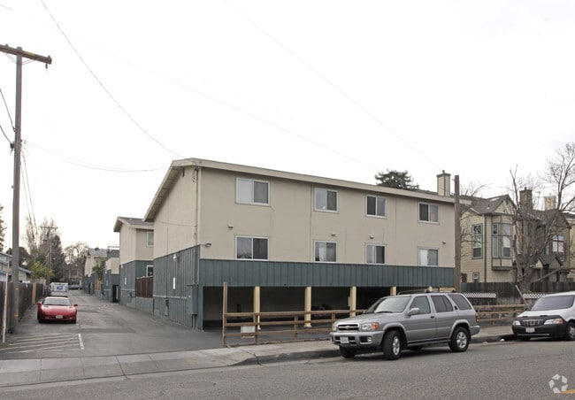
Property Record
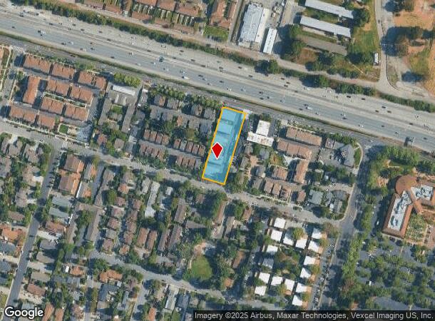
190 Evandale Ave, Mountain View, CA 94043
This Property Is For Sale
NEARBY LISTINGS FOR SALE OR LEASE
Property Detail
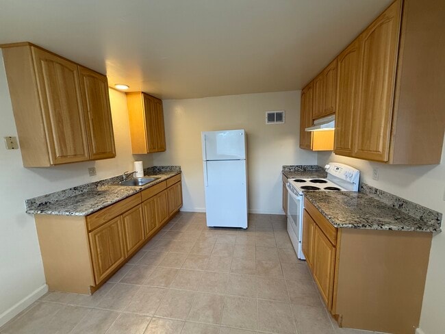
190 Evandale Ave
Multifamilydwelling
Santa Clara
X
California
06085C0045H
0.73 AC
2024
Wagon Wheel
2025
South Bay/San Jose
509108
San Jose-Sunnyvale-Santa Clara, CA
19,290 SF
160-07-008
DEMOGRAPHICS near 190 Evandale Ave
1 Mile
3 Mile
5 Mile
2024 Total Population
14,528
152,743
333,327
2029 Population
14,284
149,051
324,063
Pop Growth 2024-2029
(1.68%)
(2.42%)
(2.78%)
Average Age
36
38
39
2024 Total Households
6,088
61,860
127,349
HH Growth 2024-2029
(2.00%)
(2.58%)
(2.91%)
Median Household Inc
$169,404
$167,895
$181,405
Avg Household Size
2.30
2.40
2.50
2024 Avg HH Vehicles
2.00
2.00
2.00
Median Home Value
$1,105,218
$1,119,635
$1,127,206
Median Year Built
1977
1975
1973
Nearby Places
Map Layers
Map Styles
 Street
 Aerial
- Restaurants
- Banks
- Shops
- Fitness
- Groceries
PUBLIC TRANSPORTATION
TRANSIT/SUBWAY
Bayshore Nasa Station (Mountain View - Alum Rock - VTA, Mountain View - Alum Rock Modified-W - VTA)
DRIVE
WALK
Distance
Bayshore Nasa Station (Mountain View - Alum Rock - VTA, Mountain View - Alum Rock Modified-W - VTA)
2 min
14 min
0.7 mi
Bayshore/Nasa Station (Mountain View - Winchester Line - Santa Clara VTA Light Rail)
DRIVE
WALK
Distance
Bayshore/Nasa Station (Mountain View - Winchester Line - Santa Clara VTA Light Rail)
2 min
14 min
0.8 mi
Middlefield Station (Mountain View - Winchester Line - Santa Clara VTA Light Rail)
DRIVE
WALK
Distance
Middlefield Station (Mountain View - Winchester Line - Santa Clara VTA Light Rail)
3 min
20 min
1.0 mi
COMMUTER RAIL
Mountain View (Caltrain - Caltrain (Caltrain))
DRIVE
WALK
Distance
Mountain View (Caltrain - Caltrain (Caltrain))
6 min
2.4 mi
Mountain View Caltrain Station Southbound (Express - Caltrain (Caltrain), Limited - Caltrain (Caltrain), Local Weekday - Caltrain (Caltrain), Local Weekend - Caltrain (Caltrain))
DRIVE
WALK
Distance
Mountain View Caltrain Station Southbound (Express - Caltrain (Caltrain), Limited - Caltrain (Caltrain), Local Weekday - Caltrain (Caltrain), Local Weekend - Caltrain (Caltrain))
6 min
2.4 mi
AIRPORT
Norman Y Mineta San Jose International
DRIVE
WALK
Distance
Norman Y Mineta San Jose International
12 min
8.3 mi
San Francisco International
DRIVE
WALK
Distance
San Francisco International
33 min
25.6 mi
Metro Oakland International
DRIVE
WALK
Distance
Metro Oakland International
46 min
34.3 mi
Freight Ports
Port of Redwood City
DRIVE
WALK
Distance
Port of Redwood City
18 min
12.4 mi
Nearby Properties
Address
Land Use
TOTAL SIZE
Lot Size
Zoning
Address
Land Use
TOTAL SIZE
Lot Size
Zoning
42.28 AC
PF
Address
Land Use
TOTAL SIZE
Lot Size
Zoning
499,360 SF
31.95 AC
MM40
Address
Land Use
TOTAL SIZE
Lot Size
Zoning
0.33 AC
PF
Address
Land Use
TOTAL SIZE
Lot Size
Zoning
1,640,399 SF
101.23 AC
MP-I
Address
Land Use
TOTAL SIZE
Lot Size
Zoning
450,575 SF
3.73 AC
P(9)
Address
Land Use
TOTAL SIZE
Lot Size
Zoning
318,172 SF
60.47 AC
MP-TO
Address
Land Use
TOTAL SIZE
Lot Size
Zoning
355,490 SF
26.49 AC
P39
Address
Land Use
TOTAL SIZE
Lot Size
Zoning
440,173 SF
25.33 AC
P39
Address
Land Use
TOTAL SIZE
Lot Size
Zoning
73,425 SF
14.20 AC
MS
Address
Land Use
TOTAL SIZE
Lot Size
Zoning
4 AC
DSP/1
Address
Land Use
TOTAL SIZE
Lot Size
Zoning
181,709 SF
24.01 AC
MPI
Address
Land Use
TOTAL SIZE
Lot Size
Zoning
81,250 SF
14.73 AC
MPT
Address
Land Use
TOTAL SIZE
Lot Size
Zoning
584,389 SF
5.25 AC
P(40)
Address
Land Use
TOTAL SIZE
Lot Size
Zoning
431,256 SF
12.43 AC
PPSP
Address
Land Use
TOTAL SIZE
Lot Size
Zoning
595,000 SF
7.42 AC
P(34)
Address
Land Use
TOTAL SIZE
Lot Size
Zoning
350,633 SF
1.08 AC
MPTOD
Address
Land Use
TOTAL SIZE
Lot Size
Zoning
350,633 SF
1.27 AC
MPTOD
Address
Land Use
TOTAL SIZE
Lot Size
Zoning
23.19 AC
MP-I
Address
Land Use
TOTAL SIZE
Lot Size
Zoning
350,633 SF
1.08 AC
MPTOD
Address
Land Use
TOTAL SIZE
Lot Size
Zoning
587,826 SF
2.54 AC
DSP/1
Address
Land Use
TOTAL SIZE
Lot Size
Zoning
353,745 SF
14.82 AC
PPSP
Address
Land Use
TOTAL SIZE
Lot Size
Zoning
233,124 SF
9.18 AC
P(7)
Address
Land Use
TOTAL SIZE
Lot Size
Zoning
17.25 AC
MPI
Address
Land Use
TOTAL SIZE
Lot Size
Zoning
4.13 AC
P39
Address
Land Use
TOTAL SIZE
Lot Size
Zoning
23,709 SF
7.48 AC
PPSP
Address
Land Use
TOTAL SIZE
Lot Size
Zoning
22,400 SF
11.43 AC
MP-TO
Address
Land Use
TOTAL SIZE
Lot Size
Zoning
350,633 SF
1.27 AC
MPTOD
Address
Land Use
TOTAL SIZE
Lot Size
Zoning
350,633 SF
1.27 AC
MPTOD
Address
Land Use
TOTAL SIZE
Lot Size
Zoning
312,510 SF
23.46 AC
P41
Address
Land Use
TOTAL SIZE
Lot Size
Zoning
372,859 SF
4.71 AC
P
The World's #1 Commercial Real Estate Marketplace
Connect with us
© 2026 CoStar Group
The information above has been obtained from sources believed reliable. While we do not doubt its accuracy we have not verified it and make no guarantee, warranty or representation about it. It is your responsibility to independently confirm its accuracy and completeness. Any projections, opinions, assumptions, or estimates used are for example only and do not represent the current or future performance of the property. The value of this transaction to you depends on tax and other factors which should be evaluated by your tax, financial, and legal advisors. You and your advisors should conduct a careful, independent investigation of the property to determine to your satisfaction the suitability of the property for your needs.