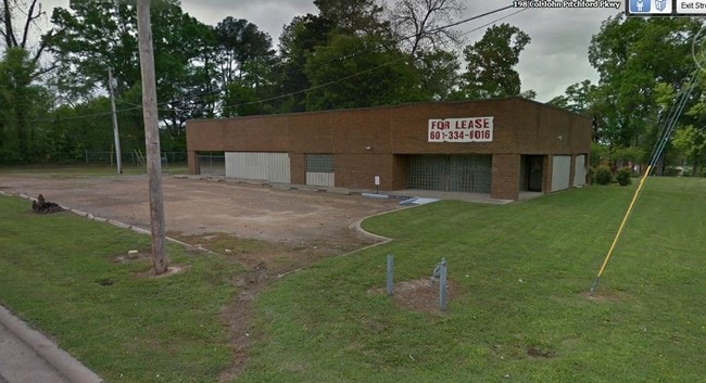
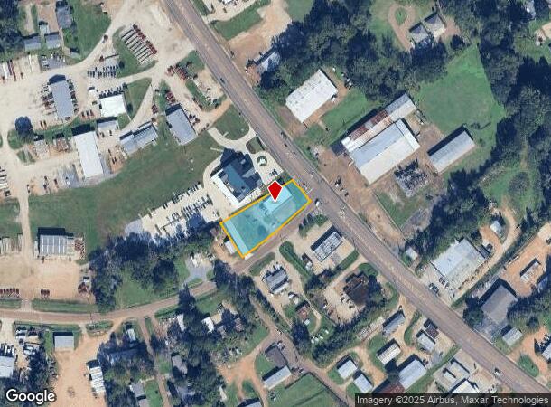
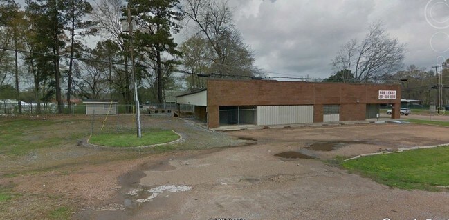
Property Record
190 Highway 61 S, Natchez, MS 39120
NEARBY LISTINGS FOR SALE OR LEASE
Property Detail
190 Highway 61 S
0080-0006-0038
Division Of Hunters' Hall Plantation
Officebuilding
B&PT L#2 HUNTERS HALL 58-101B-30
X
Adams
28001C0170D
Mississippi
2024
0.92 AC
2024
Hattiesburg/South Area
000900
Other Market Areas
4,171 SF
Natchez, MS-LA
DEMOGRAPHICS near 190 Highway 61 S
1 Mile
3 Mile
5 Mile
2024 Total Population
1,522
8,813
21,580
2029 Population
1,415
8,337
20,632
Pop Growth 2024-2029
(7.03%)
(5.40%)
(4.39%)
Average Age
47
43
42
2024 Total Households
674
3,944
9,533
HH Growth 2024-2029
(7.12%)
(5.25%)
(4.17%)
Median Household Inc
$65,150
$38,473
$34,545
Avg Household Size
2.10
2.10
2.20
2024 Avg HH Vehicles
2.00
2.00
2.00
Median Home Value
$202,193
$142,220
$112,665
Median Year Built
1971
1966
1965
Nearby Places
Map Layers
Map Styles
 Street
 Aerial
- Restaurants
- Banks
- Shops
- Fitness
- Groceries
SALE & LEASE HISTORY
LISTING DATE
SALE/LEASE

Apr 24, 2017
For Lease
Apr 17, 2017
For Sale
Apr 17, 2017
For Sale
Apr 17, 2017
For Sale
Nearby Properties
Address
Land Use
TOTAL SIZE
Lot Size
Zoning
Address
Land Use
TOTAL SIZE
Lot Size
Zoning
54,481 SF
90.99 AC
Address
Land Use
TOTAL SIZE
Lot Size
Zoning
25,489 SF
440 AC
Address
Land Use
TOTAL SIZE
Lot Size
Zoning
91.24 AC
RVR
Address
Land Use
TOTAL SIZE
Lot Size
Zoning
140,378 SF
24.10 AC
SUD
Address
Land Use
TOTAL SIZE
Lot Size
Zoning
178,600 SF
25 AC
B4
Address
Land Use
TOTAL SIZE
Lot Size
Zoning
13,431 SF
2.47 AC
B4
Address
Land Use
TOTAL SIZE
Lot Size
Zoning
1,080 SF
145 AC
SUD
Address
Land Use
TOTAL SIZE
Lot Size
Zoning
95,821 SF
9.81 AC
I1
Address
Land Use
TOTAL SIZE
Lot Size
Zoning
24,725 SF
1.10 AC
R4
Address
Land Use
TOTAL SIZE
Lot Size
Zoning
6,255 AC
Address
Land Use
TOTAL SIZE
Lot Size
Zoning
21 AC
R1
Address
Land Use
TOTAL SIZE
Lot Size
Zoning
44,504 SF
2.09 AC
B4
Address
Land Use
TOTAL SIZE
Lot Size
Zoning
25,000 SF
2.99 AC
B4
Address
Land Use
TOTAL SIZE
Lot Size
Zoning
2,748 SF
5.17 AC
R4
Address
Land Use
TOTAL SIZE
Lot Size
Zoning
246,514 SF
31.20 AC
B4
Address
Land Use
TOTAL SIZE
Lot Size
Zoning
576 SF
1.80 AC
B2
Address
Land Use
TOTAL SIZE
Lot Size
Zoning
11,684 SF
4.77 AC
B4
Address
Land Use
TOTAL SIZE
Lot Size
Zoning
7,070 SF
9.78 AC
Address
Land Use
TOTAL SIZE
Lot Size
Zoning
3,723 SF
6.51 AC
R4
Address
Land Use
TOTAL SIZE
Lot Size
Zoning
2,426 SF
10.49 AC
R4
Address
Land Use
TOTAL SIZE
Lot Size
Zoning
3,715 SF
5.60 AC
B4
Address
Land Use
TOTAL SIZE
Lot Size
Zoning
7,858 SF
3.39 AC
Address
Land Use
TOTAL SIZE
Lot Size
Zoning
27,570 SF
7.62 AC
B1
Address
Land Use
TOTAL SIZE
Lot Size
Zoning
11.33 AC
R4
Address
Land Use
TOTAL SIZE
Lot Size
Zoning
32,000 SF
4.92 AC
SUD
Address
Land Use
TOTAL SIZE
Lot Size
Zoning
15,027 SF
1.77 AC
B4
Address
Land Use
TOTAL SIZE
Lot Size
Zoning
21,242 SF
5.48 AC
SUD
Address
Land Use
TOTAL SIZE
Lot Size
Zoning
79,864 SF
7.14 AC
B4
Address
Land Use
TOTAL SIZE
Lot Size
Zoning
8,098 SF
3.56 AC
B4
Address
Land Use
TOTAL SIZE
Lot Size
Zoning
19,320 SF
9 AC
B4
The World's #1 Commercial Real Estate Marketplace
Connect with us
© 2025 CoStar Group
The information above has been obtained from sources believed reliable. While we do not doubt its accuracy we have not verified it and make no guarantee, warranty or representation about it. It is your responsibility to independently confirm its accuracy and completeness. Any projections, opinions, assumptions, or estimates used are for example only and do not represent the current or future performance of the property. The value of this transaction to you depends on tax and other factors which should be evaluated by your tax, financial, and legal advisors. You and your advisors should conduct a careful, independent investigation of the property to determine to your satisfaction the suitability of the property for your needs.